Oquaga Creek facts for kids
Quick facts for kids Oquaga Creek |
|
|---|---|

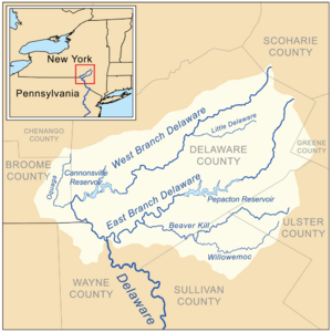
Delaware Headwaters map showing Oquaga Creek
|
|
| Country | United States |
| State | New York |
| Counties | Broome, Chenango |
| Physical characteristics | |
| Main source | Broome County, New York 42°12′17″N 75°25′19″W / 42.2048042°N 75.4218453°W |
| River mouth | West Branch Delaware River Deposit, New York, Broome County, New York, United States 971 ft (296 m) 42°03′28″N 75°25′22″W / 42.05778°N 75.42278°W |
| Basin features | |
| Basin size | 67.6 sq mi (175 km2) |
| Tributaries |
|
Oquaga Creek is a small but important river (or large creek) located in New York State. It flows through two different areas: Broome County and Chenango County. This creek eventually flows into a much larger river, the West Branch Delaware River, near the village of Deposit, New York.
Contents
About Oquaga Creek
Oquaga Creek is a natural waterway that plays a part in the larger Delaware River system. It helps carry water from the land into bigger rivers and eventually to the ocean. Creeks like Oquaga are important for the environment and for local communities.
Where Does Oquaga Creek Start?
The journey of Oquaga Creek begins in Broome County, New York. This is where the water first gathers to form the creek. The exact starting point is located at coordinates 42°12′17″N 75°25′19″W / 42.2048042°N 75.4218453°W. From there, it begins its flow, collecting more water as it travels.
Where Does Oquaga Creek End?
After flowing for some distance, Oquaga Creek reaches its end point. It joins the West Branch Delaware River. This meeting point is near the village of Deposit, which is also in Broome County, New York. The elevation at this spot is about 971 ft (296 m) above sea level. The coordinates for where it joins the bigger river are 42°03′28″N 75°25′22″W / 42.05778°N 75.42278°W.
What Streams Flow into Oquaga Creek?
Many smaller streams and brooks contribute their water to Oquaga Creek. These smaller waterways are called tributaries. They help make Oquaga Creek bigger and stronger as it flows.
On the left side of the creek (if you were looking downstream), these streams join:
On the right side, you would find these streams flowing in:
- Dry Brook
- Page Pond Brook
- Marsh Creek
- Fly Creek
All these smaller streams add to the total amount of water in Oquaga Creek.
The Oquaga Creek Watershed
The area of land that drains water into Oquaga Creek is called its watershed or drainage basin. For Oquaga Creek, this area covers about 67.6 sq mi (175 km2). This means that all the rain and snow that falls within this 67.6 square mile area will eventually flow into Oquaga Creek. Understanding a watershed helps us know how water moves across the land and how important it is to keep the land clean.
 | Lonnie Johnson |
 | Granville Woods |
 | Lewis Howard Latimer |
 | James West |

