Chenango County, New York facts for kids
Quick facts for kids
Chenango County
|
|||
|---|---|---|---|

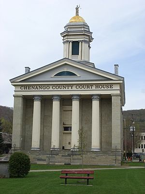
Chenango County Courthouse
|
|||
|
|||

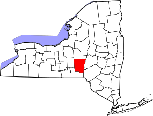
Location within the U.S. state of New York
|
|||
 New York's location within the U.S. |
|||
| Country | |||
| State | |||
| Founded | March 15, 1798 | ||
| Named for | Onondaga word for bull thistle | ||
| Seat | Norwich | ||
| Largest city | Norwich | ||
| Area | |||
| • Total | 899 sq mi (2,330 km2) | ||
| • Land | 894 sq mi (2,320 km2) | ||
| • Water | 5.1 sq mi (13 km2) 0.6% | ||
| Population
(2020)
|
|||
| • Total | 47,220 | ||
| • Density | 52.8/sq mi (20.4/km2) | ||
| Time zone | UTC−5 (Eastern) | ||
| • Summer (DST) | UTC−4 (EDT) | ||
| Congressional district | 19th | ||
Chenango County is a place in the middle-south part of New York. It is a type of local government area called a county. In 2020, about 47,220 people lived here. The main town, or county seat, is Norwich. The name "Chenango" comes from an Oneida word. It means 'large bull-thistle'. This county is part of the "Southern Tier" region of New York State.
Contents
History of Chenango County
Long ago, this area was the home of the Oneida people. They were one of the first five nations of the Iroquois Confederacy, also known as the Haudenosaunee. They lived here until after the American Revolutionary War. Even though they helped the American colonists, they were later forced to leave their land. They were given a small area, but settlers kept moving onto it.
When English colonists first set up counties in New York in 1683, Chenango County was part of a huge area called Albany County. This county was enormous! It covered much of northern New York, all of what is now Vermont, and was thought to stretch all the way to the Pacific Ocean. However, the French controlled areas west of Pennsylvania. Albany County became smaller over time as new counties were created.
In 1772, Albany County was divided again. A new part, Tryon County, was formed. It covered the western part of New York. This area was named after William Tryon, who was the British governor of New York.
Before the American Revolutionary War, many people in Tryon County who supported the British moved away. After the war ended in 1784, Americans changed the name of Tryon County. They renamed it Montgomery County. This was to honor General Richard Montgomery, an American hero. He had captured places in Canada and died trying to take the city of Quebec.
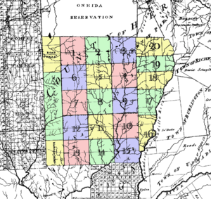
In 1788, the Oneida people sold a lot of their land. This land was west of the Unadilla River. It became known as "Clinton's Purchase" and formed 20 new towns. People from eastern New York and New England moved in and started farms.
Over the next few years, Montgomery County was also divided many times. This created many of the counties we know today. It was common to make a very large county first. Then, as more people moved in, they would split it into smaller ones.
Chenango County was officially formed on March 15, 1798. It was made from parts of Tioga and Herkimer counties. Its eastern edge is the Unadilla River. The land for Chenango County had been bought from the Oneida people the year before. They had to move to an even smaller area to the north.
Later, in 1804, a small part of Chenango County was given to Oneida County. Then, in 1806, a larger part of Chenango County was used to create Madison County. After these changes, Chenango County's borders have stayed the same. This area became a farming region in the 1800s and is still mostly rural today.
Geography of Chenango County
Chenango County covers about 899 square miles. Most of this (894 square miles) is land. Only a small part (about 5.1 square miles) is water.
The county is located in the middle of New York State. It is west of Albany, north of Binghamton, and southeast of Syracuse. It is part of the "Southern Tier" region of New York.
The Chenango River flows south through the county. This river is a branch of the Susquehanna River.
Neighboring Counties
Chenango County shares its borders with these other counties:
- Madison County - to the north
- Otsego County - to the northeast
- Delaware County - to the southeast
- Broome County - to the south
- Cortland County - to the west
Population Information
| Historical population | |||
|---|---|---|---|
| Census | Pop. | %± | |
| 1800 | 15,666 | — | |
| 1810 | 21,704 | 38.5% | |
| 1820 | 31,215 | 43.8% | |
| 1830 | 37,238 | 19.3% | |
| 1840 | 40,785 | 9.5% | |
| 1850 | 40,311 | −1.2% | |
| 1860 | 40,934 | 1.5% | |
| 1870 | 40,564 | −0.9% | |
| 1880 | 39,891 | −1.7% | |
| 1890 | 37,776 | −5.3% | |
| 1900 | 36,568 | −3.2% | |
| 1910 | 35,575 | −2.7% | |
| 1920 | 34,969 | −1.7% | |
| 1930 | 34,665 | −0.9% | |
| 1940 | 36,454 | 5.2% | |
| 1950 | 39,138 | 7.4% | |
| 1960 | 43,243 | 10.5% | |
| 1970 | 46,368 | 7.2% | |
| 1980 | 49,344 | 6.4% | |
| 1990 | 51,768 | 4.9% | |
| 2000 | 51,401 | −0.7% | |
| 2010 | 50,477 | −1.8% | |
| 2020 | 47,220 | −6.5% | |
| 2022 (est.) | 46,458 | −8.0% | |
| U.S. Decennial Census 1790-1960 1900-1990 1990-2000 2010-2020 |
|||
In 2020, the population of Chenango County was 47,220 people. Most people living here are White. There are also smaller groups of Black or African American, Native American, Asian, and Pacific Islander people. About 2.37% of the population is Hispanic or Latino.
Education in Chenango County
Morrisville State College has a campus located in Norwich.
Communities in Chenango County
The only city in Chenango County is Norwich. This is also the county seat.
Besides Norwich, there are many other towns and villages.
Towns
In New York, a "town" is a local government area. The towns in northern Chenango County were part of the "Twenty Townships" bought from the Oneida tribe.
Villages
Census-Designated Places
These are areas that are like villages but are not officially incorporated:
Hamlets
These are smaller communities within towns:
- Holmesville
- Mount Upton
- Rockdale
- South Plymouth
Famous People From Chenango County
Some notable people were born or lived in Chenango County:
- Allen Aaron Cook, an architect, was born here in 1832.
- Nancy Matthews Elliott was born here in 1810. She later became the mother of the famous inventor Thomas Edison.
- Serranus Clinton Hastings, a U.S. Congressman, founded the Hastings College of the Law at the University of California.
See also
 In Spanish: Condado de Chenango para niños
 | Aurelia Browder |
 | Nannie Helen Burroughs |
 | Michelle Alexander |


