Pharsalia, New York facts for kids
Quick facts for kids
Pharsalia, New York
|
|
|---|---|
 |
|
| Country | United States |
| State | New York |
| County | Chenango |
| Government | |
| • Type | Town Council |
| Area | |
| • Total | 39.12 sq mi (101.31 km2) |
| • Land | 38.82 sq mi (100.53 km2) |
| • Water | 0.30 sq mi (0.77 km2) |
| Elevation | 1,883 ft (574 m) |
| Population
(2010)
|
|
| • Total | 593 |
| • Estimate
(2019)
|
569 |
| • Density | 14.89/sq mi (5.75/km2) |
| Time zone | UTC-5 (Eastern (EST)) |
| • Summer (DST) | UTC-4 (EDT) |
| FIPS code | 36-017-57507 |
| GNIS feature ID | 0979360 |
Pharsalia is a small town located in Chenango County, New York, United States. In 2010, about 593 people lived there. The town got its name from a famous battle called the Battle of Pharsalia. This battle was a big part of the Great Roman Civil War. It's where the Roman leader Julius Caesar defeated Pompey way back in 48 BCE.
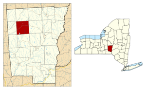
Pharsalia is in the western part of Chenango County. It's located northwest of the city of Norwich. As of 2017, the town has a population of around 570 people.
Contents
History of Pharsalia
The first person to settle in the area that is now Pharsalia arrived in 1797. The town was officially created in 1806. It was formed from a part of the town of Norwich.
When it was first founded, it was called "Stonington." However, just two years later, in 1808, the town's name was changed to "Pharsalia."
Geography and Landscape
Pharsalia covers a total area of about 39.12 square miles (101.3 square kilometers). Most of this area, about 38.82 square miles (100.5 square kilometers), is land. The rest, about 0.30 square miles (0.8 square kilometers), is water. This means only a small part of the town is covered by water.
New York State Route 23 is a main road that goes through the town. It runs from east to west, helping people travel across Pharsalia.
Population Changes Over Time
| Historical population | |||
|---|---|---|---|
| Census | Pop. | %± | |
| 1820 | 873 | — | |
| 1830 | 987 | 13.1% | |
| 1840 | 1,213 | 22.9% | |
| 1850 | 1,185 | −2.3% | |
| 1860 | 1,261 | 6.4% | |
| 1870 | 1,141 | −9.5% | |
| 1880 | 1,147 | 0.5% | |
| 1890 | 915 | −20.2% | |
| 1900 | 780 | −14.8% | |
| 1910 | 657 | −15.8% | |
| 1920 | 553 | −15.8% | |
| 1930 | 464 | −16.1% | |
| 1940 | 676 | 45.7% | |
| 1950 | 480 | −29.0% | |
| 1960 | 515 | 7.3% | |
| 1970 | 520 | 1.0% | |
| 1980 | 606 | 16.5% | |
| 1990 | 735 | 21.3% | |
| 2000 | 542 | −26.3% | |
| 2010 | 593 | 9.4% | |
| 2019 (est.) | 569 | −4.0% | |
| U.S. Decennial Census | |||
According to the census from 2000, there were 542 people living in Pharsalia. These people lived in 200 households, and 154 of those were families. The population density was about 14 people per square mile.
Most of the people in Pharsalia were White (98.71%). A small number were African American (0.55%) or Native American (0.18%). About 0.55% of the population identified as two or more races. Also, 0.74% of the population was Hispanic or Latino.
The average household in Pharsalia had 2.71 people. For families, the average size was 3.05 people. About 40% of households had children under 18 living with them. Many households (59.5%) were married couples living together.
The median age in Pharsalia was 36 years old. About 29.9% of the population was under 18 years old. Another 11.1% were 65 years or older.
Communities and Places in Pharsalia
Pharsalia is home to several smaller communities and interesting spots:
- Balsam Lake – This is a lake located southeast of the main Pharsalia village.
- East Pharsalia – A small hamlet found southeast of Pharsalia village. It's near the southern border of the town.
- North Pharsalia – Another hamlet located northeast of Pharsalia village, right on NY-23.
- Northwest Corners – This hamlet is in the northwestern part of the town.
- Pharsalia – This is the main hamlet of Pharsalia. It's located on NY-23, close to the western edge of the town.
- Pharsalia Wildlife Management Area – This is a special area in the northern part of the town. It's set aside to protect wildlife and their habitats.
- Waldron Corners – You can find this spot near the western town line, along County Road 42.
Neighboring Towns
Pharsalia shares its borders with several other towns:
- Otselic – To the north
- Smyrna – To the northeast
- Plymouth – To the east
- Preston – To the southeast
- McDonough – To the south
- German – To the southwest
- Pitcher – To the west
See also
 In Spanish: Pharsalia (Nueva York) para niños
 | Jewel Prestage |
 | Ella Baker |
 | Fannie Lou Hamer |


