Otselic, New York facts for kids
Quick facts for kids
Otselic, New York
|
|
|---|---|

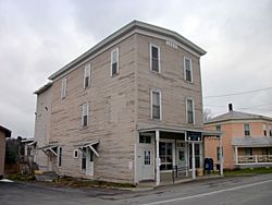
U.S. Post Office (Dew Drop Building), South Otselic, November 2010
|
|
 |
|
| Country | United States |
| State | New York |
| County | Chenango |
| Government | |
| • Type | Town Council |
| Area | |
| • Total | 38.04 sq mi (98.52 km2) |
| • Land | 37.98 sq mi (98.36 km2) |
| • Water | 0.06 sq mi (0.16 km2) |
| Elevation | 1,650 ft (503 m) |
| Population
(2010)
|
|
| • Total | 1,054 |
| • Estimate
(2016)
|
1,023 |
| • Density | 26.94/sq mi (10.40/km2) |
| Time zone | UTC-5 (Eastern (EST)) |
| • Summer (DST) | UTC-4 (EDT) |
| FIPS code | 36-017-55717 |
| GNIS feature ID | 0979330 |
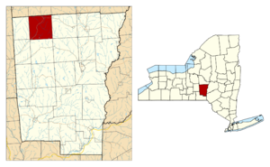
Otselic is a small town in Chenango County, New York. It's located in the central part of New York State. In 2010, about 1,054 people lived here.
The town gets its name from the Otselic River that flows through it. The word "Otselic" comes from the Oneida language and means "place of wild plums." The Otselic Valley is a major natural feature in the town. It connects Otselic to other areas both north and south.
Contents
A Look at Otselic's Past
The first settlers arrived in the Otselic area around the year 1800. Many of these early families came from states like Connecticut and Massachusetts.
The town of Otselic was officially created in 1817. It was formed from a part of the nearby town of German. A big event in Otselic's history happened in 1833. A very wide tornado, measuring over a mile across, passed over the town that year.
Where is Otselic?
Otselic covers an area of about 98.5 square kilometers (about 38 square miles). Most of this area is land, with only a small part being water.
A large portion of the town, over 10 square miles (about 7,000 acres), is state-owned forest land. These forests are used to grow trees for wood products. They are also open to the public for fun outdoor activities. You can go hunting, camping, fishing, hiking, and cross-country skiing there.
The highest point in Otselic is over 2,000 feet above sea level. This is along the southern border of the town. The lowest point is about 1,200 feet, found at the bottom of the Otselic Valley. The northern border of Otselic touches Madison County.
The Otselic River flows through the town. This river eventually joins the Tioughnioga River. Both are part of the Susquehanna River watershed, which flows into Chesapeake Bay. Major roads like New York State Route 26 and New York State Route 80 meet in the Otselic hamlet.
Amazing Wildlife
Years ago, most of the land in Otselic was used for farming, especially dairy farms. Over time, many farms were left empty. Now, forests and new forest growth cover most of the land. You can still see some dairy farms, though.
The forests are a mix of different trees. These include maple, cherry, ash, beech, basswood, birch, and hemlock. There are also large areas of spruce and pine trees planted by the state. Many white pine trees used to grow here. But they were cut down in the 1800s for their valuable wood.
Hunting, trapping, and watching wildlife are popular activities. Many animals live in Otselic. You might see white-tailed deer, beavers, mink, muskrats, and different kinds of squirrels. Other animals include coyotes, foxes, skunks, raccoons, porcupines, and bears.
Otselic is also a great place for birds. Turkeys and grouse are common game birds. During summer, over 100 different types of birds breed in the area. This is one of the highest numbers in New York State! You can spot Bald eagles and osprey along the Otselic River. Ravens are also returning to the hills. Sometimes, rare red and white-winged crossbills from Canada breed in the large pine forests.
People of Otselic
| Historical population | |||
|---|---|---|---|
| Census | Pop. | %± | |
| 1820 | 526 | — | |
| 1830 | 1,238 | 135.4% | |
| 1840 | 1,621 | 30.9% | |
| 1850 | 1,800 | 11.0% | |
| 1860 | 1,752 | −2.7% | |
| 1870 | 1,733 | −1.1% | |
| 1880 | 1,512 | −12.8% | |
| 1890 | 1,284 | −15.1% | |
| 1900 | 1,234 | −3.9% | |
| 1910 | 1,104 | −10.5% | |
| 1920 | 996 | −9.8% | |
| 1930 | 880 | −11.6% | |
| 1940 | 905 | 2.8% | |
| 1950 | 896 | −1.0% | |
| 1960 | 854 | −4.7% | |
| 1970 | 925 | 8.3% | |
| 1980 | 955 | 3.2% | |
| 1990 | 990 | 3.7% | |
| 2000 | 1,001 | 1.1% | |
| 2010 | 1,054 | 5.3% | |
| 2016 (est.) | 1,023 | −2.9% | |
| U.S. Decennial Census | |||
In 2010, the town of Otselic had 1,054 people living there. This number is about half of what it was in 1875. The population density was about 26 people per square mile.
There were 356 households in Otselic. About 36% of these households had children under 18 living with them. Most people in Otselic are White (98.7%). A small number are Native American, Asian, or from other backgrounds. About 1.4% of the population was Hispanic or Latino.
The average household had about 2.81 people. The average family had about 3.15 people. The median age in Otselic was 34 years old. This means half the people were younger than 34, and half were older.
Exploring Otselic's Areas
Otselic has several small communities and interesting spots:
- Beaver Meadow – A small community in the southeastern part of town. Its name comes from low areas that were often flooded by beaver dams.
- The Gorge – A deep valley with a brook that flows into South Otselic. In 1850, a special road called The Plank Road was built here. It was made of hemlock planks and connected South Otselic to Norwich.
- Mariposa – An area west of South Otselic along County Road 13.
- Otselic – This is the main hamlet of the town. It's near the northern town line where NY Route 26 and NY Route 80 meet. The Otselic River flows nearby.
- Otselic Center – A hamlet located between Otselic village and Seventh Day Hollow on NY-26.
- Ratville – An area on Ratville Road. It might have been named for many rats at a grain mill or many muskrats in a swamp nearby.
- Rhode Island – A location near the western town line.
- The Ridge – A mountain that runs north from South Otselic. It's crossed by Ridge Road and was once called Pleasant Ridge.
- Sandersonville – A group of homes along NY State Highway 26, south of the South Otselic Fish Hatchery. It's named after the original Sanderson Farm.
- Seventh Day Hollow – A hamlet northeast of South Otselic. It was named for the Seventh Day Baptists who settled and built a church there. In the 1800s, a mill was built on the Otselic River here.
- South Otselic – A hamlet in the southwest part of town. It's on NY-26 and the Otselic River. This hamlet was once home to Gladding Fishing Line, a famous company. Many historic buildings here are listed on the National Register of Historic Places. In the 1800s, South Otselic had a dam, sawmills, a grain mill, hotels, stores, and a rope factory. It is also the resting place of Grace Brown.
- South Otselic State Fish Hatchery – A place where fish are raised, located south of South Otselic.
- Stanbro – A former hamlet northwest of Beaver Meadow, named after the Stanbro family.
- Tallet Hill – A hilltop north and west of South Otselic. It was settled by the Tallet family.
- Truman Hill – A hilltop next to Tallet Hill, named after the Truman family who settled there.
- Upper Beaver Meadow – This area was also called Beaver Meadow. It was at the upstream end of the beaver dammed area.
Notable People
- George W. Ray – A former member of the U.S. Congress.
See also
 In Spanish: Otselic (Nueva York) para niños
 | William L. Dawson |
 | W. E. B. Du Bois |
 | Harry Belafonte |


