Preston, New York facts for kids
Quick facts for kids
Preston, New York
|
|
|---|---|

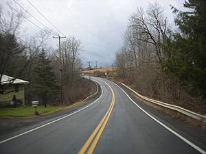
Chenango CR 10A, former NYS Route 319 in Preston
|
|
 |
|
| Country | United States |
| State | New York |
| County | Chenango |
| Government | |
| • Type | Town Council |
| Area | |
| • Total | 35.05 sq mi (90.77 km2) |
| • Land | 34.88 sq mi (90.33 km2) |
| • Water | 0.17 sq mi (0.44 km2) |
| Elevation | 1,358 ft (414 m) |
| Population
(2010)
|
|
| • Total | 1,044 |
| • Estimate
(2019)
|
984 |
| • Density | 28.87/sq mi (11.15/km2) |
| Time zone | UTC-5 (Eastern (EST)) |
| • Summer (DST) | UTC-4 (EDT) |
| ZIP code |
13830
|
| Area code(s) | 607 |
| FIPS code | 36-017-59817 |
| GNIS feature ID | 0979398 |
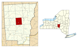
Preston is a small town located in Chenango County, New York. In 2010, about 1,044 people lived there. It is in the middle of Chenango County, just west of the city of Norwich.
Contents
Discovering Preston's Past
The first people settled in Preston around 1787. The town was officially formed from the town of Norwich in 1806. A small part of Preston was given back to Norwich in 1808.
Later, in 1816, a section of Preston was used to create a new town called McDonough. In 1820, another part of Norwich was added to Preston. By 1865, the town's population was 982 people.
A famous botanist, Frederick Vernon Coville (1867–1937), was born in Preston. He wrote an important book called Botany of the Death Valley Expedition.
Exploring Preston's Geography
Preston covers a total area of about 90.8 square kilometers (or 35.05 square miles). Most of this area, about 90.3 square kilometers (34.88 square miles), is land. The rest, about 0.4 square kilometers (0.17 square miles), is water.
Preston's Population Story
| Historical population | |||
|---|---|---|---|
| Census | Pop. | %± | |
| 1820 | 1,092 | — | |
| 1830 | 1,213 | 11.1% | |
| 1840 | 1,117 | −7.9% | |
| 1850 | 1,082 | −3.1% | |
| 1860 | 1,013 | −6.4% | |
| 1870 | 957 | −5.5% | |
| 1880 | 909 | −5.0% | |
| 1890 | 762 | −16.2% | |
| 1900 | 602 | −21.0% | |
| 1910 | 649 | 7.8% | |
| 1920 | 618 | −4.8% | |
| 1930 | 579 | −6.3% | |
| 1940 | 672 | 16.1% | |
| 1950 | 676 | 0.6% | |
| 1960 | 753 | 11.4% | |
| 1970 | 714 | −5.2% | |
| 1980 | 941 | 31.8% | |
| 1990 | 1,100 | 16.9% | |
| 2000 | 928 | −15.6% | |
| 2010 | 1,044 | 12.5% | |
| 2019 (est.) | 984 | −5.7% | |
| U.S. Decennial Census | |||
In 2000, a census showed that 928 people lived in Preston. There were 344 households, with 243 of them being families. On average, there were about 2.59 people in each household.
Most people in Preston were White (97.74%). A small number were African American (0.86%), Native American (0.22%), or Asian (0.32%). Some people were from other backgrounds (0.32%) or mixed races (0.54%). About 0.54% of the population was Hispanic or Latino.
About 34% of households had children under 18 living with them. Most households (57.3%) were married couples. About 29.1% of households were not families.
The population's age was spread out. About 25.3% were under 18 years old. The median age was 39 years. This means half the people were younger than 39, and half were older.
The average income for a household in Preston was $32,431. For families, it was $37,917. About 11.5% of the population lived below the poverty line. This included 9.1% of those under 18 and 9.6% of those 65 or older.
Communities and Places in Preston
- Fly Meadow Creek – This is a stream that flows southeast through the town. It eventually reaches the Chenango River.
- Nortons Corners – You can find this spot in the southwestern part of the town.
- Preston – This is the main hamlet (a small village) of Preston. It is where County Roads 4, 10, 10A, and 19 meet, right by Fly Meadow Creek.
- Preston Center – This is another hamlet located southeast of the main Preston village. It is found on County Road 4.
- Steer Pond – This is a small lake located near the western border of the town.
See also
 In Spanish: Preston (Nueva York) para niños
 | Selma Burke |
 | Pauline Powell Burns |
 | Frederick J. Brown |
 | Robert Blackburn |


