Chenango River facts for kids
Quick facts for kids Chenango River |
|
|---|---|

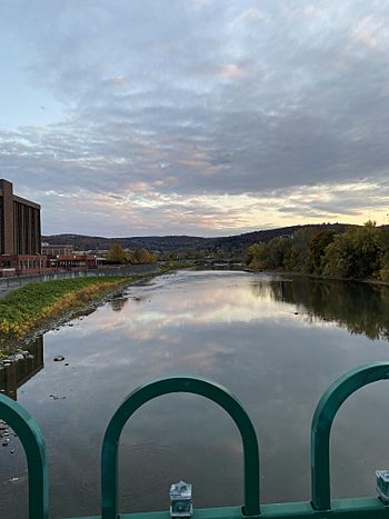
Chenango River from Court Street Bridge in Binghamton, New York, near its confluence with the Susquehanna River
|
|
| Country | United States |
| State | New York |
| Physical characteristics | |
| Main source | Campbell Lakes, Morrisville Swamp Morrisville, Madison County, New York, United States 1,290 ft (390 m) 42°56′23″N 75°40′06″W / 42.93972°N 75.66833°W |
| River mouth | Susquehanna River Binghamton, Broome County, New York, New York, United States 820 ft (250 m) 42°05′32″N 75°55′02″W / 42.09222°N 75.91722°W |
| Length | 90 mi (140 km) |
| Basin features | |
| Basin size | 1,582 sq mi (4,100 km2) |
| Tributaries |
|
The Chenango River is a 90-mile long river in central New York. It's like a smaller stream that flows into a bigger river, the Susquehanna River. The Chenango River helps drain a large area of land in upstate New York.
Its name comes from an Oneida word that means "bull thistle." Long ago, in the 1800s, the Chenango River was an important part of a canal system. The Chenango Canal was built to connect the Erie Canal in the north to the Susquehanna River. This canal helped transport goods. But later, railroads became more popular, so the canal was no longer used after 1878.
Sometimes, especially in spring and fall, the river can flood.
Contents
Where Does the Chenango River Flow?

The Chenango River starts near Morrisville in Madison County, central New York. It begins in the Morrisville Swamp, about 25 miles southwest of Utica. The river gets its water from the Campbell Lakes within the swamp. Water also flows in from the Smithfield Hills and a series of cliffs called "The Ledges."
From Morrisville, the river flows south. It passes towns like Eaton and Hamilton. You can still see parts of the old Chenango Canal alongside the river in some areas. South of Earlville, another river called the Sangerfield River joins the Chenango.
The Chenango River continues south past Sherburne to Norwich. Here, it turns southwest. It then flows past Oxford, Brisben, and Greene. Near Chenango Forks, about nine miles north of Binghamton, its biggest branch, the Tioughnioga River, flows into it. Finally, the Chenango River ends in downtown Binghamton, Broome County. Here, it joins the larger Susquehanna. The Chenango River is about 90 miles long in total.
Rivers and Streams That Join the Chenango
Many smaller rivers and streams flow into the Chenango River. These are called tributaries. They add water to the main river as it flows along.
Tributaries from the Right
- Callahan Brook
- Electric Light Stream
- Eaton Brook
- Bradley Brook
- Kingsley Brook
- Stone Mill Brook
- Cold Spring Brook
- Fly Creek
- Cold Brook
- Canasawacta Creek
- Gilmore Brook
- Fly Meadow Creek
- Mill Brook
- Bowman Creek
- Tillotson Creek
- Spring Brook
- Genegantslet Creek
- Ockerman Brook
- Tioughnioga River
- Thomas Creek
- Castle Creek
- Cutler Creek
Tributaries from the Left
- Payne Brook
- Sangerfield River
- Mad Brook
- West Brook
- Whapanaka Brook
- Thompson Creek
- Ransford Creek
- Glen Road Brook
- Wheeler Brook
- Page Brook Creek
- Osborne Creek
- Phelps Creek
 | Anna J. Cooper |
 | Mary McLeod Bethune |
 | Lillie Mae Bradford |

