
Greene (village), New York facts for kids
Quick facts for kids
Greene, New York
|
|
|---|---|

Looking down Genesee Street
|
|

Greene (village), New York
Location in New York
|
|
| Country | United States |
| State | New York |
| County | Chenango |
| Town | Greene |
| Area | |
| • Total | 1.11 sq mi (2.86 km2) |
| • Land | 1.07 sq mi (2.77 km2) |
| • Water | 0.04 sq mi (0.10 km2) |
| Elevation | 919 ft (280 m) |
| Population
(2020)
|
|
| • Total | 1,463 |
| • Density | 1,369.85/sq mi (529.05/km2) |
| Time zone | UTC-5 (Eastern (EST)) |
| • Summer (DST) | UTC-4 (EDT) |
| ZIP code |
13778
|
| Area code(s) | 607 |
| FIPS code | 36-30411 |
| GNIS feature ID | 0951739 |
Greene is a small village located in Chenango County, New York, United States. It is named after General Nathanael Greene, a hero from the American Revolutionary War. The village is found within the larger town of Greene and sits northeast of the city of Binghamton. In 2020, about 1,463 people called Greene home.
Contents
History of Greene Village
The area where Greene village now stands was first settled around 1792. Stephen Ketchum was one of the very first people to live here. The settlement was originally called "Hornby."
In 1806, the town decided to change its name to honor General Nathanael Greene, a key leader during the Revolutionary War. The village of Greene was officially planned out in 1806 and became an incorporated village in 1842. This means it gained its own local government.
Many of Greene's old and important buildings were added to the National Register of Historic Places in 1982. This list helps protect places that are important to history. The Chenango River, which flows through the village, is home to various wildlife. You might spot animals like the great horned owl or the Virginia opossum there.
Geography and Location
Greene village is located in the southwestern part of Chenango County, New York. It sits just north of the center of the town of Greene. Its exact location is 42°19′48″N 75°46′12″W / 42.33000°N 75.77000°W.
The United States Census Bureau reports that the village covers a total area of about 1.11 square miles (2.9 square kilometers). Most of this area, about 1.07 square miles (2.8 square kilometers), is land. The rest, about 0.04 square miles (0.1 square kilometers), is water.
The village is built along the banks of the Chenango River. It was also once located near the old Chenango Canal, which was used for transportation. A railway line, once part of the Lackawanna Railroad, also follows the river through the area. However, this railway has not been active since severe floods in 2006.
Two important roads, New York State Route 12 and New York State Route 206, meet right in the village of Greene.
Population Changes Over Time
| Historical population | |||
|---|---|---|---|
| Census | Pop. | %± | |
| 1860 | 846 | — | |
| 1870 | 1,025 | 21.2% | |
| 1880 | 935 | −8.8% | |
| 1890 | 1,067 | 14.1% | |
| 1900 | 1,236 | 15.8% | |
| 1910 | 1,275 | 3.2% | |
| 1920 | 1,297 | 1.7% | |
| 1930 | 1,379 | 6.3% | |
| 1940 | 1,431 | 3.8% | |
| 1950 | 1,628 | 13.8% | |
| 1960 | 2,051 | 26.0% | |
| 1970 | 1,874 | −8.6% | |
| 1980 | 1,747 | −6.8% | |
| 1990 | 1,812 | 3.7% | |
| 2000 | 1,701 | −6.1% | |
| 2010 | 1,580 | −7.1% | |
| 2020 | 1,463 | −7.4% | |
| U.S. Decennial Census | |||
The population of Greene village has changed quite a bit over the years. In 1860, about 846 people lived there. The population grew steadily for many decades, reaching its highest point in 1960 with 2,051 residents.
Since then, the population has slowly decreased. In 2010, there were 1,580 people, and by the 2020 census, the population was 1,463.
Images for kids
-
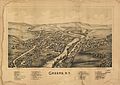
A lithograph of Greene published in 1890, showing various landmarks.

See also
 In Spanish: Greene (villa) para niños
