
Earlville, New York facts for kids
Quick facts for kids
Earlville, New York
|
|
|---|---|

Earlville Opera House
|
|
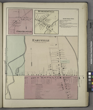
Earlville in 1875
|
|

Earlville, New York
Location in New York
|
|
| Country | United States |
| State | New York |
| Counties | Madison, Chenango |
| Towns | Hamilton, Sherburne |
| Area | |
| • Total | 1.08 sq mi (2.80 km2) |
| • Land | 1.08 sq mi (2.80 km2) |
| • Water | 0.00 sq mi (0.00 km2) |
| Elevation | 1,099 ft (335 m) |
| Population
(2020)
|
|
| • Total | 774 |
| • Density | 716.00/sq mi (276.49/km2) |
| Time zone | UTC-5 (Eastern (EST)) |
| • Summer (DST) | UTC-4 (EDT) |
| ZIP code |
13332
|
| Area code(s) | 315 |
| FIPS code | 36-21523 |
| GNIS feature ID | 0948958 |
Earlville is a small village in New York state, United States. It's unique because it sits across two different counties: Madison County and Chenango County.
In 2020, about 774 people lived in Earlville. This was a small drop from the 872 people who lived there in 2010. The village got its name from Jonas Earl, who was important in building canals.
Earlville is located where four different towns meet. These towns are Sherburne, Hamilton, Lebanon, and Smyrna. The main road, East and West Main streets, actually runs right along the county line. The part of Earlville in Madison County is also part of the larger Syracuse area.
The current Mayor of Earlville is Thomas Taylor.
Contents
Exploring Earlville's Past
How Earlville Began
People first started settling in this area around 1792. It was first known as "Forks" or "Madison Forks." The name changed to Earlville around 1835. This happened after the Chenango Canal was built. The village was named after the person who built this important canal.
After canals became less popular for transportation, trains helped the community. Railroad services kept businesses strong in Earlville.
Becoming a Village
Earlville officially became an incorporated village in 1887. This means it got its own local government. Many of the old buildings in Earlville are very special. The Earlville Historic District was added to a list of important places in 1982. This helps protect its history.
The Earlville Opera House
A famous building in the village is the Earlville Opera House. It was added to the historic places list in 1973. Today, it's a busy place! It has a theater for shows, two art galleries, a cozy arts cafe, and a gift shop where you can buy unique handmade items.
Where is Earlville?
Village Location and Rivers
Earlville is located at 42°44′28″N 75°32′38″W / 42.74111°N 75.54389°W. It sits between two rivers. The Chenango River is to the west. The Sangerfield River is to the east. The Sangerfield River flows into the Chenango River. The Chenango River then flows south into the larger Susquehanna River.
Village Size
The United States Census Bureau says that Earlville covers about 2.8 square kilometers (1.08 square miles). All of this area is land, with no large bodies of water.
Main Roads in Earlville
New York State Route 12B is a major road that runs through the middle of Earlville. It is known as North and South Main streets. East and West Main streets cross this highway. This crossing point is where the village is divided between Madison and Chenango counties.
Who Lives in Earlville?
Population Changes Over Time
| Historical population | |||
|---|---|---|---|
| Census | Pop. | %± | |
| 1870 | 399 | — | |
| 1880 | 293 | −26.6% | |
| 1890 | 536 | 82.9% | |
| 1900 | 711 | 32.6% | |
| 1910 | 874 | 22.9% | |
| 1920 | 792 | −9.4% | |
| 1930 | 868 | 9.6% | |
| 1940 | 864 | −0.5% | |
| 1950 | 945 | 9.4% | |
| 1960 | 1,004 | 6.2% | |
| 1970 | 1,050 | 4.6% | |
| 1980 | 985 | −6.2% | |
| 1990 | 883 | −10.4% | |
| 2000 | 791 | −10.4% | |
| 2010 | 872 | 10.2% | |
| 2020 | 774 | −11.2% | |
| U.S. Decennial Census | |||
In 2000, there were 791 people living in Earlville. There were 298 households, which are groups of people living together. About 219 of these were families. The population density was about 729 people per square mile.
Families and Age Groups
Many households in Earlville have children. In 2000, about 36% of households had kids under 18. Over half of the households were married couples living together.
The people in Earlville are of different ages. About 27% of the population was under 18 years old. About 13% were 65 years or older. The average age in the village was 38 years old.
Income Information
In 2000, the average income for a household in Earlville was $32,500. For families, the average income was $33,654. About 11.8% of all people in the village lived below the poverty line. This included about 15.6% of children under 18.
Earlville's Unique Homes
Earlville is famous for its beautiful old homes. Many of them are Victorian style. Some even have special "Second Empire mansard roofs." These homes often have bright, lively colors. They are like the "painted ladies" houses from that time period.
See also
 In Spanish: Earlville (Nueva York) para niños
