Columbus, New York facts for kids
Quick facts for kids
Columbus, New York
|
|
|---|---|
 |
|
| Country | United States |
| State | New York |
| County | Chenango |
| Government | |
| • Type | Town Council |
| Area | |
| • Total | 37.49 sq mi (97.10 km2) |
| • Land | 37.37 sq mi (96.78 km2) |
| • Water | 0.12 sq mi (0.32 km2) |
| Elevation | 1,427 ft (435 m) |
| Population
(2010)
|
|
| • Total | 975 |
| • Estimate
(2016)
|
946 |
| • Density | 25.32/sq mi (9.77/km2) |
| Time zone | UTC-5 (Eastern (EST)) |
| • Summer (DST) | UTC-4 (EDT) |
| ZIP code |
13411, 13485, 13460
|
| Area code(s) | 607 |
| FIPS code | 36-017-17486 |
| GNIS feature ID | 0978856 |
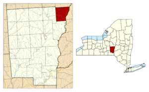
Columbus is a small town located in Chenango County, New York, in the United States. In 2010, about 975 people lived there. Columbus is in the northeastern part of Chenango County, a bit northeast of the city of Norwich.
History of Columbus
People first started settling in the area that is now Columbus around 1791. The town itself was officially created in 1805. It was formed from a larger town called Brookfield, which is now in Madison County. A few years later, in 1807, Columbus gained more land from the town of Norwich.
An important building in the town, the Columbus Community Church, was added to the National Register of Historic Places in 1986. This means it's recognized as a special place with historical importance.
Columbus is also known for being home to some interesting companies. These include the makers of Chobani Yogurt, which is a popular brand, and Golden Artist Colors, a company that makes art supplies.
Geography of Columbus
Columbus covers a total area of about 97.1 square kilometers (about 37.5 square miles). Most of this area, about 96.8 square kilometers (37.4 square miles), is land. Only a small part, about 0.3 square kilometers (0.12 square miles), is water.
The northern border of Columbus touches Madison County. The eastern border of the town is shared with Otsego County. This eastern boundary is marked by the Unadilla River, which flows south and eventually joins the Susquehanna River.
Two main highways pass through or near Columbus. New York State Route 8 runs north and south along the eastern side of the town. New York State Route 80 runs east and west.
The main village, also called Columbus, is located on NY-80, close to the center of the town. Another small community, Columbus Quarter, can be found along the Unadilla River in the northeastern part of the town.
Population and People
| Historical population | |||
|---|---|---|---|
| Census | Pop. | %± | |
| 1820 | 1,805 | — | |
| 1830 | 1,744 | −3.4% | |
| 1840 | 1,561 | −10.5% | |
| 1850 | 1,381 | −11.5% | |
| 1860 | 1,407 | 1.9% | |
| 1870 | 1,197 | −14.9% | |
| 1880 | 1,177 | −1.7% | |
| 1890 | 1,109 | −5.8% | |
| 1900 | 997 | −10.1% | |
| 1910 | 838 | −15.9% | |
| 1920 | 683 | −18.5% | |
| 1930 | 724 | 6.0% | |
| 1940 | 711 | −1.8% | |
| 1950 | 655 | −7.9% | |
| 1960 | 706 | 7.8% | |
| 1970 | 723 | 2.4% | |
| 1980 | 802 | 10.9% | |
| 1990 | 869 | 8.4% | |
| 2000 | 931 | 7.1% | |
| 2010 | 975 | 4.7% | |
| 2016 (est.) | 946 | −3.0% | |
| U.S. Decennial Census | |||
In the year 2000, there were 931 people living in Columbus. These people made up 342 households, and 243 of these were families. The population density was about 24.9 people per square mile.
Most of the people in Columbus in 2000 were White (97.64%). A small number of people were from other racial backgrounds. About 1.18% of the population identified as Hispanic or Latino.
Out of all the households, about 33.6% had children under 18 living with them. Most households (59.9%) were married couples living together. About 21.6% of households were made up of people living alone.
The average household in Columbus had about 2.72 people. The average family had about 3.13 people.
The population was spread out by age. About 27.3% of the people were under 18 years old. About 11.3% were 65 years or older. The average age in the town was 39 years old. For every 100 females, there were about 98.5 males.
See also
 In Spanish: Columbus (Nueva York) para niños
- Towns in New York (state)
- Chenango County, New York
 | Charles R. Drew |
 | Benjamin Banneker |
 | Jane C. Wright |
 | Roger Arliner Young |


