Lincklaen, New York facts for kids
Quick facts for kids
Lincklaen, New York
|
|
|---|---|
 |
|
| Country | United States |
| State | New York |
| County | Chenango |
| Government | |
| • Type | Town Council |
| Area | |
| • Total | 26.27 sq mi (68.05 km2) |
| • Land | 26.26 sq mi (68.02 km2) |
| • Water | 0.01 sq mi (0.03 km2) |
| Elevation | 1,650 ft (503 m) |
| Population
(2020)
|
|
| • Total | 362 |
| • Estimate
(2016)
|
386 |
| • Density | 14.70/sq mi (5.67/km2) |
| Time zone | UTC-5 (Eastern (EST)) |
| • Summer (DST) | UTC-4 (EDT) |
| FIPS code | 36-017-42411 |
| GNIS feature ID | 0979151 |
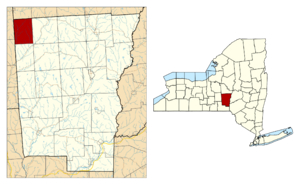
Lincklaen is a small town located in Chenango County, New York. In 2020, about 362 people lived there. The town was named after Colonel John Lincklaen, who was an important land owner. You can find Lincklaen in the northwestern part of Chenango County. It's northwest of the city of Norwich and northeast of Cortland.
Contents
History of Lincklaen
People first started settling in the area around Lincklaen in 1796. The town of Lincklaen was officially created in 1823. It was formed from a part of another town called German. Later, in 1827 and 1833, some parts of Lincklaen were used to create the town of Pitcher. In 1865, the population of Lincklaen was 988 people.
Geography of Lincklaen
Lincklaen covers a total area of about 68 square kilometers (26.27 square miles). Most of this area is land, with only a tiny bit being water.
The northern border of Lincklaen touches Madison County. The western border is next to Cortland County.
An important stream called Mud Creek flows south through the town. This creek eventually connects to the Otselic River, then the Tioughnioga River, and finally the Chenango River. All these rivers are part of the larger Susquehanna River system, which flows into the Chesapeake Bay.
People of Lincklaen
| Historical population | |||
|---|---|---|---|
| Census | Pop. | %± | |
| 1830 | 1,425 | — | |
| 1840 | 1,249 | −12.4% | |
| 1850 | 1,196 | −4.2% | |
| 1860 | 1,094 | −8.5% | |
| 1870 | 926 | −15.4% | |
| 1880 | 901 | −2.7% | |
| 1890 | 726 | −19.4% | |
| 1900 | 646 | −11.0% | |
| 1910 | 570 | −11.8% | |
| 1920 | 532 | −6.7% | |
| 1930 | 447 | −16.0% | |
| 1940 | 397 | −11.2% | |
| 1950 | 341 | −14.1% | |
| 1960 | 364 | 6.7% | |
| 1970 | 414 | 13.7% | |
| 1980 | 473 | 14.3% | |
| 1990 | 486 | 2.7% | |
| 2000 | 416 | −14.4% | |
| 2010 | 396 | −4.8% | |
| 2020 | 362 | −8.6% | |
| U.S. Decennial Census | |||
In 2020, the town of Lincklaen had 362 residents. There were 145 homes where people lived. The population density was about 15.8 people per square mile.
Most of the people in Lincklaen, about 89.5%, were White. A small percentage were Native American or from other racial backgrounds. About 2.76% of the population identified as Hispanic or Latino.
About 15% of the people in Lincklaen were under 18 years old. Many households, about 60%, were married couples or people living together. The average household had about 2.45 people.
The median income for a household in Lincklaen was $62,000. This means half of the households earned more than this, and half earned less. For families, the median income was $76,250. About 9.9% of the population lived below the poverty line.
Communities and Locations
Lincklaen has several small communities and areas within its borders:
- Burdick Settlement – This was a community that used to exist in the northern part of the town.
- Lincklaen – This is the main hamlet (a small village) of Lincklaen. It's located near the western edge of the town, along Mud Creek and County Road 12.
- Lincklaen Center – Another hamlet, found northeast of the main Lincklaen hamlet. It's also located on Mud Creek.
- Mariposa – This hamlet is east of Lincklaen Center. It's close to the eastern border of the town, on County Road 13.
- Rhode Island – A hamlet situated right at the eastern town line, also on County Road 13.
See also
 In Spanish: Lincklaen (Nueva York) para niños
 | Valerie Thomas |
 | Frederick McKinley Jones |
 | George Edward Alcorn Jr. |
 | Thomas Mensah |


