
Beaverkill Bridge facts for kids
Quick facts for kids Beaverkill Bridge |
|
|---|---|

Bridge from east side of stream, 2008
|
|
| Coordinates | 41°58′53.6″N 74°50′10.2″W / 41.981556°N 74.836167°W |
| Carries | |
| Crosses | Beaver Kill |
| Locale | Beaverkill, NY, USA |
| Other name(s) | Conklin Bridge |
| Maintained by | Town of Rockland |
| Heritage status | NRHP# 07001038 |
| ID number | 000000003357260 |
| Characteristics | |
| Design | Covered lattice truss bridge |
| Total length | 98 feet (30 m) |
| Width | 13 feet (4.0 m) |
| Height | 11+1⁄2 feet (3.5 m) |
| Load limit | 3 tons (2.7 tonnes) |
| Clearance above | 6 feet 6 inches (1.98 m) |
| History | |
| Construction end | 1865 |
| Statistics | |
| Daily traffic | 80 |
The Beaverkill Bridge, also known as the Conklin Bridge, is a historic wooden covered bridge. It crosses the Beaver Kill river in the Catskill Mountains of New York, USA. This bridge is special because it carries Conklin Road through the Beaverkill State Campground. It was built way back in 1865. At that time, this area was mostly wild and unsettled.
The bridge uses a unique design called a lattice truss bridge. This design was made popular by Ithiel Town in the 1800s. There's a bit of a mystery about who exactly built the bridge. It's possible that several people worked on it together. The Beaverkill Bridge is one of only 29 historic covered bridges left in New York State. In 2007, it was added to the National Register of Historic Places. This means it's recognized as an important historical site.
Contents
What Does the Bridge Look Like?
The Beaverkill Bridge is found along Campsite Road (County Route 30). It's in an area with a popular public campground. This campground is one of the oldest in the Catskill Park. The bridge crosses the Beaver Kill river, which flows south here. The area around the bridge is very green with lots of trees.
How Big Is the Beaverkill Bridge?
The bridge is about 98-foot (30 m) long. It is made mostly of hemlock wood. It rests on stone supports called abutments, which have concrete on their outer surfaces. On the east side, a short ramp leads up to the bridge. This ramp is supported by a strong steel beam.
Inside the Bridge's Structure
The bridge deck, where cars drive, is made of planks and is 13 feet (4.0 m) wide. It's held up by several wooden beams. The sides of the bridge have vertical wooden boards and a pointed metal roof. The roof is about 11+1⁄2 feet (3.5 m) high. Inside, the bridge is only about 6+1⁄2 feet (2.0 m) tall. Metal bars are placed near the entrances to stop tall vehicles from trying to cross.
The main parts of the bridge's structure are two sets of thick wooden planks. These planks form the top and bottom supports. Many diagonal wooden pieces, about 12 inches (30 cm) wide, connect these supports. They are held together by strong wooden pegs. There are also extra diagonal pieces at the ends of the bridge. These help spread out the weight of vehicles. This design is special for New York bridges.
History of the Beaverkill Bridge
The Beaverkill Bridge was an important step in developing this remote area. It helped connect the small town that grew around it. Even after the town became less busy, the bridge remained. In the mid-1900s, there was a plan to replace it. But local people worked hard to save it. Since then, the bridge has been repaired many times.
Early Days: A Tannery Town (1865–1880s)
For a long time in the 1800s, northern Sullivan County was mostly wild. This was partly because of land ownership disputes and the rugged land. Only loggers and hunters visited the remote Beaverkill valley. In 1832, a tannery was built near where the bridge is now. Tanneries used the bark from many hemlock trees to make tannin for leather. A small village called Beaverkill grew around this tannery.
The bridge was built in 1865. By 1872, the village had about a hundred people, a school, and a post office. It's believed that a bridge existed before this one, but there are no clear records.
Who Built the Bridge?
For many years, people in the area said that John Davidson built the bridge. He was a Scottish immigrant who lived nearby. His son, J.D. Davidson, wrote in 1942 that his father built this bridge and two others.
However, in the 1970s, some of John Davidson's relatives said his younger brother, Thomas, built it. Another record from 1895 gives credit to James Coulter for building the Beaverkill bridge. Coulter was a carpenter who had moved on from bridge building by 1859.
It's very likely that all three men had some part in building the bridge. On a big project like this, many skilled local people would probably have worked together.
The Bridge's Unique Design
The Beaverkill Bridge uses a lattice truss design. This design was patented by Ithiel Town in 1820. Its special feature is the diagonal pieces connected by pins. This design was popular during the American Civil War. The Beaverkill Bridge is one of the last bridges built with this specific design.
A key difference from Town's original plan is the extra diagonal pieces at the ends. These help spread the weight better. This special technique was likely not invented by the bridge's builder. But it is very rare for bridges in New York. The three bridges built by the Davidson family are the only ones known to use this design in the state.
A Community Landmark (1880s–Present)
The Beaverkill Bridge first appeared on local maps in 1875. After the 1880s, the tannery business declined. This was because most hemlock trees were gone, and new ways to make tannin were found. Instead, people started visiting the area for its beautiful scenery. The state also created the Forest Preserve to protect the land.
The Beaverkill river became popular for dry-fly fishing for trout. As more people visited, the state began building campgrounds in the 1920s. The area around the Beaverkill Bridge became the second public campground in the Catskill Park. Workers from the Civilian Conservation Corps improved the campground in the late 1930s. It became a model for other state campgrounds.
In 1948, the town wanted to replace the bridge with a new metal one. But local citizens worked to save it. Instead of tearing it down, the town spent $700 (which is like $9,000 today) to fix it. The bridge's ownership was then given to the county. Over the years, the county has made repairs, including adding concrete to the stone supports. This is the only major change to the bridge's look since it was built.
In the late 1990s, the bridge was studied for the Historic American Engineering Record. At first, the county was against listing it on the National Register. They worried it would make repairs harder or more expensive. Today, the bridge has height and weight limits to keep it safe.
The Beaverkill Bridge is very important for local residents. It's one of only two crossings for people living on the north side of the river. Both bridges are old and have reduced weight limits. This means heavier emergency vehicles might not be able to use them. In 2000, the state began looking into ways to solve this problem. In 2008, the bridge was closed for repairs, causing a three-mile detour. A federal grant in 2009 helped pay for more repairs.
Images for kids
-
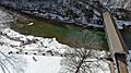
Aerial View of Beaverkill Covered Bridge

