Southwest Hunter Mountain facts for kids
Quick facts for kids Southwest Hunter Mountain (Leavitt Peak) |
|
|---|---|

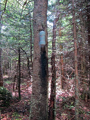
Summit canister
|
|
| Highest point | |
| Elevation | 3,750 feet (1,140 m) |
| Prominence | 200 ft (60 m) |
| Listing | Catskill High Peaks 15th |
| Geography | |
| Location | Hunter, Greene County, New York |
| Parent range | Devil's Path |
| Topo map | USGS Hunter |
Southwest Hunter Mountain, also known as Leavitt Peak, is a smaller peak next to the main Hunter Mountain in Greene County, New York. Even though it's a "subpeak" (a peak that is part of a larger mountain), it's considered important enough to be one of the Catskill High Peaks. This is because it stands out clearly from the main summit and the land around it. Hunter Mountain itself is named after John Hunter, who also gave his name to the nearby town of Hunter.
Contents
About Southwest Hunter Mountain
Southwest Hunter Mountain is part of the Devil's Path mountain range in the Catskill Mountains. To its northeast is the main summit of Hunter Mountain. To its west, it faces West Kill Mountain across a deep valley called Diamond Notch.
Getting to the Summit
There are no official, marked trails that lead to the top of Southwest Hunter Mountain. Because of this, reaching the summit is considered a "bushwack." This means hikers must make their own way through the woods, often without a clear path.
However, there is a faint "herd path" (an unofficial trail made by animals or repeated human use) that can help. This path starts about 0.1 miles (160 m) west of the Devil's Acre Lean-to. It's marked by a small pile of rocks, called a cairn. The path follows the ridge for about three-quarters of a mile. Then, it turns uphill towards the peak. This uphill turn can be easy to miss, as it's only marked by an arrow scratched onto a nearby rock.
Water Flow from the Mountain
Southwest Hunter Mountain is part of the watershed of the Hudson River. A watershed is an area of land where all the water drains into a single river or body of water. All the water flowing from Southwest Hunter Mountain eventually makes its way to the Hudson River, which then flows into New York Bay.
- The north side of Southwest Hunter Mountain drains into the very beginning, or headwaters, of the West Kill. This water then flows into Schoharie Creek, then the Mohawk River, and finally the Hudson River.
- The southeast slopes of the mountain drain into a stream called Myrtle Brook. This water then goes into Stony Clove Creek, then Esopus Creek, and finally the Hudson River.
- The southwest side of Southwest Hunter Mountain drains into Hollow Brook, which also flows into Stony Clove Creek.
Protecting the Mountain
Hunter Mountain, including Southwest Hunter, is located within the Hunter Mountain Wild Forest. This area is part of New York's Catskill State Park. These areas are protected to preserve their natural beauty and wildlife.
Naming the Peak
Currently, Southwest Hunter Mountain does not have an official name in the government's database of geographic names (GNIS). However, there is an effort to officially name the peak "Leavitt Peak." This would be in honor of Bill and Elinore Leavitt. They were two of the people who helped start the Catskill 3500 Club. This club is for hikers who have climbed all 35 peaks in the Catskills that are over 3,500 feet tall.
 | Emma Amos |
 | Edward Mitchell Bannister |
 | Larry D. Alexander |
 | Ernie Barnes |

