Stony Clove Creek facts for kids
Quick facts for kids Stony Clove Creek |
|
|---|---|

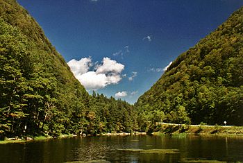
A photograph of Notch Lake near the Stony Clove Notch. It is the beginning of the Stony Clove Creek.
|
|
|
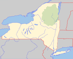
Location of the mouth of Stony Clove Creek
|
|
| Country | United States |
| State | New York |
| Region | Catskill Mountains |
| Counties | Ulster, Greene |
| Towns | Hunter, Shandaken |
| Physical characteristics | |
| Main source | Notch Lake Stony Clove Notch, N of Edgewood, New York, U.S. 1,980 feet (600 m) 42°09′34″N 74°12′15″W / 42.1595332°N 74.2040319°W |
| River mouth | Esopus Creek Phoenicia, New York, U.S. 804 ft (245 m) 42°04′53″N 74°18′52″W / 42.0814794°N 74.3143143°W |
| Length | 10.3 mi (16.6 km) |
| Basin features | |
| Basin size | 32.4 square miles (83.9 km2) |
| Tributaries |
|
Stony Clove Creek is a cool, 10.3-mile-long (16.6 km) stream flowing through the beautiful Catskill Mountains in New York State. It's like a smaller river that eventually joins a bigger one called Esopus Creek. The Esopus Creek then flows into the mighty Hudson River. You can find Stony Clove Creek joining the Esopus in a village called Phoenicia. It also has a couple of smaller streams that flow into it further north.
Contents
Where the Creek Flows
The Stony Clove Creek begins its journey near a place called Stony Clove Notch in Edgewood, which is in Greene County. Its very start is at Notch Lake, close to the Devil's Tombstone Campsite.
From there, the creek flows through small villages like Edgewood and Lanesville. It then enters Ulster County when it reaches Chichester.
How the Creek Was Formed
Stony Clove Creek was created about 10,000 years ago. This was during the last Ice age, a time when huge sheets of ice covered much of the Earth.
As the ice melted, a lot of water burst through the area where the Stony Clove Notch is now. This flood of water rushed down a valley that was already carved out, forming the small river we see today.
Water Levels and Flow
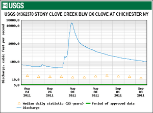
Scientists from the United States Geological Survey (USGS) keep track of the water levels in Stony Clove Creek. They have special equipment called stream gauges that measure how much water is flowing.
One station in Chichester, about 1.8 miles (2.9 km) upstream from where the creek meets the Esopus, has been recording data since 1997. The most water ever recorded there was 14,300 cubic feet (400 m3) per second on August 28, 2011. This happened when Hurricane Irene, a very strong storm, passed through the area. The least amount of water recorded was 3.1 cubic feet (0.088 m3) per second on October 3, 2014.
Stony Clove Creek is known for adding a lot of cloudiness and tiny bits of dirt (called sediment) to the upper part of Esopus Creek. It actually adds more cloudiness than all the other streams in that area combined!
Streams Joining Stony Clove Creek
Many smaller streams, called tributaries, flow into Stony Clove Creek along its path. These include:
- Ox Clove Brook
- Warner Creek
- Hollow Tree Brook
- Lanes Hollow Brook
- Rhine Hollow Brook
- Fenwick Brook
- Christine Brook
 | Shirley Ann Jackson |
 | Garett Morgan |
 | J. Ernest Wilkins Jr. |
 | Elijah McCoy |


