Stony Clove Notch facts for kids
Quick facts for kids Stony Clove Notch |
|
|---|---|

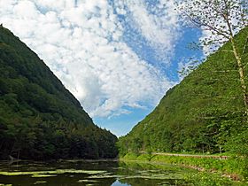
Stony Clove Notch behind Notch Lake.
|
|
| Elevation | 2,220 ft (677 m) |
| Traversed by | |
| Location | Town of Hunter, Greene County, New York, United States |
| Range | Catskills |
| Coordinates | 42°09′54″N 74°12′06″W / 42.16500°N 74.20167°W |
| Topo map | USGS Hunter |
Stony Clove Notch is a narrow mountain pass in the Catskill Mountains of New York State. It's about 2,220 feet (677 meters) high. This special spot is found in the Town of Hunter, in Greene County.
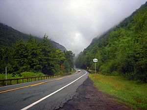
The notch is a deep gap between two large mountains: Hunter Mountain and Plateau Mountain. There's just enough space for New York State Route 214 to pass through. In the past, a railroad also used this route. The steep sides of the mountains here are very dramatic, with visible rock cliffs and places where landslides have happened. It's also at one end of a famous hiking area called the Devil's Path. Early visitors found this place quite scary!
Today, Stony Clove Notch is a popular spot for both tourists and outdoor adventurers. A major hiking trail in the Catskills crosses the road right near the notch. In winter, people who love ice climbing and snowboarding come to enjoy the cliffs and slopes.
Contents
How Stony Clove Notch Was Formed
Nature's Work: The Ice Age Story
Stony Clove Notch was created a very long time ago. This happened at the end of the last Ice Age. Huge amounts of meltwater from the ice built up to the north. This water slowly carved its way through the gap between Hunter and Plateau mountains. Over time, this powerful water formed the Stony Clove Creek and the notch we see today.
How People Used the Notch Over Time
When the first Europeans explored this area, the notch was so narrow that people could only walk through it in a single line. It was a wild and lonely place. A writer named Charles Lanman described it in the 1840s as "the loneliest and most awful corner of the world."
Later, people worked hard to make the notch easier to travel through. A local tanner named Charles Edwards spent a lot of money to widen the path for wagons. Even later, a narrow gauge train track was built through the gap. This track was later made wider and used until 1940. You can still see parts of the old railroad path in the woods today.
In 1873, a private company called the Stoney Clove Turnpike was formed. They improved the wagon road, which eventually became today's Route 214.
Exploring the Geography of the Notch
Stony Clove Notch is important because it divides two main water areas. These are the Schoharie and Esopus sub-watersheds, both part of the larger Hudson River basin.
Approaching from the North
If you come from the north, from the Schoharie area, you'll see the two mountains getting bigger and bigger. They seem to almost "swallow" the road as you drive higher. Some people say that coming this way during a thunderstorm helps you understand how scary early visitors found the notch. The sound of lightning and thunder bouncing between the mountains can be very dramatic!
Approaching from the South
Coming from the south, near Phoenicia, is a bit less dramatic. You won't see Hunter and Plateau mountains until you are much closer to the notch. However, this route offers beautiful forest scenery. The road winds along the Stony Clove Creek, slowly gaining height. You'll pass the Devil's Tombstone campground, and then the notch becomes clear as you drive by Notch Pond and up to the highest point.
Nature and Wildlife in the Notch
Stony Clove Notch is special because it has a type of forest called boreal forest at a lower elevation than usual. This is rare in the Catskills. In 1893, large forest fires burned about 3,000 acres around the notch. These fires, along with the steep land, left thin soils. Because of this, you can see trees like balsam fir and red spruce growing here. These trees are usually found in colder, northern climates. You'll also see paper birch trees, which are common in boreal forests.
Most of the land around the notch is protected. It's part of the Catskill Park and New York's Forest Preserve. The land on the Plateau side is part of the Indian Head Wilderness Area. The Hunter side is currently called the Hunter Mountain Wild Forest. However, there are plans to make it a wilderness area too, which means it will be even more protected.
Fun Activities at Stony Clove Notch
Hiking Adventures
There's a parking lot next to Notch Pond, right where the famous Devil's Path hiking trail crosses the road. This is the only place the Devil's Path crosses a road in its entire 24.2-mile (39 km) length! Many hikers start here to reach the nearby high peaks like Plateau, Hunter, and Southwest Hunter. There are water pumps available for hikers and visitors to use.
- Climbing Plateau Mountain: The hike up Plateau Mountain gives you amazing views of the notch. After crossing an old railroad path, the trail climbs steeply for about 1,400 feet (427 meters). You'll reach a popular viewpoint called Orchard Point. From here, you can see across the notch to all the nearby peaks. After that, it's about two miles (3.2 km) across the flat top of Plateau Mountain to its summit.
- Exploring Hunter Mountain: The climb up Hunter Mountain from the notch is not as steep in some parts. There's a famous spot called the Devil's Portal. While there aren't many wide views on this trail, there's a nice flat section that leads to the Devil's Acre Lean-to. From there, the Hunter Mountain Trail goes to the top of the Catskills' second-highest peak.
The Long Path trail also joins the Devil's Path here for a while. Future plans will move this trail deeper into the forest, away from the road.
Winter Sports and More
In winter, ice climbers come to the cliffs on the Plateau side for exciting climbs. Snowboarders also find challenging runs on the slopes.
 | Dorothy Vaughan |
 | Charles Henry Turner |
 | Hildrus Poindexter |
 | Henry Cecil McBay |


