Long Path facts for kids
Quick facts for kids Long Path |
|
|---|---|
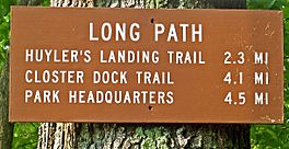
Long Path mileage sign in Palisades Interstate Park
|
|
| Length | 357 mi (575 km) |
| Location | New Jersey and New York, United States |
| Designation | National Recreation Trail (parts) |
| Trailheads | 175th Street subway station, New York, NY John Boyd Thacher State Park, New York |
| Use | Hiking |
| Highest point | Slide Mountain |
| Lowest point | Sparkill Creek |
| Difficulty | Moderate to strenuous |
| Sights | New Jersey Palisades, Harriman State Park, Schunemunk Mountain, Shawangunk Ridge, Catskill Mountains, Vroman's Nose |
The Long Path is a super long hiking trail that stretches for about 357 miles (575 km). It starts near the George Washington Bridge in Fort Lee, New Jersey. The trail then goes all the way to Altamont, New York, near the city of Albany.
Even though some parts of the trail use roads, it connects many cool hiking spots. These include the New Jersey Palisades, Harriman State Park, the Shawangunk Ridge, and the Catskill Mountains. Hikers get to see many different environments. You can walk through suburbs and salt marshes near the Hudson River. You can also explore wild areas and cool boreal forests on top of Catskill mountains, some as high as 4,000 feet (1,200 m).
The idea for the Long Path started in the 1930s. It was meant to be a different kind of trail. There would be no marked route or special signs. Instead, it was a list of interesting places. Hikers would find their own way between them. But after World War II, more buildings were put up in Orange and Rockland counties. This made the original idea hard to follow. So, in the 1960s, the Long Path became a regular marked trail. There are plans to make it even longer. It might go through the Adirondack Mountains all the way to the Canadian border!
Contents
Exploring the Long Path's History
How the Long Path Began
Vincent Joseph Schaefer, a scientist from Schenectady, New York, had a big idea in 1929. He imagined a "hiker's route" from New York City to the Adirondacks. He wanted it to be a wild walk, not a marked trail. Schaefer thought hikers should use their own skills. They would use a compass and maps to find cool spots. These spots included great views, rock formations, and historical places. He believed this way, the land would not be harmed. It would also keep the feeling of being truly wild.
He called his idea the Long Path. This name came from a line by the poet Walt Whitman. Raymond H. Torrey, a famous hiking writer, loved the idea. He wrote about it in his newspaper column in 1933. Torrey had helped build the Appalachian Trail. So, his support was very important.
Building the Trail Over Time
Schaefer and Torrey explored parts of the route. They mapped out a "trail" from the city to the Catskills. Schaefer also explored the northern half. At first, the trail was just an idea on a map. But most hikers wanted a clear path to follow. So, the original idea of an unmarked trail faded away.
In 1960, two hikers, Robert Jessen and Michael Warren, brought the idea back. They decided the Long Path needed to be a normal, marked trail. This was because more land was being developed. Over the next 20 years, they created a continuous trail. It went from the George Washington Bridge to the southern Catskills. By 1987, the Catskill part was finished.
In 1991, Vince Schaefer wrote a guide for the northern part of the Long Path. It listed 80 "Landmarks" with map locations. His son, James M. Schaefer, helped continue this work. He used his father's notes to help mark the trail. They used GPS and digital photos for the landmarks.
Today, the Long Path is a mix of different types of trails. About 357 miles (575 km) are marked for traditional hikers. There are also about 100 miles (160 km) of road walks. These are good for people who might find rough trails too hard. The last 150 miles (240 km) are bushwhacks. This means hikers use maps and compasses to find their way. This part keeps Vince Schaefer's original idea alive.
Making the Trail Longer
In 1985, people wanted to connect the Long Path to the Adirondacks. The Long Path North Hiking Club was formed. By 1990, 8 miles (13 km) of new trail were opened. By the mid-1990s, the trail reached John Boyd Thacher State Park. This was 75 miles (120 km) north of its old end point. More sections were added in the early 2000s.
The Long Path Today
The Long Path is always changing and getting better. New sections are opened, and old ones are moved. This makes the trail even more enjoyable.
Many changes have happened in the central Catskills. New trail sections have been built. For example, a section near Mount Tremper was completed in 1999. This helped hikers avoid a long walk on a road. Another new section connects Silver Hollow Notch to Plateau Mountain. This means hikers can now walk 23 miles (37 km) without crossing any roads!
The state also bought land near Kerhonkson. This new land will help move the Long Path off roads. It will follow the Vernooy Kill instead. In 2001, a new trail was built across the Platte Clove Preserve. This added Indian Head Mountain to the route. It also gave hikers amazing views of the Hudson Valley.
South of Phoenicia, a new section opened in 2014. It goes over Cross Mountain, Mount Pleasant, and Romer Mountain. This removed a long road walk from Woodland Valley State Campground. All these changes mean that almost all of the 94 miles (151 km) of the Long Path in the Catskill Park are now off-road.
In the Shawangunks, new agreements have also helped remove road walks. In Rockland County, which has many suburbs, the county is working to protect the trail. They want to keep the Long Path as a green space.
North of the Catskills, the Long Path North Committee is still working. They want to move the trail off roads and into more wooded areas. The main challenge there is that not enough people use some sections. This means parts of the trail can get overgrown. So, they are trying to make more people aware of the trail.
In 2015, the southern end of the trail moved. It now starts in New York City, at the 175th Street subway station in Manhattan.
The Orange County Challenge
Getting the trail across northern Orange County has always been tricky. This area has many farms and is now very developed. But there has been good progress! In 2012, almost half of the 35 miles (56 km) of road walking in Orange County were removed. The Long Path now uses the Heritage Trail, which is an old rail line. This part of the trail is even good for bicycling!
There is hope to move even more of the trail off roads. They are looking at farms, town parks, and old rail beds.
The Shawangunk Ridge Trail Option
To avoid the Orange County problem, another option was created. It's called the Shawangunk Ridge Trail (SRT). This 71-mile (114 km) trail starts at the Appalachian Trail in New Jersey. The Long Path joins the SRT after 11.25 miles (18 km). They run together for the next 34 miles (55 km). This detour is recommended for people who want to hike the entire Long Path. It has more places to camp and fewer road walks. But if you are doing day hikes, it's best to stay on the main Long Path. That way, you won't miss parts of Harriman State Park or Schunemunk Mountain.
Who Manages the Long Path?
The New York–New Jersey Trail Conference oversees the Long Path. They divide it into three parts:
- The Long Path South Committee for areas south of the Catskills.
- The Catskill Trails Committee for the Catskills.
- The Long Path North Committee for the northern parts.
The Long Path North Committee works a bit on its own. This is because its area is far from the Trail Conference's main base. In the future, if the trail goes into the Adirondacks, another group might help manage those parts.
How the Long Path Is Marked
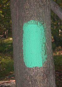
Most of the Long Path is marked with a 2 by 4 inch (5 by 10 cm) aqua-colored blaze. Aqua is a special blue-green color. Sometimes you might see older light blue blazes. But the aqua color always means you are on the Long Path.
In the Catskills and state forests, the trail uses official markers. These are blue in the Shawangunks. In the Catskills, they use whatever color is for that specific trail. You might also see signs with the Long Path logo at trail crossings.
A section through the Catskill Center's Platte Clove Preserve uses green diamond-shaped metal markers. The section in Thacher State Park uses aqua plastic markers with the LP logo. The Shawangunk Ridge Trail uses aqua blazes or blue markers. This depends on if it's on public or private land.
Hiking the Entire Long Path
When the Long Path was first made, it wasn't really for hiking the whole thing at once. It was more for day trips or short overnight hikes. But some people wanted to hike the entire trail!
On May 30, 1998, Mary Ann Nissley became the first person to hike the entire Long Path. She finished it in 25 days. Since then, several others have also completed the whole trail.
The Long Path guidebook now helps thru-hikers. It has information about nearby post offices and places to stay.
On May 24, 2005, David O'Neill became the first person to run the entire Long Path. He did it in 24 days! He even repeated the run in 2006. That time, he used the AT-SRT detour. He finished the 369-mile (594 km) journey in just 12 days, 5 hours, and 17 minutes.
In 2009, Jacob Aronson hiked from the George Washington Bridge to Whiteface Mountain. This was Vince Schaefer's original dream! He finished the Long Path part in 27 days. Then he continued to Whiteface Mountain, finishing his whole journey in 46 days.
In 2013, Daniel J. Rosenthal was the first to hike the trail going south. Later that year, Kenneth Posner ran the entire trail in just nine days. This is the current record! He mostly carried his own supplies and slept along the trail.
The Long Path Route: What You'll See
From Fort Lee to Harriman State Park
The Long Path starts in Fort Lee, New Jersey. It crosses a pedestrian bridge and enters Palisades Interstate Park. For about 12.7 miles (20 km), it follows the cliffs. You'll walk through woods and past rest stops.
After the state line, the trail briefly goes back into New Jersey. Then it heads towards Tallman Mountain State Park. It climbs Tallman Mountain and then drops to its lowest point. This is only 5 feet (1.5 m) above sea level at Sparkill Creek.
The trail crosses Route 9W again and goes through hills. It passes Blauvelt State Park and drops into Nyack. Here, it crosses the New York State Thruway. After a county park, it follows Route 9W for a bit. Then it enters Hook Mountain State Park. This park has amazing views over the Hudson River.
Next, it drops to Haverstraw Beach State Park. It then follows a road into High Tor State Park. The top of High Tor is the highest point of the Palisades. It offers the best views of this part of the Hudson Valley.
After High Tor, the trail stays on a ridge. It crosses the Palisades Parkway, US 202, and NY 45. The trail then follows the parkway's edge. Finally, it enters Cheesecote Town Park. A short road walk leads to Harriman State Park.
From Harriman to the Shawangunks
The trail winds through the southern part of Harriman Park. It briefly joins the Suffern-Bear Mountain Trail. It passes St.-John's-in-the-Wilderness Church. Then it reaches Seven Lakes Drive at Lake Skannatati. North of there, it joins the Dunning Trail. You'll see old iron mine ruins. It crosses the Appalachian Trail. Then it continues north to the Lake Cohasset Shelter, where you can camp.
The trail runs along Stockbridge Mountain. It passes the Stockbridge and Stockbridge Cave Shelters. Then it goes down to US 6.
It climbs Long Mountain to a memorial for Raymond H. Torrey. He helped make the trail possible. The trail then heads west. It sometimes goes near the West Point property. It crosses NY 293 and follows Route 6. Finally, it leaves Harriman Park. It drops to local roads in the Central Valley area. It crosses the Thruway again. Then it follows Woodbury Creek to NY 32 and Schunemunk Mountain.
On Schunemunk, the trail climbs hills with great views. It follows the Jessup Trail southwest. You'll see amazing views across the Moodna and Wallkill valleys. Then it drops to Gonzaga Park. It passes the Orange and Rockland Lakes. It crosses Route 17 to the Heritage Trail. This old rail trail passes wetlands and farms. It goes through the historic village of Goshen. Leaving the rail trail, it follows back roads over the Wallkill River. It goes into the town of Wawayanda. After crossing I-84, the road walk ends at the Shawangunk Ridge. It crosses the ridge on a newly protected piece of land. Here, it joins the Shawangunk Ridge Trail.
Shawangunks and Southern Catskills
The trail stays on the west side of the ridgeline. It follows an old rail bed. Leaving the rail bed, it passes through a state forest. It crosses into Sullivan County. Here, it goes through the Bashakill Wildlife Management Area. The trail reaches the village of Wurtsboro. Then it climbs back up to the ridge. It mostly follows the ridge into Ulster County.
The trail briefly follows an old dirt road. It goes down toward South Gully. Then it climbs up to Sam's Point. It follows South Gully Brook at times. After old dirt roads, the trail goes through a dwarf pine forest. It leads to VerKeerderkill Falls. Many hikers love this section. The short trees make you feel like you are above the tree line. You get constant views of the ridge and valleys. The falls are also a unique sight. After the falls, the trail crosses High Point and Smiley Carriageway. Then it goes down to Berme Road.
After Berme Road, the trail follows the D & H Canal towpath. It goes to the hamlet of Port Ben. It crosses Rondout Creek and US 209. It follows quiet local roads to the Catskill Park Blue Line. Soon after entering the Catskills, it reaches the Vernooy Kill Falls. This is another popular spot. It then climbs over Bangle Hill. It goes down steeply to a state campground at Bull Run.
One of the hardest parts of the Long Path is next. It climbs over 2,600 feet (790 m) in 4 miles (6.4 km). This takes you to the top of Peekamoose Mountain. Then it crosses Table Mountain.
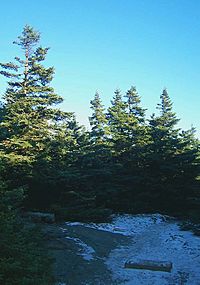
From there, it drops down to cross the East Branch of the Neversink River. Then it climbs slightly to a junction with the Phoenicia-East Branch Trail. It follows this trail up to a pass. Then it goes up the beautiful Curtis-Ormsbee Trail. This leads to the top of Slide Mountain. This is the highest peak in the Catskills. It's also the highest point on the Long Path, about 4,180 feet (1,270 m) high.
It then goes down over Cornell and Wittenberg mountains. It crosses Cross Mountain. Then it passes Mount Pleasant and Romer Mountain. Finally, it follows the road out to Phoenicia.
Central and Northern Catskills
Crossing NY 28 and going through Phoenicia, the Long Path follows a road east. It leads to the trailhead for Mount Tremper. Here, it follows an old road up to the fire tower. The tower offers amazing views of the whole area. Continuing down to Warners Creek, it goes up Edgewood Mountain. Then it drops down to Silver Hollow Notch. It joins the Devil's Path. This is a challenging trail in the Catskills. It follows the Devil's Path across Plateau, Sugarloaf, Twin, and Indian Head mountains. It goes down to the Platte Clove Preserve.
Then, there's a short road walk to the Kaaterskill High Peak snowmobile trail. On the north side of that peak, the Long Path goes down over 2,000 feet (610 m). It passes several waterfalls to Palenville. It crosses NY 23A. Then it goes back up the other side of Kaaterskill Clove. It follows the Old Overlook Road to the Escarpment Trail. This is where the famous Catskill Mountain House used to be. It passes North–South Lake State Campground. Finally, it goes up to North Mountain. This spot has inspiring views back over the Escarpment and the lakes.
Eventually, the trail reaches the top of 3,420-foot (1,040 m) Stoppel Point. There's an old wrecked plane nearby. Then it drops into Dutcher Notch. It goes back up to a ridge. This leads to a steep climb up Blackhead Mountain. This peak is 3,940 feet (1,200 m) high. Then it goes down to Acra Point, Burnt Knob, and finally Windham High Peak. This is the northernmost of the Catskill High Peaks. It goes down to NY 23. It leaves the Catskill Park but stays in the Catskills. It immediately goes over several 3,000-foot (910 m) peaks to Ashland Pinnacle.
The Long Path North
From Ashland Pinnacle, the trail uses roads, woodlots, and field edges. It goes to Schoharie Reservoir. It crosses the Schoharie Creek and enters Schoharie County. The first stop is Mine Kill State Park and its waterfall. Then the trail goes through woods to Lansing Manor. This is at the Blenheim-Gilboa Power Project. It continues through state forests like Burnt-Rossman Hills and Patria. Then it goes up NY 30 to Vroman's Nose. This is a popular local hike.
Afterwards, it crosses the Schoharie again into Middleburgh. It follows NY 145 briefly to climb the Middleburgh cliffs. Then it goes across Cotton Hill and Dutch Settlement state forests. It enters Albany County. Here, it goes through the Partridge Run Wildlife Management Area and Cole Hill State Forest. It also follows the Helderberg Escarpment. This leads through John Boyd Thacher State Park, with its Indian Ladder.
Currently, Thacher State Park is the end of the trail for people hiking the whole thing. But a route has been marked across the Mohawk River to the Saratoga County line. From there, a road walk is described to the Northville-Placid Trail inside the Adirondack Park.
 | Janet Taylor Pickett |
 | Synthia Saint James |
 | Howardena Pindell |
 | Faith Ringgold |


