Mount Tremper facts for kids
Quick facts for kids Mount Tremper |
|
|---|---|
| Timothyberg, Tremper Mountain | |

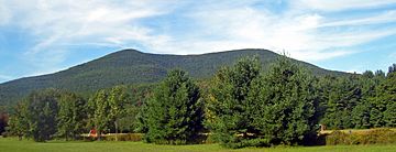
Mount Tremper from Route 28 to southeast
|
|
| Highest point | |
| Elevation | 2,740 ft (840 m) |
| Prominence | 300 ft (91 m) |
| Geography | |
| Location | Shandaken, New York, United States |
| Parent range | Catskills |
| Topo map | Phoenicia |
| Climbing | |
| Easiest route | Trail/road |
Mount Tremper is a cool mountain in the Catskill Mountains of New York State. It's also known as Tremper Mountain and used to be called Timothyberg. You can find it near the small town of Phoenicia, right by the Esopus Creek.
This mountain is about 2,740 feet (835 meters) tall. That's not as high as some other peaks in the Catskills. Long ago, in the 1800s, people used Mount Tremper for two main things. They harvested hemlock trees for their bark, which was used to make leather. They also dug up "bluestone," a type of rock used for building.
Later, a famous hotel called Tremper House was built here. Important people like Henry Ward Beecher and Oscar Wilde even stayed there!
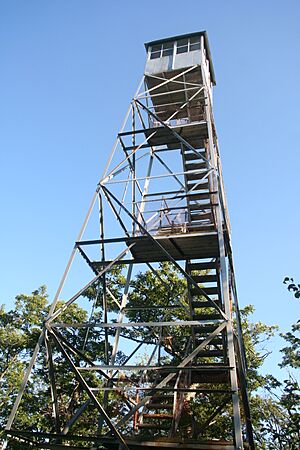
In the 1900s, the state bought the mountain. It became part of the Catskill Park Forest Preserve. Because of its great location, a fire lookout tower was built on top. This tower helped spot forest fires. Today, the Mount Tremper Fire Observation Station has been fixed up. It is now listed on the National Register of Historic Places. Many hikers love to walk up the old road to the tower from Phoenicia. It's also part of the Long Path hiking trail. From the tower, you can see amazing views!
Contents
Exploring Mount Tremper's Location
Mount Tremper is a wide mountain at the southern end of a group of smaller peaks. It's surrounded by several creeks. These include Warners Creek, Silver Hollow, Stony Clove Creek, and Esopus Creek. State roads like Route 214, Route 28, and Route 212 run close by. When you drive west on Route 28, Mount Tremper is the big mountain you see from the small town of Mount Tremper.
The bottom parts of the mountain are gentle slopes. But around 2,200 feet (670 meters) up, it gets steeper. Then, it flattens out again at the top. Small streams flow down the mountain's sides. The top ridge of Mount Tremper continues northeast to other peaks like Carl Mountain, which are even taller.
Most of Mount Tremper is in the town of Shandaken. The biggest town nearby, Phoenicia, is at the mountain's base. A small part of the mountain's eastern side is in Woodstock. Most of the land on the mountain is public land. It's part of the Phoenicia Wild Forest and the Catskill Park. The rest of the mountain, especially the lower slopes, is privately owned. The state Department of Environmental Conservation (DEC) manages the public land.
How Mount Tremper Was Formed
Like all the Catskill Mountains, Tremper was not formed by rocks pushing up. Instead, it was shaped by streams slowly wearing away the land. This happened about 350 million years ago. The rocks you find on Mount Tremper are mostly shale and sandstone.
There was once a quarry on the south side of the mountain. This is where people dug up bluestone. You can still see what's left of this quarry today from the old road that leads to the fire tower.
Plants and Animals of Mount Tremper
Because Mount Tremper is not super high, its forests are mostly "southern hardwoods." These forests have lots of oak, hickory, and pine trees. You might also see some basswood and poplar trees. Chestnut trees used to be common. But most of them died from a disease in the early 1900s.
Some hemlock trees still grow here. They were once cut down for their bark, which was used to make leather. But some remained higher up the mountain where people couldn't reach them. The very top of the mountain has some "northern hardwood" forests. These have beech, birch, and maple trees.
Mount Tremper has many common Catskill animals. You might see white-tailed deer, chipmunks, and porcupines. For predators, there are fishers and black bears. The old quarry area is home to some rattlesnakes. Hikers should be careful if they explore this spot.
Mount Tremper's History
Mount Tremper's story has two main parts. For about 100 years, it was important for different businesses. After that, it became a popular place for outdoor fun.
Early Days: Bark, Stone, and Hotels (1780-1900)
The mountain was first called Timothyberg by the early Dutch settlers. People started living in this area in the 1780s. The mountain was perfect for "barkpeeling." This was the first big business in the Catskills. The bark from the many hemlock trees on the mountain had a lot of "tannin." This was used to tan leather. It was easy to move the leather and bark using the nearby creeks. Later, the Ulster and Delaware Railroad made it even easier. The old road up the south side of the mountain was built for this bark business.
By the late 1800s, people found a new way to make tannin. So, the bark business slowed down. Instead, people started quarrying bluestone from the mountain.
The railroad also helped a new business grow. In 1879, a hotel owner named Jacob Tremper opened the Tremper House. It was a resort on the mountain near Phoenicia. This is how the mountain got its name. Famous people like Henry Ward Beecher and Oscar Wilde visited the hotel. Oscar Wilde even said that hotels in valleys, like Tremper House, were better than those on mountaintops. He felt that in valleys, "the picturesque and beautiful is ever before you."
The Tremper House stayed open until 1904. Then, the town stopped it from becoming a hospital for people with tuberculosis. Other hotel owners worried that tourists would avoid the area if sick people were there. The empty hotel burned down in 1908 and was never rebuilt.
Around this time, a law was passed to create the state's Forest Preserve. This law said the land must stay "forever wild." The state bought the top of Mount Tremper and some other land in 1901. They tried to plant new trees there, but it didn't work very well. The land eventually grew back its own trees.
Modern Era: A Hiking Hotspot (1900-Present)
Before 1916, people used to burn the Timothyberg side of the mountain every year to help blueberries grow. But in 1916, the state built a 47-foot (14-meter) fire lookout tower on the mountain. They also made the old road better so fire observers could reach it. Mount Tremper was chosen for the tower because it offered great views of the lower areas. These views couldn't be seen from other fire towers on Hunter and Belleayre mountains.
In 1921, the state bought more land on the mountain. This allowed them to make the old road into a hiking trail. By 1931, the trail went past the tower and down the other side of the mountain to Willow. Later, in the 1930s, a small shelter called a lean-to was built at the top for backpackers to camp in.
The trail system stayed mostly the same for many years. A new part of the trail and a trailhead (where the trail starts) were built near Phoenicia. When the idea for the Long Path hiking trail came back in the 1960s, the trail over Mount Tremper was included. In 1966, a campfire caused a wildfire that burned 10 acres (4 hectares) near the top. Four years later, in 1970, the state closed the fire tower.
In 1976, the state bought more land along the trail. They built another lean-to at 2,100 feet (640 meters) along the trail. The next year, the tower's two support buildings were removed. These were the last big changes to Mount Tremper for about 20 years.
At the end of the 1900s, people wanted to fix up and save the fire tower. The DEC wanted to remove it, but local people raised money to save it. The tower reopened in spring 2001. It was listed on the National Register of Historic Places later that year. A new part of the Long Path was also opened that year. It goes along the ridge past Carl Mountain to Plateau Mountain.
Hiking Mount Tremper
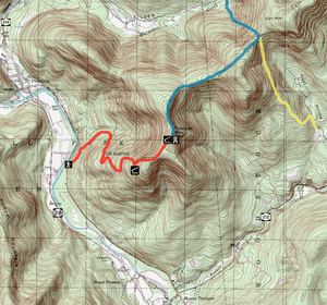
The Phoenicia Trail is a popular way to reach Mount Tremper's summit. It's part of the Long Path. This trail used to be the old road for barkpeelers. It starts 1.6 miles (2.6 km) south of Phoenicia. You'll find it across from the Esopus Creek.
The trail is marked with red plastic DEC markers. After about half a mile (1 km), it joins the old road. It then follows the road with several turns, passing the old quarry, a spring, the Baldwin Memorial Lean-To, and another spring. It reaches the lean-to and fire tower after 2.8 miles (4.5 km). You'll climb almost 2,000 feet (610 meters) from the start of the trail.
Another way to hike Mount Tremper is from the northeast, using the Willow Trail. This trail has yellow markers. It starts in Willow and follows Jessup Road for a mile (1.6 km). Then it goes into the woods and climbs for 1.5 miles (2.4 km). It ends at the blue-marked Warners Creek Trail, which is also part of the Long Path. From there, the summit and fire tower are 2.2 miles (3.5 km) to the south. This route is longer (3.8 miles or 6.1 km) but has less climbing (1,640 feet or 500 meters). Some hikers park cars at both Willow and Phoenicia. This lets them do a 7-mile (11.3 km) hike across the mountain.
The Warners Creek Trail also lets you approach the mountain from the north. This route starts at Stony Clove Notch. It's 7.6 miles (12.2 km) from the parking area to Mount Tremper's summit. This trail goes over one mountain and then up the north side of Tremper.
 | Jackie Robinson |
 | Jack Johnson |
 | Althea Gibson |
 | Arthur Ashe |
 | Muhammad Ali |


