
John Boyd Thacher State Park facts for kids
Quick facts for kids John Boyd Thacher State Park |
|
|---|---|

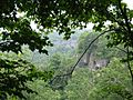
View from the overlook
|
|
| Lua error in Module:Location_map at line 420: attempt to index field 'wikibase' (a nil value). | |
| Type | State Park |
| Location | Albany County, New York, United States |
| Area | 2,155 acres (872 ha) |
| Created | 1914 |
| Operated by | New York State |
John Boyd Thacher State Park is a fun state park located about 15 miles (24 km) southwest of Albany, New York. It's near Voorheesville in Albany County. Most of the park sits high up on the Helderberg Escarpment. This means it has amazing hiking trails with wide-open views. You can see the Green Mountains in Vermont and the Taconic Mountains in the Hudson Valley.
Contents
Exploring Thacher Park


Thacher Park has lots to do! The famous Indian Ladder Trail is usually open from early summer to mid-November. It's open from 8:00 am until sunset, if the weather is good. All other trails in the park are open all year round.
The park is on the Helderberg Escarpment. This area is one of the best places in the United States to find fossils. There are more than 12 miles (20 km) of trails here. Besides hiking, you can find volleyball courts, play areas for kids, and many spots for cooking and barbecues. Some cooking areas are even covered!
Close by, at Thompson's Lake, you'll find the Emma Treadwell Thacher Nature Center. It opened in 2001 and has cool displays for everyone to see. The center also offers fun learning programs and helpful information for visitors.
From the top of the escarpment, which is about 1300 ft (400 m) high, you get fantastic views. You can see the Hudson and Mohawk Valleys. You can also enjoy amazing views of the Adirondacks and the Green Mountains of Vermont.
A Look Back: Park History
The story of Thacher Park goes back about 400 years. Back then, the trail we now call the Indian Ladder Trail was used by the Mohawk Iroquois Native Americans. They used it to reach a trading post run by the Dutch settlers.

In 1777, there was a special spot called Tory Cave. A man named Jacob Salsbury hid there from settlers during the Burgoyne Invasion.
The land around the park is mostly limestone. This means water drains away quickly, making it hard for farming. But some areas near streams were good for growing crops. Dutch settlers came to this region. They had to pay high rents to powerful landowners called Patroons. They finally broke free from these payments in the "Helderberg War" of 1839.
The park is named after John Boyd Thacher, who was the mayor of Albany. His wife, Emma Treadwell Thacher, gave the land for the park in 1914. Since it opened, the park has been a popular spot for people in Upstate New York. Many new things were added over time. The park grew bigger with more land purchases, reaching a total of 2,155 acres (8.72 km2).
The name "Helderberg Escarpment" likely comes from Dutch words. Helder means "bright" or "light," and Berg means "mountain." So, it's like "Bright Mountain"!
When the Park Almost Closed
In 2010, the Governor of New York, David Paterson, said that some state parks might have to close. This was because the state had a lot of money problems.
When people heard this, they got together to save John Boyd Thacher State Park and other parks. People and local groups used Facebook, Twitter, websites, and petitions. They worked hard to show how much they wanted the parks to stay open.
Because of all this public support, the plan to close the parks was stopped. State leaders announced that money would be put back into the budget to keep the parks open for everyone to enjoy.
Amazing Trails to Explore
There are more than 12 miles (20 km) of trails in Thacher Park. The most famous one is the Indian Ladder Trail.
The Indian Ladder Trail
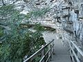
To start the Indian Ladder Trail, you go down a metal staircase. It takes you about 60 ft (18 m) down to the bottom of the cliff. From there, the trail follows the base of the cliff. You'll walk under Minelot Falls and pass a stream coming out of a small cave. This water actually comes from Thompson Lake, about two miles away! It travels through the rocky ground until it comes out here.
At the end of the trail, another set of metal stairs takes you back to the top of the cliff. The trail then continues back to the parking lot. Along the way, you'll see amazing views of the area.
-
Indian Ladder Trail, view from the path
-
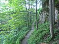
Indian Ladder Trail, the path through the wooded area
-
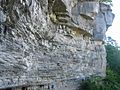
Indian Ladder Trail, base of the cliff
-
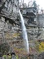
Indian Ladder Trail, Minelot Falls
-
Indian Ladder Trail, from above a staircase leading down over brush
-
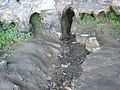
One of several underground springs at the park


The Paint Mine Trail
This trail is across the road from the Indian Ladder Trail. It's open all year, except sometimes in the spring. Snow can make hiking tough in winter. This trail is a circle, about 6 miles (10 km) long, and goes through wooded areas.
The Long Path
The Long Path is a very long hiking trail that started in the 1960s. It was first suggested by Vincent Schaefer from Schenectady. The trail begins at the George Washington Bridge in New York City. It ends right here at Thacher Park! That's a distance of about 347 miles (559 km).
Nature and Wildlife
Thacher Park is a special place for wildlife. It's a preserve, which means there are rules to protect everything here. You can't take fossils, rocks, plants, animals, or birds from the park. There are also rules about using snowmobiles in winter and causing damage. Breaking these rules can lead to trouble.
Birds of the Park


In 2004, New York State Governor George Pataki announced something exciting. About 1800 acre (7.3 km2) of Thacher Park and nearby Thompson Lake became a bird conservation area. This area helps protect birds, just like the National Audubon Society's program.
You can see about 171 different kinds of birds in the park! Many of these birds are in a special "of concern" status. This means they need extra protection. Some of these birds include:
- Sharp-shinned hawk
- Northern goshawk
- Eagle
- Golden-winged warbler
- Cooper's hawk
- Hermit thrush
- Winter wren
- Black-throated blue warbler
- Black-throated green warbler
- Louisiana and northern waterthrushes
- Canada warbler
- Worm-eating warbler
- Common raven
- Red winged blackbird
Plants and Trees
The park also has a huge variety of flowers, plants, and trees. Since it's a preserve, all these species are protected. The park has about 1400 acre (5.7 km2) of forest. Most of the trees are northern hardwoods. But you can also find:
- Eastern hemlock
- Eastern white pine
- Maple
- Basswood
- Canadian yew
- Eastern redcedar
The park has different types of natural areas. These include rocky cliffs, black oak swamps, red maple swamps, and marshy areas.
Some of the beautiful flowers you might see are:
- Flowering dogwood
- Rock elm
- Snowberry
- Hairy honeysuckle
- Purple virgin's-bower
You can also find ferns and their relatives in cool, damp spots. Look for them especially along the Indian Ladder Trail!
- Walking fern
- Purple-stemmed cliff brake
- Slender rock brake
- Maidenhair spleenwort
- Wall-rue spleenwort
The Park's Amazing Geology
The Helderberg Plateau is made of limestone rocks that are very old. They formed during the early Devonian period. This area is one of the best places in the United States to find fossils! The park is like a window into New York's past. The rocks here show us what the Earth was like hundreds of millions of years ago.
In the 1800s, famous geologists like Charles Lyell and Amos Eaton visited this spot. They came because of all the amazing fossils. James Hall (paleontologist), New York's first state paleontologist, often visited the Helderberg Escarpment. He studied and wrote about the unique fossils he found. Later, in the 1930s, Winifred Goldring continued this work. She was New York's state paleontologist and the first woman in the nation to hold that job! She even wrote a guide to Thacher State Park in 1933 that people still use today.
The cliffs here show rocks from different time periods. Below the Devonian rocks, you can see older rocks from the Upper Silurian and Upper and Middle Ordovician ages. The park's main rock is the Manlius Formation at the bottom of the cliff. Above it is the Coeymans Formation. The Manlius Formation has cool features like stromatoporoids (ancient sponge-like fossils) and cracks from when the mud dried out. The Coeymans Formation is a bluish limestone with corals and brachiopods (shellfish-like creatures).
Because the park is mostly limestone, it has a special landscape called karst. This means you'll find disappearing streams, caves, sinkholes (holes in the ground), and grikes (cracks in the rock). Thacher Park has about 40 caves! The longest one is Hailes Cave, with over 3,700 feet of mapped passages. The park also shows signs of glaciers from long ago, like scratched rocks and large boulders left behind by the ice.
