Wurtsboro, New York facts for kids
Quick facts for kids
Wurtsboro
|
|
|---|---|
|
Village
|
|
 |
|

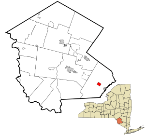
Location of Wurtsboro in Sullivan County, New York
|
|
| Country | United States |
| State | New York |
| County | Sullivan |
| Town | Mamakating |
| Area | |
| • Total | 1.25 sq mi (3.24 km2) |
| • Land | 1.25 sq mi (3.24 km2) |
| • Water | 0.00 sq mi (0.00 km2) |
| Elevation | 564 ft (172 m) |
| Population
(2020)
|
|
| • Total | 1,124 |
| • Density | 899.92/sq mi (347.41/km2) |
| Time zone | UTC-5 (Eastern (EST)) |
| • Summer (DST) | UTC-4 (EDT) |
| ZIP code |
12790
|
| Area code(s) | 845 |
| FIPS code | 36-83272 |
| GNIS feature ID | 2391227 |
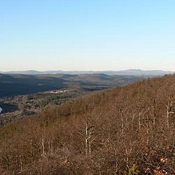
Wurtsboro is a small village in New York. It is located in Sullivan County, New York, within the town of Mamakating. The village is found along U.S. Route 209. Nearby, New York State Route 17 is being improved and will become Interstate 86. In 2020, about 1,124 people lived in Wurtsboro. The Wurtsboro-Sullivan County Airport has served the area since 1927.
Contents
History of Wurtsboro
Early Native American Life
Before Europeans arrived, the Leni Lenape Native Americans lived in the Wurtsboro area. Europeans called them the Delaware. Other tribes called them "the old people" because they were one of North America's oldest tribes. Many experts believe the Leni Lenape were among the first people to come to North America. They had many villages between the Delaware and Hudson rivers. The group living in the Wurtsboro area was known as the Mamacottin.
Dutch Settlers and Old Mine Road
As Dutch settlers moved along the Hudson River, they looked for furs and minerals. They built what is thought to be America's oldest road. This road was a simple path that followed old Leni Lenape trails. It became known as the Old Mine Road. Today, U.S. Route 209 follows much of this original path. The Dutch settlers likely gave the area its first name, Mamakating.
From Rome to Wurtsboro
The village of Wurtsboro was first called Rome. People say that when settlers arrived, they saw many mountain peaks. They ambitiously named the place Rome. This name was used until at least 1812. That year, the first church, called the "Church of Rome," was built. Later, the town was renamed Wurtsborough, which eventually became Wurtsboro.
The Delaware and Hudson Canal
During the early industrial revolution, America needed coal. England supplied most of it. But during the War of 1812, a British blockade stopped coal shipments. People then looked to anthracite coal from Pennsylvania. However, it was hard to transport.
Three brothers named Wurts saw this problem. Maurice Wurts was the most famous. They owned a store in Philadelphia. They started a company to build a 108-mile canal. This canal, called the Delaware and Hudson Canal, went from Honesdale, Pennsylvania, to Kingston, New York. On July 13, 1825, Philip Hone, the mayor of New York City and an investor, started the canal's construction in Wurtsboro.
The canal helped ship goods like coal, lumber, and livestock. These items traveled through Wurtsboro on their way to Albany and New York City. The D&H Canal Company often renamed towns along the canal after their favorite officers. This is how towns like Honesdale, Port Jervis, Hawley, and Wurtsboro got their names.
Railroads and Tourism
Over time, steam power and railroads replaced canals. The canal operated until 1898. The D&H Railroad was actually a new version of the original canal company. In many places, the old railroad tracks run next to the canal. You can see both by visiting the D&H Canal Linear Park. This park is a walking path along the canal from Wurtsboro to Summitville.
The original village of Wurtsboro was built right next to the canal. Some old businesses still exist today. For example, Danny's, built in 1814, served food and offered lodging. The Canal Towne Emporium was once Fulton & Holmes’ General Store. It sold many items delivered by canal boats. Over time, the village grew westward and joined with the old village of Mamakating. In 1830, the post office name changed from Mamakating to Wurtsborough.
Another important industry was tanning. Hemlock bark was used to tan animal hides. This bark was very common in the area. In fact, over 80% of all leather goods for the Union Army during the American Civil War were processed in Sullivan County. The tanning industry declined when hemlock trees became scarce and new tanning chemicals were invented.
In the late 1800s, the Ontario & Western Railroad built tracks on the east side of the village. Like the canal, it carried goods and passengers. The O&W Railroad played a big role in the tourism boom of the late 1800s and early 1900s. It allowed thousands of New York City residents to escape the city heat and enjoy the fresh air of the Catskill Mountains. Eventually, just as railroads replaced canals, the interstate highway system replaced railroads.
Geography
Wurtsboro covers about 1.3 square miles (3.24 square kilometers) of land. There is no water area within the village limits. The Long Path, a popular hiking trail, passes through Wurtsboro.
Two important historical places in Wurtsboro are listed on the National Register of Historic Places. These are the Mamakating Park Historic District and the Masten-Quinn House.
Population Information
The population of Wurtsboro has changed over the years. Here is a look at how many people have lived in the village:
| Historical population | |||
|---|---|---|---|
| Census | Pop. | %± | |
| 1870 | 797 | — | |
| 1880 | 538 | −32.5% | |
| 1890 | 490 | −8.9% | |
| 1900 | 450 | −8.2% | |
| 1910 | 478 | 6.2% | |
| 1920 | 362 | −24.3% | |
| 1930 | 423 | 16.9% | |
| 1940 | 487 | 15.1% | |
| 1950 | 628 | 29.0% | |
| 1960 | 655 | 4.3% | |
| 1970 | 732 | 11.8% | |
| 1980 | 1,128 | 54.1% | |
| 1990 | 1,048 | −7.1% | |
| 2000 | 1,234 | 17.7% | |
| 2010 | 1,246 | 1.0% | |
| 2020 | 1,124 | −9.8% | |
| U.S. Decennial Census | |||
In 2000, there were 1,234 people living in Wurtsboro. There were 479 households and 330 families. The population density was about 975 people per square mile. Most residents (93.68%) were white. About 1.86% were African American, and 0.81% were Asian. About 4.62% of the population was Hispanic.
About 39.5% of households had children under 18. About 50.3% were married couples. The average household had 2.58 people, and the average family had 3.15 people.
The median age in the village was 35 years old. About 30.2% of the population was under 18. About 10.3% were 65 or older. The median income for a household was $38,500. For families, it was $46,359. About 10.9% of the population lived below the poverty line.
Images for kids
See also
 In Spanish: Wurtsboro para niños
 | George Robert Carruthers |
 | Patricia Bath |
 | Jan Ernst Matzeliger |
 | Alexander Miles |


