Mamakating, New York facts for kids
Quick facts for kids
Mamakating, New York
|
|
|---|---|

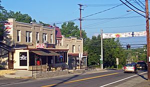
Downtown Bloomingburg
|
|

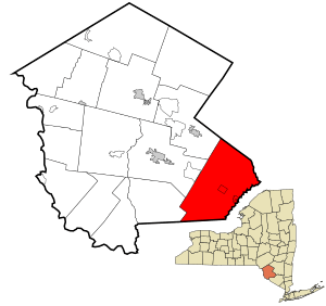
Location of Mamakating in Sullivan County, New York
|
|
| Country | United States |
| State | New York |
| County | Sullivan |
| Area | |
| • Total | 98.67 sq mi (255.55 km2) |
| • Land | 96.11 sq mi (248.92 km2) |
| • Water | 2.56 sq mi (6.63 km2) |
| Elevation | 840 ft (256 m) |
| Population
(2020)
|
|
| • Total | 12,655 |
| • Density | 128.256/sq mi (49.5206/km2) |
| Time zone | UTC-5 (Eastern (EST)) |
| • Summer (DST) | UTC-4 (EDT) |
| FIPS code | 36-44809 |
| GNIS feature ID | 0979187 |
Mamakating is a town located in the southeastern part of Sullivan County, New York, in the United States. In 2020, about 12,655 people lived here.
Contents
History of Mamakating
Early Land and Settlement
In 1706, a person named Johanis Hardenburgh bought a very large area of land. This land, along with another area called the Minisink Patent, makes up most of what is now Orange and Sullivan Counties.
The town of Mamakating was officially started on December 17, 1743. It was first known as the Precinct of Mamakating in Ulster County. This area was as big as what later became Sullivan County. Some people used to call it Mamacotten. Over many years, this large area was divided into smaller towns. Mamakating is thought to be the very first town in Sullivan County. Its first main office, called the county seat, was set up in the village of Bloomingburg in 1809.
Forts and Protection
In the early and mid-1700s, several forts were built along the Old Mine Road. These forts helped protect the European settlers as they expanded their land. Three forts were built in Mamakating.
- Fort Westbrookville was built in 1750 near the border of Sullivan and Orange counties.
- Fort Devans was built in 1757 north of the village of Wurtsboro.
- Fort Roosa was built in 1731 on the east side of Bloomingburgh Mountain. It is still standing today and is considered the oldest building in Sullivan County.
Many people traveling the Old Mine Road from Kingston found this area appealing. It had good land for farming, lots of animals to hunt, streams full of fish, and trees for building homes. They decided it was a good place to settle down and raise families.
Changes After the Revolution
After the American Revolution ended, Mamakating became smaller. Parts of it were used to form other towns like Deerpark (in Orange County) and Lumberland in 1798. Mamakating got its current size when Thompson was formed in 1803, and a part was given to Forestburgh in 1837.
Education and Transportation
The first school in Sullivan County was built in Bloomingburg in 1788. In 1825, two brothers named Wurts decided to build the Delaware and Hudson Canal. This canal was used to transport coal from Pennsylvania to people in New York City. The first boats carrying coal arrived at the Hudson River in November 1828. On their way back, the boats brought many goods that the people of Sullivan County needed. This way, the canal made money on both parts of its journey. The D&H Canal helped Mamakating and all of Sullivan County become more successful.
In 1899, the railroad arrived, which slowly led to the end of the D&H Canal. In recent years, people in Sullivan County have been working to save what is left of the D&H Canal. You can still see parts of it today, like a section between Summitville and Phillipsport, which has been cleaned up. Signs explain the different parts of the canal.
Historic Places and Industries
Mamakating has many historic places. One important spot is the grave of Manual Gonsalus, who was one of the first European settlers. His tombstone is dated April 18, 1752. Other historic places include:
- The Phillipsport United Methodist Church, built in 1823.
- The Bloomingburg Reformed Church, built in 1820, which is now a county historic landmark.
- The Stanton Cemetery, located north of Wurtsboro, where many of the oldest settlers are buried. This is a popular place for people researching their family history.
Up on the east mountain, above the Wurtsboro airport, you can still see the remains of an old lead mine. Some of the lead from this mine was used to make bullets for the Union Army during the American Civil War.
In the early 1800s, Sullivan County had many tanneries, which are places where animal hides are turned into leather. Several of these tanneries were in Mamakating. The leather made here was very good quality. During the Civil War, it was used to make boots, saddles, and other leather goods for the Union Army. In 1850, Mamakating's five tanneries produced 29,000 leather hides.
Mamakating Historical Society
The Mamakating town board asked the town co-historian, John Masten, to start a historical society. They took over an old school building in Summitville and completely fixed it up. Masten accepted, and today the building has a room for old records, a meeting room with many pictures and stories about Mamakating, and many old items from the area. The Historical Society has about 165 members.
A funny local nickname for people who live in Mamakating is "Mamacoots." This name combines the old name "Mamacotten" with the ending "kuts."
Geography of Mamakating
The eastern border of Mamakating is the line for Orange County. The northern border is the line for Ulster County. US 209 runs through the town from north to south. NY 17 (which will become Interstate 86) crosses the town from east to west.
The town covers a total area of 98.2 square miles (254 km2). Most of this, 95.9 square miles (248 km2), is land, and 2.3 square miles (6.0 km2) (about 2.37%) is water.
The highest point in Mamakating is 1,648 feet (502 m) high. This spot is near the meeting point of Mamakating Avenue and Park Road in the Mamakating Park Historic District. The lowest point is 340 feet (100 m) high. This is where the Bush Kill stream flows into the Shawangunkill, at the border with Orange and Ulster counties.
Population Information
| Historical population | |||
|---|---|---|---|
| Census | Pop. | %± | |
| 1790 | 1,763 | — | |
| 1820 | 2,762 | — | |
| 1830 | 3,062 | 10.9% | |
| 1840 | 3,418 | 11.6% | |
| 1850 | 4,107 | 20.2% | |
| 1860 | 3,828 | −6.8% | |
| 1870 | 4,866 | 27.1% | |
| 1880 | 3,845 | −21.0% | |
| 1890 | 3,401 | −11.5% | |
| 1900 | 3,128 | −8.0% | |
| 1910 | 2,922 | −6.6% | |
| 1920 | 2,395 | −18.0% | |
| 1930 | 2,277 | −4.9% | |
| 1940 | 2,407 | 5.7% | |
| 1950 | 2,632 | 9.3% | |
| 1960 | 3,356 | 27.5% | |
| 1970 | 4,319 | 28.7% | |
| 1980 | 7,717 | 78.7% | |
| 1990 | 9,792 | 26.9% | |
| 2000 | 11,004 | 12.4% | |
| 2010 | 12,085 | 9.8% | |
| 2020 | 12,655 | 4.7% | |
| U.S. Decennial Census | |||
In the year 2000, there were about 11,002 people living in Mamakating. These people lived in 4,153 households, and 2,936 of these were families. The population density was about 114.7 inhabitants per square mile (44.3/km2), meaning there were about 114.7 people for every square mile.
About 35.5% of households had children under 18 living with them. About 56.6% were married couples living together. The average household had 2.64 people, and the average family had 3.14 people.
The population was spread out by age:
- 26.9% were under 18 years old.
- 6.9% were between 18 and 24.
- 30.4% were between 25 and 44.
- 24.8% were between 45 and 64.
- 10.9% were 65 years or older.
The average age in the town was 37 years.
The median income for a household in the town was about $41,726. The median income for a family was $49,615. The average income per person was $19,451. About 10.3% of the total population lived below the poverty line, including 10.0% of those under 18 and 9.2% of those 65 or older.
Communities and Locations in Mamakating
Here are some of the communities and important places you can find in Mamakating:
- Bashakill – A large marsh area in the southern part of the town.
- Bloomingburg – A village within the town.
- Burlingham – A small community near the eastern town line. The Hart House here is a historic building.
- Culvertown – A small community near the western town line.
- Haven – A small community near the southeastern town line.
- High View – A location near Bloomingburg.
- Mamakating Park – A community northeast of Wurtsboro village. It was built in the 1890s as a resort and is now a historic district.
- Mount Prosper – A small community west of Wurtsboro village.
- Phillipsport – A small community north of Wurtsboro on Route 209.
- Roosa Gap – A location west of Burlingham.
- Spring Glen – Part of this community, which is mostly in Ulster County, is also in Mamakating along Route 209.
- Summitville – A small community north of Wurtsboro on Route 209.
- Winterton – A small community in the southeastern part of the town.
- Wurtsboro – A village within the town.
- Wurtsboro Hills – A small community northwest of Wurtsboro village.
- Wurtsboro-Sullivan County Airport (N82) – An airport located north of Wurtsboro village.
- Yankee Lake – A small community west of Wurtsboro village, next to a lake of the same name.
See also
 In Spanish: Mamakating para niños
 | Selma Burke |
 | Pauline Powell Burns |
 | Frederick J. Brown |
 | Robert Blackburn |

