Kaaterskill High Peak facts for kids
Quick facts for kids Kaaterskill High Peak |
|
|---|---|
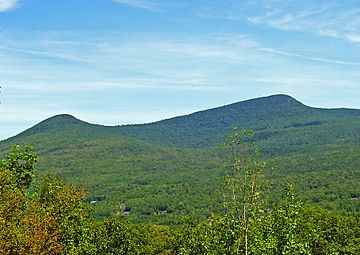
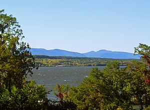
Kaaterskill High Peak from southwest
|
|
| Highest point | |
| Elevation | 3,655 ft (1,114 m) NAVD 88 |
| Prominence | 1,775 ft (541 m) |
| Listing | Catskill High Peaks 22nd |
| Geography | |
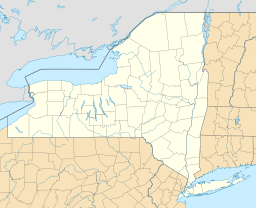
| Location | Catskills, New York, U.S. |
| Parent range | Escarpment |
| Topo map | USGS Kaaterskill |
| Climbing | |
| First ascent | Peter delaBigarre and companion; July 26, 1793 (recorded) |
| Easiest route | trail, path |
Kaaterskill High Peak (also known as High Peak) is a famous mountain in the Catskill Mountains of New York, United States. It is located in the Town of Hunter in Greene County. Long ago, people thought it was the tallest mountain in the entire Catskill range.
However, its top is actually 3,655 feet (1,114 m) high. This makes it the 23rd tallest among the Catskill High Peaks. Even so, it is the fourth most important peak in the range when you consider how much it stands out from the land around it. Because it is the easternmost High Peak, its top is just outside the areas that collect water for New York City's reservoirs.
High Peak and nearby Round Top create a unique shape that helps identify the Catskills. You can easily see it from the Hudson Valley. In the early 1800s, artists like Thomas Cole often painted this mountain. Their paintings helped make the Catskill Mountain House a popular summer spot for rich Americans.
Even though it was popular to admire, not many people climbed the mountain. It has the earliest recorded climb of any Catskill peak. Today, it does not have an official path to its top. But there is a well-used path that hikers enjoy. They love the amazing views from Hurricane Ledge and other spots nearby.
Contents
Mountain Names: High Peak and Round Top
Originally, High Peak and Round Top had their names switched. This was because of how their tops looked different. But people got confused about which one was truly "High Peak." The higher mountain officially became High Peak in the late 1800s. The lower one became Round Top. The "Kaaterskill" part of the name comes from a nearby creek and valley. This helps tell it apart from other "High Peaks" in the area.
In the late 1700s, the mountain was called Liberty Cap. It looked like the Phrygian cap, a hat that was popular during the American and French revolutions.
Where is Kaaterskill High Peak?
High Peak stands a bit separate from other big mountains in the Catskills. It is right in the middle of the Catskill Escarpment. This is where the mountains suddenly rise from the Hudson Valley floor. From the valley, it is easy to see why people thought it was the tallest peak. There are no taller mountains close to it. It is also located between two gaps in the Escarpment: Platte Clove to the south and Kaaterskill Clove to the north.
High Peak is a bit unusual as a mountain. Its sides spread out and rise gently at first. Then they get a bit steeper, leading to the rounded top. This top is surrounded by rock cliffs about 3,500 feet (1,100 m) high. Above these cliffs, the ground gently curves up to the very top.
Water from the north flows into Kaaterskill Creek. Water from the south flows into Plattekill Creek. Both of these creeks reach the Hudson River quickly.
Even though High Peak is not the tallest, it ranks fourth in how much it stands out. This is after Slide Mountain, Hunter Mountain, and Black Dome. High Peak's top rises 1,775 feet (541 m) from the lowest line of elevation that goes all the way around it.
Round Top Mountain
The mountain once called High Peak is now Round Top. It is about 3,440-foot (1,050 m) tall. It is located about one mile (1.6 km) west of High Peak's top. Even though it is considered a separate peak, it is often seen as High Peak's lower partner.
History of Kaaterskill High Peak
The first recorded climb of Kaaterskill High Peak happened on July 26, 1793. A French visitor named Peter DeLaBigarre climbed it with a friend. His friend used a barometer to measure the mountain's height. They thought it was the tallest Catskill peak and renamed it Liberty Cap. They measured its height at 3,549 feet (1,082 m) above sea level. This is very close to its actual height today. This was the earliest recorded climb of any Catskill High Peak.
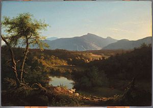
This visit helped set the stage for the early 1800s. A young artist named Thomas Cole visited the Catskill Mountain House. He painted many scenes of the Catskill wilderness. These paintings were part of the famous Hudson River School art movement. High Peak often appeared in the background of his works. His art made the Mountain House even more popular.
One visitor was Arnold Henry Guyot, a geography professor from Princeton. In the 1870s, he explored other mountains in the region. He soon realized that High Peak was not the tallest mountain. He used his surveying tools to create the first accurate map of the Catskill Mountains. He found that Slide Mountain was the tallest at 4,180 feet (1,270 m). This made High Peak the 23rd tallest. He also helped switch the names of High Peak and Round Top.
The hotel owners did not like his findings, but his measurements were correct. In 1879, other surveyors confirmed his work. When New York created its Forest Preserve, they celebrated by climbing Slide Mountain, not High Peak. An observation tower was built on High Peak in the late 1800s. It was removed when the state bought the land.
Interest in the mountain decreased after that. Even today, there is no officially maintained path to its top. However, the "unofficial" Twilight Trail is still well-used. In 1921, both High Peak and Round Top became part of the Forest Preserve.
The southern side of the mountain has seen some building over the years. A former police camp was once considered for a prison. But the plan was dropped after local people protested. Today, it is home to one of the Bruderhof Communities. There are still some private lands in the area.
A small railroad was once built on the south slopes. It was used to carry logs out of the area. You can still find parts of its steel-topped wooden rails. On the north slope, there is a community called Twilight Park.
Two small airplanes crashed on the mountain in the late 1900s. One crash happened on June 13, 1967. The remains can still be found east of the top. Another crash happened on June 25, 1987. Its remains can be found along the snowmobile trail loop.
A small ski area called Cortina Valley opened in 1975. It was on the northwestern slope of Round Top. But it closed for good around 2000. Its three trails still remain.
The state built a snowmobile loop around both peaks. It starts at the top of Platte Clove. But it is not used much, even in snowy winters. More of the mountain has been added to the Forest Preserve over time. The New York State Department of Environmental Conservation manages it. It is part of the Kaaterskill Wild Forest in Catskill Park.
Nature on Kaaterskill High Peak
Like most of the Catskills, High Peak is covered with a northern-hardwood forest. This forest has many beech, birch, and maple trees. The tops of both High Peak and Round Top have a boreal forest. This forest is made up of balsam fir and red spruce trees. Even though the mountain has been developed, much of the forest above 3,000 feet (910 m) is first-growth. This means it has never been cut down.
Spruce, fir, and pine trees also grow in an area called Pine Plains. This area is east of the top, below 3,000 feet (910 m). The ground here stays wet and muddy. This allows these trees to grow well. In late spring, you can see many wildflowers here. These include trillium and clintonia.
How to Hike Kaaterskill High Peak
Most hikers use two main ways to reach the mountain. Both use parts of the Long Path hiking trail. The southern route is very popular. It has a gentle, almost flat climb for most of the way. This lets hikers keep a good pace for the final climb to the top. The northern route passes beautiful waterfalls and overlooks. It requires climbing almost 3,000 feet (910 m). This is the most climbing possible on any route up a major Catskill peak.
A shorter third route from the south is possible. But you need permission to cross private land first. All routes depend on the snowmobile trail. The unofficial Twilight Park Trail is used to reach the top.
Southern Hiking Route
Hikers start from the parking lot at the top of Platte Clove. They follow the old Steenburg Road, which is now the snowmobile trail. It is marked with orange discs for snowmobiles and blue discs for hikers. The blue discs mark sections of the Long Path. You can see waterfalls from a nearby stream, but they are on private land.
The path goes uphill gently but steadily. About one mile (1.6 km) from the start, there is a sign. It shows distances to Palenville and other spots. From here, the trail gets narrower. It starts to curve northeast into state land. A yellow-marked path, the former Nature Friends Trail, leads to the scenic Huckleberry Point overlook.
The trail becomes flatter and heads north. It crosses some small streams. You can still see markers for private land boundaries. Then, the path starts to climb gently again. This leads into a forest with more beech trees. This is the start of Pine Plains, 1.25 miles (2.01 km) from the Huckleberry Point path. The trail also starts to curve west.
Spruce, fir, and other evergreen trees become common here. The trail is often wet. But many hikers enjoy the scenery, especially the wildflowers in late spring.
After Pine Plains, the forest changes back to more leafy trees. The trail stays flat and heads west. It crosses many small streams. Finally, at a junction 3.7 miles (6.0 km) from the start, the Long Path goes down into Kaaterskill Clove. The snowmobile route goes up a slightly steeper slope. After a short distance, it reaches the loop.
From here, hikers have two choices. They can turn right (west) and look for two piles of rocks (called cairns). These mark the north end of the Twilight Park Trail. Or, they can turn left and go around the mountain. They will pass one of the plane wrecks. As the path curves right, they will find a 5-foot-high (1.5 m) cairn. This marks the south end of the Twilight Park Trail.
This trail is wet and sometimes hard to see. But it is marked with small cairns, tape, and old blue paint. It is not very steep, but it climbs almost constantly. It is responsible for the last 450 vertical feet up the mountain in less than a mile. The southern approach is probably best for climbing the steepest parts.
The trail starts by winding through scrubby woods. Then it goes past impressive rock outcrops. Here, it is more worn and easier to follow. Finally, just above 3,500 feet (1,100 m), it reaches a short, steep rock face. You need to do some scrambling to get up it. From here, you get a view north of the Blackhead Range, over Kaaterskill Clove. You can clearly see Kaaterskill Falls below.
Beyond this, the path becomes even clearer. The forest changes completely to spruce and fir trees. The path goes up gently, then levels out, then climbs again. This leads to the small, treeless top. The total distance is about 5 miles (8.0 km) from the trailhead. The climb is 1,455 feet (443 m).
Some hikers prefer to continue south on the Twilight Park Trail on the way back. Or they stay on the loop to the plane wreck. From there, they can hike off-trail to save time.
Northern Hiking Route
The northern route starts at the parking area in Palenville. A dirt road marked with blue-green blazes (for the Long Path) begins here. It climbs steadily and sometimes steeply for two miles (3.2 km) up the side of Kaaterskill Clove. The trail turns sharply at the top of a small hill. Then it goes down slightly to two streams.
After climbing half a mile (1 km), the trail reaches Wildcat Falls. A ledge here offers a great view into Kaaterskill Clove. Another half-mile brings you to Buttermilk Falls. This is a two-step waterfall just off the trail. Just 0.2 miles (320 m) later, the old road ends. The trail then climbs seriously over steep slopes and narrow ledges. This continues for 0.65 miles (1.05 km) before joining the Twilight Park Trail. The junction with the snowmobile trail is another 0.2-mile (0.32 km) uphill.
This route is about 7 miles (11 km) to the top. It involves climbing 2,990 vertical feet (911 m).
Other Ways to Reach the Top
Sometimes, hikers reach the top from Round Top. They stay along the ridgeline when climbing both peaks. Some brave hikers go straight up from the lower plane crash site to the upper one. This involves climbing over cliffs. It is also possible to approach from the northwest. This is via an unmarked trail through Cortina Valley. The main challenge here is finding your way on the ledges.
Kaaterskill High Peak Summit
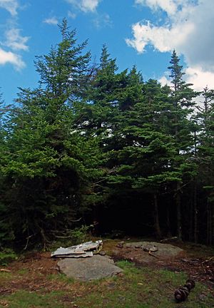
The very top of Kaaterskill High Peak is a small, grassy clearing. It does not have views because it is surrounded by boreal forest. A rock in the center has a marker. This marker points to two nearby United States Geological Survey benchmarks. These mark the highest point on the mountain at 3,655-foot (1,114 m) elevation. The actual bolts are on rocks in the nearby woods.
Interesting Spots on High Peak
Besides the summit, several other attractions on and around High Peak draw hikers.
Hurricane Ledge
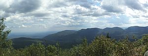
Since the summit has no views, most hikers go to Hurricane Ledge. This is a wide, open area above a cliff on the south side of the mountain. It is about 0.1 miles (160 m) from the top. From here, you can see Indian Head and Twin mountains. These are part of the Devil's Path. You can also see Plateau to the west. To the east, the Catskills drop sharply into the valley. A long part of the Hudson River is also visible.
The area is named either for a big storm in 1950 that supposedly cleared the trees. Or it is named for the strong winds felt there because there are no trees. It is the only area in the Catskills that feels like it is above the tree line.
Huckleberry Point
The trail that splits from the snowmobile route leads to Huckleberry Point. This is a steep, rocky area. Thanks to past fires, it has many spots to sit and look down into the valley. The route is mostly flat and shorter than climbing the whole mountain. So, it is popular with casual hikers. But be careful at the Point, as some ledges are above sharp drops.
Round Top Mountain
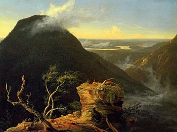
Because it was easier to reach, artists like Thomas Cole preferred to climb Round Top. They would sketch the views from there. Some of these sketches became famous paintings, like Sunny Morning on the Hudson River. Today, Round Top is less popular than High Peak. But it is still one of the fifty tallest peaks in the Catskills. Some dedicated hikers still visit it. Its top can be reached by paths from the snowmobile trail near Cortina Valley.
Brant Fort
An old fort can be found south of the low point between High Peak and Round Top. It is at 2,540 feet (770 m) high. British troops first built it during the French and Indian War. Later, during the Revolutionary War, it was used by Tories (people loyal to Britain) and their Indian allies. From this spot, they could watch troop movements in the valley.
Prisoners captured in the region were often brought here first. Then they were taken to what is now Canada. Joseph Brant, a famous Indian warrior who fought for the British, visited once. This led to legends that he based his raids here. The fort has been informally named after him ever since, even though he was not very involved with it.
Plane Crash Sites
The many airplane accidents in the Catskills have become a point of interest for hikers. The lower of the two crash sites on High Peak is easy to reach. It is right on the snowmobile loop. Much of the fuselage (the main body of the plane) is still there. The state does not prioritize removing the wreckage. It was briefly a geocache site, but this was removed because it is not allowed in the Forest Preserve.
The upper crash site is harder to find. It is on the cliffs east of the summit. Faint paths can lead to it. A small piece of this wreckage was once placed on the rock at the summit.
 | Kyle Baker |
 | Joseph Yoakum |
 | Laura Wheeler Waring |
 | Henry Ossawa Tanner |


