Rusk Mountain facts for kids
Quick facts for kids Rusk Mountain |
|
|---|---|

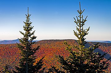
Rusk in autumn from near the summit
of neighboring West Kill Mountain |
|
| Highest point | |
| Elevation | 3,680 feet (1,125 m) |
| Prominence | 760 feet (230 m) |
| Listing | Catskill High Peaks 21st |
| Geography | |
| Location | Jewett / Lexington, New York, U.S. |
| Parent range | Catskills |
| Topo map | USGS Lexington |
| Climbing | |
| Easiest route | ridge south of Ox Hollow |
Rusk Mountain is a cool peak located in the towns of Jewett and Lexington in Greene County, New York, United States. It stands tall at 3,680 feet (1,121 m). This makes it one of the highest mountains in the Catskill Mountains. It is also known as one of the Catskill High Peaks.
Even though there isn't a marked trail to the top, many hikers enjoy finding their own way up. This kind of hike is called a "bushwhack." Climbing Rusk Mountain is a fun challenge. It's also required if you want to join the special Catskill Mountain 3500 Club.
Contents
Exploring Rusk Mountain's Geography
Rusk Mountain is the tallest peak on what is called the Lexington Range. This range branches off from Hunter Mountain. Hunter Mountain is the second-highest peak in the Catskills.
There's another smaller peak near Rusk Mountain. It's about 3,640 feet (1,109 m) tall. People sometimes call it East Rusk. The Lexington Range continues west to other mountains like Evergreen and Packsaddle. It finally ends near the town of Lexington.
Water Flow and Views
Rusk Mountain is part of the Schoharie Creek area. This means that rain and snow that fall on the mountain flow into this creek. Water from the southern parts of Rusk Mountain goes into Hunter Brook. This brook then joins the West Kill river. The northern parts of the mountain drain directly into the Schoharie Creek.
All this water helps fill the Schoharie Reservoir. This reservoir is an important part of the New York City water supply. So, the water from Rusk Mountain helps people in New York City drink clean water!
From the Spruceton Valley, West Kill Mountain looks taller than Rusk. But Rusk Mountain actually rises more dramatically from the valley floor. You can see the entire north side of Rusk Mountain from NY 296. This is just north of its meeting point with NY 23A.
The northern slope of Rusk Mountain goes up steeply to the top. The southern side has a valley called Ox Hollow. The ridge south of Ox Hollow is the most popular way to climb the mountain.
Protecting the Land
Most of Rusk Mountain is owned by New York State. It's part of the Forest Preserve. This area is currently part of the Hunter Mountain Wild Forest. There's a plan to make the land on Rusk Mountain a new "wilderness area." This would help protect it even more.
The History Behind Rusk Mountain
Rusk Mountain was named by Arnold Henri Guyot. He was a geology professor from Princeton University. In the 1870s and 1880s, he made the first accurate map of the Catskills. Samuel Rusk helped him a lot with this important work. That's why the mountain was named after Samuel Rusk.
Professor Guyot probably climbed Rusk Mountain first during his mapping trips. But we don't know for sure if anyone else had climbed it before him.
Nature on Rusk Mountain
Rusk Mountain is home to some amazing natural features. In the upper parts of Ox Hollow, there are very old Eastern hemlock trees. These trees are special because they are "virgin stands." This means they have never been cut down by people.
This suggests that loggers in the late 1800s didn't reach this area. These loggers cut down many trees to get "tannin" from the bark. Tannin was used to make leather. Even though some areas were logged, old "skid roads" can still be found. These were paths used to drag logs down the mountain.
Below 3,000 feet (900 m), the forest is mostly beech and maple trees. These are common "second-growth" trees. This means they grew back after the original forest was cut down.
As you climb higher, the trees become smaller. Near the top, you'll find red spruce and balsam fir trees. These trees are typical of a "boreal forest." This type of forest is found in cold, northern areas. Rusk Mountain's summit forest is more open than some other Catskill peaks. This makes it easier to walk through.
How to Hike Rusk Mountain
There are a few ways to hike up Rusk Mountain. The most popular way is from the south. This is because of how the land is owned and where roads are.
The Ox Hollow Route
Hikers often start this route from Spruceton Road. This road is about six miles (9.6 km) east of NY 42 in West Kill. You follow the Spruceton Trail for about 0.5 miles (900 m). Then, you'll see an old road going southwest.
You follow this old road. It's an easy walk across a small stream. Soon, you'll be on the main ridge. From here, it's pretty easy to follow the wide ridge straight up. You might see an old stone wall from when people tried to farm this land.
The forest here is usually open. But in wet summers, you might find stinging nettles. Above 3,200 feet (975 m), the climb gets harder. The slope becomes steeper and rockier. There are also many small trees that you'll need to push through.
When you reach about 3,500 feet (1,067 m), you'll be at the bottom of some shale cliffs. These cliffs are the trickiest part of this route. They aren't super steep, but it can take some time to find a safe way up. You might need to use your hands to climb.
Once you are past the cliffs, the ground becomes flat. If you turn north, you'll find a "herd path." This is a small, unofficial trail. It leads to the summit and a special container where hikers can sign in.
Near the top of this short climb, you get a great view! You can see east and southeast towards Kaaterskill High Peak, Hunter, and Southwest Hunter. There's also a view across the valley to West Kill's summit.
This route climbs about 1,597 feet (487 m). The total distance to the top from Spruceton Road is about 2 miles (3.2 km).
Ox Hollow Creek Option
Some hikers prefer to follow the creek at the bottom of Ox Hollow. They climb the steep "headwall" of the hollow to the summit. This way avoids the cliffs but can be more difficult later on.
Other Ways to Climb
- East from Taylor Hollow: If you're climbing Hunter and Rusk mountains on the same trip, you can follow the ridge from the Spruceton Trail at Taylor Hollow. This is a gentler climb.
- Southwest: There are some private roads that go up the mountain from the southwest. If you get permission from the landowners, this could be an easier way to hike.
- North Face: This side of the mountain is on public land. But you still need permission to cross private land to reach its base. This route is very steep, climbing 2,180 feet (664 m). There isn't a clear path here.
Reaching the Summit
Like many Catskill peaks, the very top of Rusk Mountain is quite flat. This can make it hard to find the exact highest point. The herd path from the promontory is usually easy to follow. It leads to the summit "canister." This is a metal box where hikers can sign their names. There's plenty of space at the top for hikers to relax and have lunch.
The best views are usually found early on the herd path. You can see Kaaterskill High Peak and Hunter Mountain. If there are no leaves on the trees, you might find some limited views of West Kill Mountain.
Some hikers have used GPS devices at the summit. Their readings suggest that Rusk Mountain might actually be a little taller than what is officially reported!
 | Leon Lynch |
 | Milton P. Webster |
 | Ferdinand Smith |


