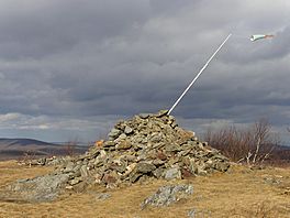
South Taconic Trail facts for kids
Quick facts for kids South Taconic Trail |
|
|---|---|

Summit of Brace Mountain,
highest point on the trail |
|
| Length | 21.3 mi (34.3 km) |
| Location | Dutchess County / Columbia County, New York; Berkshire County, Massachusetts |
| Use | hiking, backpacking, snowshoeing |
| Highest point | Brace Mountain, 2,311 ft (704 m) |
| Lowest point | Bash Bish Brook, 732 ft (223 m) |
| Difficulty | Moderately difficult |
| Season | easiest mid-May through early October |
| Hazards | deer ticks, poison ivy, weather |
The South Taconic Trail is a fun hiking path. It stretches about 21.3 miles (34.3 km) long. You can find it in the Taconic Mountains. This area is in southwest Massachusetts and nearby New York.
The trail starts near Shagroy Road in Millerton, New York. It goes north along the top of the southern Taconic Range. This path follows the border between New York and Massachusetts. It finishes north of the Catamount Ski Area. This spot is on Massachusetts Route 23 in Egremont, Massachusetts. The famous Appalachian Trail is also in the same mountains. It runs about 3 miles (4.8 km) east of the South Taconic Trail. Shorter paths connect these two trails.
Contents
About the Trail
The South Taconic Trail goes through several towns. In New York, it passes through Millerton and Copake. In Massachusetts, it goes through Mount Washington and Egremont. This trail also crosses through some cool parks. These include Taconic State Park, Mount Washington State Forest, and Bash Bish Falls State Park.
What You'll See
The trail is marked with white blazes. These are painted marks that show you the way. The path follows high, open mountain tops and ridges. From here, you can see amazing views of the Hudson River Valley to the west. It's a great place to take photos!
Camping on the Trail
If you want to stay overnight, you can! Camping is allowed in special spots. There are designated areas on Alander Mountain. You can also camp at the Copake Falls Campground in Taconic State Park. Remember to always follow park rules when camping.
Who Takes Care of the Trail
Many groups help keep the trail in good shape. These include the Berkshire Chapter of the Appalachian Mountain Club. The mid-Hudson chapter of the Adirondack Mountain Club also helps. Other groups are the New York - New Jersey Trail Conference and the Sierra Club. They work hard so everyone can enjoy the trail.
Nature on the Trail
The forests along the South Taconic Trail are a mix of trees. You'll see oak and hickory trees. There are also northern hardwood trees. Some parts of the mountain tops are open and grassy. These are called balds. You might also find special plants that like alkaline soil.
Mountains and Waterfalls
Along the trail, you'll find several interesting spots. These include the tops of mountains like Brace Mountain and Alander Mountain. You can also visit Sunset Rocks and Mount Fray. One of the most famous sights is Bash Bish Falls. This is a beautiful waterfall in Massachusetts.
Trail Extension
In 2015, the South Taconic Trail got longer. A new six-mile section was finished. This part connects Brace Mountain to Rudd Pond State Park to the south. This means even more trail to explore!
 | Shirley Ann Jackson |
 | Garett Morgan |
 | J. Ernest Wilkins Jr. |
 | Elijah McCoy |

