Minisink facts for kids
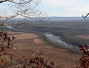
The Minisink is a historic area in the Upper Delaware River valley. It covers parts of northwestern New Jersey (Sussex and Warren counties), northeastern Pennsylvania (Pike and Monroe counties), and New York (Orange and Sullivan counties).
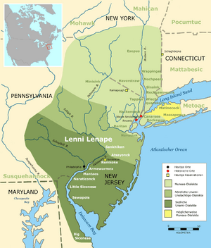
The name "Minisink" comes from the Munsee people, a group of Lenape Native Americans who lived here long ago. The first European settlers arrived in the late 1600s and early 1700s. They were mostly Dutch and French Huguenot families from New York's Hudson Valley. Today, the name "Minisink" is not used much, but it reminds us of the early history of the region and the first meetings between Native Americans and European explorers.
A large part of the historic Minisink region is now part of the Delaware Water Gap National Recreation Area. This happened after a plan to build a large dam on the Delaware River was stopped.
Contents
What "Minisink" Means
The name Minisink comes from the Munsee dialect of Lenape. This was a language spoken by the Lenape people who lived in the area before Europeans arrived. Minisink means "at the island" in their language. It comes from the word minis, which means island.
During the colonial period, the Minisink area saw many fights between British and French-allied forces during the French and Indian War (also known as the Seven Years' War). To protect against attacks, Benjamin Franklin ordered forts to be built along the Pennsylvania side of the Delaware River. Some of these forts included Fort Hyndshaw and Fort Dupuy.
Some older historians thought Minisink meant "people of the stony country." However, a linguist from the Smithsonian Institution named Ives Goddard has shown that these ideas are not correct.
Land and Rivers of Minisink
Defining the Minisink Area
The Minisink has never had clear, fixed borders. It is generally seen as the valley of the Delaware River, stretching north from the Delaware Water Gap. It also includes the valley of the Neversink River, which joins the Delaware near Port Jervis, New York. Some people think it only includes the narrow valley of the Delaware and its nearby hills.
Other definitions say the region extends 20–30 miles (32–48 km) to the east and west of the river. This wider view would include parts of the Kittatinny Valley in New Jersey and areas deep into northeastern Pennsylvania. East of the Shawangunk ridge in New York, the Town of Greenville and the Town of Minisink are often considered part of the Minisink region.
The Delaware River's Path
The Delaware River was often called the Minisink River in early Dutch documents and maps. The Delaware River forms part of the border between Pennsylvania and New York, and the entire border between New Jersey and Pennsylvania. The middle part of the Delaware River, between Port Jervis, New York and the Delaware Water Gap, marks the northern and southern ends of the Minisink Valley.
The river flows through a wide Appalachian valley. The Minisink is a "buried valley." This means the Delaware River flows over a bed of glacial till (rock and soil left by glaciers). This till covered the original bedrock during the last glacial period.
At Port Jervis, New York, the river enters a narrow passage. Here, the Wallpack Ridge pushes the Delaware into the Minisink Valley. It then follows the direction of eroded rock layers along the Pennsylvania–New Jersey border for about 25 miles (40 km). It passes through the Delaware Water Gap, cutting through tall, steep walls of rock.
The Appalachian Mountains
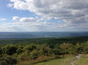
The mountains and valleys of this region were formed about 300–400 million years ago. This happened during the Ordovician period and the Appalachian orogeny, a time of huge pressure that created the Appalachian Mountains. This area makes up about two-thirds of the region. It has long, even ridges with long valleys in between, running from southwest to northeast. This region is mostly made of sedimentary rock.
Kittatinny Mountain is the main mountain feature in the New Jersey parts of the Minisink. It is part of the Appalachian Mountains. It starts in New Jersey as the eastern half of the Delaware Water Gap. It then runs northeast to southwest along the Delaware River. Its height ranges from 1,200 to 1,800 feet (366 to 549 meters). It reaches its highest point at High Point, which is 1,803 feet (550 meters) tall.
Between Kittatinny Mountain and the Delaware River is the Wallpack Ridge. This is a smaller ridge, about 500 to 800 feet (152 to 244 meters) high. It runs parallel to Kittatinny Mountain and encloses the valley of the Flat Brook, also called Walpack Valley.
The Kittatinny Valley is east of Kittatinny Mountain. It is mostly rolling hills and flat valley floors, with heights from 400 to 1,000 feet (122 to 305 meters). This valley is part of the Great Appalachian Valley, which stretches from eastern Canada to northern Alabama.
The valley floor is made of Ordovician Martinsburg Formation (shale and slate) and Jacksonburg Formation (mostly limestone). Kittatinny Mountain itself is made of Silurian Shawangunk Conglomerate, which is mostly quartz. Because quartz is very hard, the mountain resists weathering well.
History of the Minisink
The Lenape People
For thousands of years, different groups of Native Americans lived in this area. When Europeans arrived, the Lenape people, also known as Delaware Indians, lived along the mid-Atlantic coast and inland along the Hudson and Delaware rivers.
After wars like the French and Indian War (1756–1763) and the American Revolutionary War (1775–1783), and later forced removals, many Lenape moved west. Today, main groups of Lenape live in Ontario, Canada, and in Wisconsin and Oklahoma in the United States. In Canada, they are part of the Munsee-Delaware Nation, the Delaware Nation at Moraviantown, and the Delaware of Six Nations. In the United States, they are part of three federally recognized tribes: the Delaware Nation and the Delaware Tribe of Indians in Oklahoma, and the Stockbridge–Munsee Community in Wisconsin. Some groups in New Jersey, like the Ramapough Mountain Indians and the Nanticoke Lenni-Lenape, also identify as Lenape descendants.
The Tocks Island Dam Project
The Delaware River often floods, sometimes from melting snow or heavy rain. In August 1955, record floods happened after two hurricanes, Hurricane Connie and Hurricane Diane, passed over the area in one week. The river rose very high, causing deaths and a lot of damage.
Before these floods, there was already a plan to build a dam near Tocks Island. The 1955 floods made flood control a national issue. The United States Army Corps of Engineers suggested building the dam. It would have created a 37-mile (60-km) long lake between Pennsylvania and New Jersey, up to 140 feet (43 meters) deep. The area around the lake would become the Tocks Island National Recreation Area, managed by the National Park Service. It would offer activities like hunting, hiking, fishing, and boating. Besides flood control and recreation, the dam would also create electricity and provide clean water for New York City and Philadelphia.
Starting in 1960, the government began buying land for the dam project. About 15,000 people were forced to leave their homes along the Delaware River. Around 3,000 to 5,000 homes and other buildings were torn down to prepare for the dam and the flooding of the valley. Many important historical sites were lost.
However, the dam plan faced strong opposition from environmental groups and the people who had been forced to move. There was also not enough government money, and a study showed that building the dam near active fault lines might not be safe. Because of these reasons, the federal government stopped the project in 1978. The land was then given to the National Park Service and became the Delaware Water Gap National Recreation Area.
 | Percy Lavon Julian |
 | Katherine Johnson |
 | George Washington Carver |
 | Annie Easley |


