Wallpack Ridge facts for kids
Quick facts for kids Wallpack Ridge |
|
|---|---|
| Walpack Ridge | |

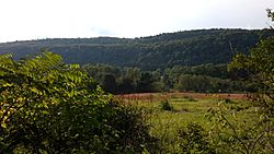
Wallpack Ridge seen from Mountain Road
|
|
| Highest point | |
| Elevation | 928 ft (283 m) |
| Geography | |
| Range coordinates | 41°14′1.234″N 74°51′10.147″W / 41.23367611°N 74.85281861°W |
| Parent range | Kittatinny Mountain |
| Geology | |
| Age of rock | Late Silurian |
| Mountain type | Dendritic ridge |
| Climbing | |
| Access | Restricted access roads |
Wallpack Ridge (also called Walpack Ridge) is a long, narrow mountain in northwestern New Jersey. It is part of the Ridge-and-Valley Appalachians, a special kind of mountain range. This area has many long, parallel ridges and valleys.
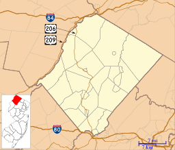
The ridge is located in Sussex County. It stretches for about 25 miles (40 km) from Montague Township down to the Delaware River. Wallpack Ridge is not very wide, ranging from 0.67 miles (1.08 km) to 1.7 miles (2.7 km) across. Its highest point is 928 feet (283 m) above sea level.
Wallpack Ridge separates two valleys: the Wallpack Valley and the valley of the Delaware River. This river valley is also known as the Minisink. The ridge is important because it holds the water system for the Flat Brook and its two main branches, Big Flat Brook and Little Flat Brook.
Contents
Wallpack Ridge: A Natural Landmark
Wallpack Ridge is a significant natural feature in New Jersey. It is known for its unique shape and its role in the local environment. The ridge runs from the northeast to the southwest, creating a distinct line across the landscape.
What is a Ridge?
A ridge is a long, narrow raised section of land. It is usually formed by geological forces over millions of years. Wallpack Ridge is a great example of this type of landform. It stands out from the flatter valleys on either side.
Water Systems of Wallpack Ridge
The ridge plays a key role in the area's water supply. It contains the "watershed" of the Flat Brook. A watershed is an area of land where all the water drains into a common point, like a river or stream. Rain and snow that fall on Wallpack Ridge eventually flow into the Flat Brook and its branches.
History of Wallpack Ridge Land
In the 1950s and 1960s, there was a big plan to build a dam on the Delaware River. This project was called the Tocks Island Dam. If built, it would have created a huge lake. This lake would have flooded the Walpack Valley, which is next to Wallpack Ridge.
The Dam Project and Land Seizure
To build the dam, the government needed a lot of land. The U.S. Army Corps of Engineers took control of land in northwestern New Jersey and northeastern Pennsylvania. Many people who lived there had to leave their homes.
Why the Dam Was Not Built
However, the dam project faced many problems. There were political disagreements and concerns about the geology of the area. Because of these issues, the plan to build the dam was stopped. The land that had been taken was then given to the National Park Service.
Wallpack Ridge Today
In 1978, the National Park Service created the Delaware Water Gap National Recreation Area. Wallpack Ridge is now a part of this special area. This means the land is protected and managed for people to enjoy nature and outdoor activities. It is a place where visitors can explore and learn about the environment.
 | Laphonza Butler |
 | Daisy Bates |
 | Elizabeth Piper Ensley |


