
Kittatinny Mountain facts for kids
Quick facts for kids Kittatinny Mountain |
|
|---|---|

The Kittatinny Valley seen from Sunrise Mountain lookout
|
|
| Highest point | |
| Elevation | 1,803 feet (at High Point) |
| Geography | |
| Location | New Jersey, United States |
| Parent range | Ridge-and-valley Appalachians |
Kittatinny Mountain (in the Lenape language: Kitahtëne) is a long, tall landform called a ridge. It stretches across northwestern New Jersey. This ridge is a natural continuation of Blue Mountain Ridge in Pennsylvania, which is also known as Kittatinny Ridge.
Kittatinny Mountain is the first big ridge you see in the far northeastern part of the Ridge and Valley area of the Appalachian Mountains. Its highest point is High Point, which is also the highest spot in New Jersey! It stands at 1,803 feet (550 meters) tall. Kittatinny Mountain forms the eastern side of the Wallpack Valley. On the western side of this valley, you'll find the Wallpack Ridge.
Contents
Exploring Protected Areas
Most of Kittatinny Mountain is public land, which means it's protected for everyone to enjoy.
- In the far north, you'll find High Point State Park. This park protects the area around High Point, the mountain's tallest peak.
- Further southwest, Stokes State Forest covers a large part of the mountain. It stretches from High Point State Park down to the Delaware Water Gap National Recreation Area.
- The Delaware Water Gap National Recreation Area covers the entire southern half of the mountain. It also includes the smaller Worthington State Forest. This forest protects the southwestern end of the mountain, close to the Delaware Water Gap.
Mountain's Story: Geology

The name "Kittatinny" comes from the Lenape Native American language. It means "endless hill" or "great mountain."
The highest point on the mountain is High Point, at 1,803 feet (550 meters). It's the highest spot in all of New Jersey! You can even drive a road almost to the top of this peak, which is inside High Point State Park. The second highest peak is Sunrise Mountain, located in Stokes State Forest. It's 1,653 feet (504 meters) tall. There's also a road that leads almost to its top.
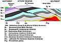
Kittatinny Mountain is made mostly of a very hard rock called Shawangunk Conglomerate. This rock is mainly made of quartz. Because quartz is so tough, the mountain is very strong and doesn't wear away easily from weather.
How the Mountain Was Formed
About 450 million years ago, a chain of volcanic islands crashed into what would become North America. The North American plate slid under these islands. This collision pushed the islands on top of North America's edge. This event created the Highlands and the Kittatinny Valley.
Later, around 400 million years ago, a small continent collided with North America. This caused huge pressure on the land. The pressure made the rock layers bend and break. This bending is called folding, and the breaking is called faulting. During this process, intense heat melted a substance called silica. This silica then glued the quartz and other stones together, making the rock even stronger. This intense heat also allowed the rock layers to bend. That's how Kittatinny Mountain was born!
Mountain Features
Near the bottom of the mountain's west side, you'll find red and green shale and sandstone. On the east side, near the base, there's slate, shale, and sandstone.
The top of the mountain is mostly flat, ranging from 1,400 to 1,600 feet (427 to 488 meters) high. There are two main breaks in this flat top:
- Culver's Gap: This gap was formed by an ancient stream. It's now a "wind gap," meaning the stream is gone. The bottom of Culver's Gap is at least 400 feet (122 meters) below the mountain's top. It's near Culver's Lake, close to Branchville.
- A smaller gap: This is a groove or dip in the ridge south of Catfish Pond. It's about 350 feet (107 meters) deep.
Culver's Gap was an important path for early people, like the Paleo Indians and the Lenape Native Americans. They used it to travel through the mountain for trade and hunting.
The top of the mountain can be as narrow as 50 meters (164 feet) or as wide as 4 miles (6.4 kilometers).
West of Kittatinny Mountain, at its northwestern end, is the Port Jervis trough, also known as the Minisink Valley. Next to the mountain on the western side is the Flatbrook Valley, which runs from Steam Mill to Flatbrookville.
The Delaware River flows near the mountain's south end. It cuts right through the ridge at the Delaware Water Gap, just south of Mount Tammany.
Kittatinny Mountain is part of the Ridge and Valley area of the Appalachian Mountains. In Pennsylvania, this ridge is called Blue Mountain. It continues southwest for about 150 miles (241 kilometers). In New York, the ridge is known as the Shawangunk Mountains, stretching towards Kingston.
Ice Age Impact
About 21,000 BC, a huge sheet of ice called the Wisconsin glacier covered the entire mountain. It melted around 13,000 BC. This glacier left behind interesting landforms like rock fields and kettles (bowl-shaped hollows) at the northern end of the mountain in Stokes State Forest.
After the glacier melted, the area was a cold, treeless Tundra biome. As the climate warmed, it became a Taiga biome, with coniferous trees like spruce and pine. By 8000 BC, the climate was even warmer, and deciduous trees like oak, maple, birch, and willow began to grow.
Ancient Inhabitants: Paleo Indians
The first people to live in the Delaware River Valley were the Paleo Indians. They arrived around 10,500 BC, after the Wisconsin Glacier melted. They hunted, fished, and gathered plants in the Delaware Valley and on Kittatinny Mountain. They didn't have permanent homes but moved around to find food.
As the glacier melted, grasslands appeared, which later turned into forests. Large animals roamed these grasslands, helping the Paleo Indians survive. Around 8000 BC, nut trees began to grow, providing more food. This allowed the Paleo Indian population to slowly grow. Evidence of these ancient animals, like the Marshall Creek Mastodon, has been found nearby. Other big animals like caribou and muskox also lived here.
Native Americans: The Lenape People
The Lenape Native Americans arrived in this area about 2,000 years ago from the Mississippi River valley. They traveled on Kittatinny Mountain to find plant foods and hunt animals. They collected nuts like acorns, walnuts, and chestnuts from the forests. They also drank fresh water from the mountain's streams. The Lenapes hunted deer, elk, and bear on the mountain.
Waterfalls, Cliffs, and Lakes

Kittatinny Mountain has some beautiful natural features:
- Buttermilk Falls: On the western side of the mountain, you'll find Buttermilk Falls. It's about 4 miles (6.4 kilometers) south of US Route 206. A dirt road leads to its base, and there's a wooden staircase to climb to the top.
- Seasonal Falls: Another waterfall appears during heavy rains next to Interstate 80. Water slides over rocks and drops over a small ledge.
- Cliffs: The largest cliff is at the Delaware Water Gap. It's up to 300 feet (91 meters) high and stretches about 400 meters (1,312 feet) along the mountain. A second large cliff is about 6 miles (9.7 kilometers) north of the Gap. Smaller rock faces are found on both sides of the mountain. The southeastern side of the mountain is steeper than the northwestern side.
- Lakes and Ponds: The top of the mountain has 14 lakes and ponds. Some of these include Sunfish Pond, Catfish Pond, Crater Lake, and Lake Marcia. Lake Marcia is the highest lake on the mountain, at 1,574 feet (480 meters) above sea level. It's located in High Point State Park.
Plants and Animals: Flora and Fauna
Kittatinny Mountain is home to a northern deciduous forest. You'll find many types of trees here, such as oaks, hickories, maples, birches, and cherries. Wild blueberries and rhododendrons also grow on the mountain.
Many animals live on the mountain, including:
- Whitetailed deer
- Gray squirrels and red squirrels
- Chipmunks
- Gray fox
- Bobcats
- Beaver
- Black bears
- A wide variety of birds, like Turkey Vultures and Red Tail Hawks.
The lakes are filled with fish like trout, pickerel, and bass.
Mining History
People have tried to mine on Kittatinny Mountain:
- Copper Mining: Copper mining started in the 1750s at the Pahaquarry Copper Mine. This mine is about 8 miles (12.9 kilometers) north of the Delaware Water Gap. The copper ore here was only 2 to 3 percent pure, which made mining very difficult and not profitable. Many companies tried and failed, going bankrupt.
- Silver Mining: In the 1880s, a man named John Snook dug a silver mine in what is now Stokes State Forest. He found silver ore for a short time, but it quickly ran out. The mine is now filled with water.
Kittatinny and Flatbrook Valleys

East of Kittatinny Mountain is the Great Kittatinny Valley. The Paulinskill River drains the southern part of this valley, and the Wallkill River drains the northern part. The Big Flatbrook river drains the northwestern side of the mountain. It flows southwest into the Delaware River. This area is known as the Flatbrook Valley.
The Port Jervis trough is at the northwestern end of the mountain. The Delaware River flows near the mountain's south end. It cuts across the ridge at the Delaware Water Gap, just south of Mount Tammany.
The Kittatinny Mountains are a far northeastern part of the Ridge and Valley area of the Appalachian Mountains. In Pennsylvania, this ridge is called Blue Mountain. It runs southwest for about 150 miles (241 kilometers) towards Maryland. In Franklin County, Pennsylvania, there's another ridge called "Kittatinny Mountain" that runs next to Blue Mountain. The Pennsylvania Turnpike has tunnels through both ridges. To the north in New York, the ridge is known as the Shawangunk Mountains, which goes to Kingston, New York.
Images for kids
-
Kittatinny Mountain cross section

