Branchville, New Jersey facts for kids
Quick facts for kids
Branchville, New Jersey
|
||
|---|---|---|
|
Borough
|
||
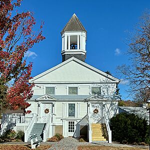
First Presbyterian Church
|
||
|
||
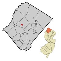
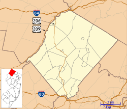
Map of Branchville in Sussex County. Inset: Location of Sussex County in New Jersey.
|
||
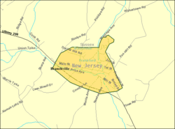
Census Bureau map of Branchville, New Jersey
|
||
| Country | ||
| State | ||
| County | ||
| Incorporated | March 9, 1898 | |
| Named for | Branch of Paulins Kill | |
| Government | ||
| • Type | Borough | |
| • Body | Borough Council | |
| Area | ||
| • Total | 0.60 sq mi (1.55 km2) | |
| • Land | 0.59 sq mi (1.54 km2) | |
| • Water | 0.01 sq mi (0.02 km2) 1.17% | |
| Area rank | 541st of 565 in state 24th of 24 in county |
|
| Elevation | 554 ft (169 m) | |
| Population
(2020)
|
||
| • Total | 791 | |
| • Estimate
(2023)
|
808 | |
| • Rank | 543rd of 565 in state 22nd of 24 in county |
|
| • Density | 1,334.3/sq mi (515.2/km2) | |
| • Density rank | 352nd of 565 in state 5th of 24 in county |
|
| Time zone | UTC−05:00 (Eastern (EST)) | |
| • Summer (DST) | UTC−04:00 (Eastern (EDT)) | |
| ZIP Codes |
07826, 07827, 07890
|
|
| Area code(s) | 973 | |
| FIPS code | 3403707300 | |
| GNIS feature ID | 885168 | |
Branchville is a small town, or borough, located in Sussex County, in the northern part of New Jersey. In 2020, about 791 people lived here. The town was officially created on March 9, 1898. It got its name because it's located near a branch of the Paulins Kill river.
Contents
A Look Back: Branchville's History
Branchville was first settled by people from Connecticut in the 1700s. It grew quickly, and by the 1820s, new building lots were being sold. By 1844, it was a busy community. It had 32 homes, mills, blacksmith shops, a school, a church, and other businesses.
In 1855, two new water-powered mills and a dam were built. These helped the town become even more successful. Later, this dam and another one helped create electricity for Branchville. The town even had its own power company!
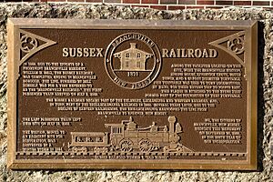
When the Sussex Railroad reached Branchville in 1869, it brought a huge boost to the town's economy. Between 1869 and 1871, forty new homes were built. The railroad made it easy to ship products from local mills and creameries to bigger cities. It also helped tourism grow. Many people from large cities would take the train to Branchville for country vacations. Sometimes, as many as six trains a day would arrive!
Exploring Branchville's Geography
Branchville is a small area, covering about 0.60 square miles. Most of this is land, with a tiny bit of water.
A Town Surrounded: The "Doughnut" Effect
Branchville is special because it's completely surrounded by Frankford Township. Imagine a doughnut: Branchville is the hole, and Frankford Township is the dough around it! This is one of 21 such "doughnut towns" in New Jersey.
Branchville's Climate
Branchville has a climate with big changes between seasons. Summers are warm to hot, and often humid. Winters are cold, sometimes very cold. This type of weather is called a humid continental climate.
The Land Beneath Our Feet: Geology
Branchville sits on a type of rock called the Martinsburg Formation. This rock, made of shale, slate, and limestone, formed about 450 million years ago. This happened when volcanic islands crashed into what would become North America. This collision created the Highlands of Sussex County and the Kittatinny Valley.
Millions of years later, about 400 million years ago, another landmass collided with North America. This created the Kittatinny Mountain. The pressure from this event heated and bonded the rocks together.
About 21,000 to 13,000 years ago, the Wisconsin Glacier covered all of Branchville, even the top of Kittatinny Mountain. As the climate warmed, the glacier melted and retreated. This created many ponds and lakes, including Culver Lake. Branchville's water drains into Culver's Lake Creek and Dry Brook, which eventually flow into the Paulinskill River.
Branchville's Population
| Historical population | |||
|---|---|---|---|
| Census | Pop. | %± | |
| 1900 | 526 | — | |
| 1910 | 663 | 26.0% | |
| 1920 | 588 | −11.3% | |
| 1930 | 665 | 13.1% | |
| 1940 | 715 | 7.5% | |
| 1950 | 810 | 13.3% | |
| 1960 | 963 | 18.9% | |
| 1970 | 911 | −5.4% | |
| 1980 | 870 | −4.5% | |
| 1990 | 851 | −2.2% | |
| 2000 | 845 | −0.7% | |
| 2010 | 841 | −0.5% | |
| 2020 | 791 | −5.9% | |
| 2023 (est.) | 808 | −3.9% | |
| Population sources: 1900–1920 1900–1910 1910–1930 1940–2000 2010 2020 |
|||
In 2010, Branchville had 841 residents. By 2020, the population had slightly decreased to 791 people. Most residents were White (96.43%). About 22.8% of the population was under 18 years old. The average age in Branchville was 42.8 years.
Branchville's Economy
One important business in Branchville is Selective Insurance. This company provides different types of insurance and has its main office here.
Learning in Branchville: Education
Students in Branchville attend public schools through a special arrangement.
- For students in pre-kindergarten through eighth grade, they go to schools in the Frankford Township School District. This district has one school located right in Branchville. In the 2021-22 school year, there were about 505 students.
- For ninth through twelfth grade (high school), students from Branchville attend High Point Regional High School. Students from several other nearby townships also go to this high school. In the 2021-22 school year, the high school had about 812 students.
Getting Around: Transportation
As of 2014, Branchville had about 6.30 miles of roads. Some roads are kept up by the town, some by Sussex County, and some by the state of New Jersey.
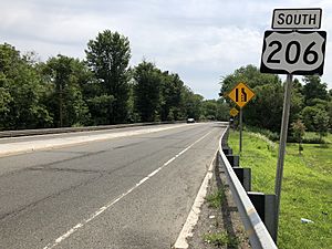
The main highway that goes through Branchville is U.S. Route 206. County Route 519 also passes through the borough.
Famous Faces: Notable People
People who have lived in or are connected to Branchville include:
- David Zabriskie (born 1986), a retired amateur wrestler and current wrestling coach.
See also
 In Spanish: Branchville (Nueva Jersey) para niños
 | Valerie Thomas |
 | Frederick McKinley Jones |
 | George Edward Alcorn Jr. |
 | Thomas Mensah |


