Minisink, New York facts for kids
Quick facts for kids
Minisink, New York
|
|
|---|---|
| Town of Minisink | |

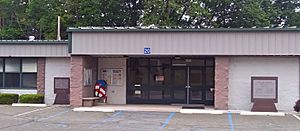
Town hall
|
|

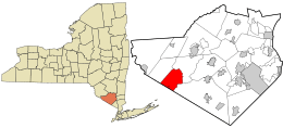
Location in Orange County and the state of New York.
|
|
| Country | United States |
| State | New York |
| County | Orange |
| Area | |
| • Total | 23.14 sq mi (59.95 km2) |
| • Land | 23.00 sq mi (59.57 km2) |
| • Water | 0.14 sq mi (0.37 km2) |
| Elevation | 554 ft (169 m) |
| Population
(2020)
|
|
| • Total | 4,621 |
| • Density | 199.70/sq mi (77.081/km2) |
| Time zone | UTC-5 (EST) |
| • Summer (DST) | UTC-4 (EDT) |
| FIPS code | 36-47713 |
| GNIS feature ID | 0979226 |
Minisink is a small town in the southwestern part of Orange County, New York. It is located in the United States, close to the border of New Jersey. The town sits between the Town of Greenville and the Town of Warwick.
In 2020, about 4,621 people lived in Minisink. The town is easy to reach, being near major roads like Interstate 84 and New York State Route 17. It's also roughly halfway between big cities like New York City and Scranton, Pennsylvania. Minisink has a long and interesting past. It is one of the oldest places settled in this area. Its history goes back to the early 1700s with a large land grant called the Minisink Patent. The town's identity is shaped by its Lenape Native American roots and early European settlers.
Contents
A Look Back at Minisink's History
The name Minisink has a long history. It was first used in the mid-1600s for a much larger area. This area stretched far north to Minisink Ford. It also went south to the Delaware Water Gap. The land covered areas from the Kittatinny Ridge in the east to the Pocono Mountains in the west.
How Minisink Got Its Name
The "Minisink Patent" was a special land grant given in 1704. This grant covered a huge area, much bigger than the town of Minisink today. The town's current boundaries were set in 1800. Things were a bit confusing because the New York-New Jersey border used to be different. Minisink was even part of New Jersey at one point!
Growing and Changing Borders
Europeans first settled in this area around 1725. After the American Revolutionary War, Minisink became an official town in 1788. Over the years, Minisink lost some of its land. This happened as new towns were formed. These included Deerpark (in 1798), Wawayanda (in 1849), and Greenville (in 1853). In 1871, the community of Unionville became its own village, separate from the town.
Where is Minisink Located?
The United States Census Bureau says Minisink covers about 23.2 square miles (59.95 square kilometers). Most of this area, about 23.1 square miles (59.57 square kilometers), is land. A small part, about 0.1 square miles (0.37 square kilometers), is water.
The southern edge of Minisink touches the border of New Jersey. Specifically, it borders Sussex County in New Jersey. NY-284 is a main road that runs north and south through the town.
Who Lives in Minisink?
| Historical population | |||
|---|---|---|---|
| Census | Pop. | %± | |
| 1820 | 5,053 | — | |
| 1830 | 4,979 | −1.5% | |
| 1840 | 5,093 | 2.3% | |
| 1850 | 4,972 | −2.4% | |
| 1860 | 1,266 | −74.5% | |
| 1870 | 1,443 | 14.0% | |
| 1880 | 1,360 | −5.8% | |
| 1890 | 1,269 | −6.7% | |
| 1900 | 1,505 | 18.6% | |
| 1910 | 1,304 | −13.4% | |
| 1920 | 1,252 | −4.0% | |
| 1930 | 1,360 | 8.6% | |
| 1940 | 1,343 | −1.2% | |
| 1950 | 1,367 | 1.8% | |
| 1960 | 1,433 | 4.8% | |
| 1970 | 1,942 | 35.5% | |
| 1980 | 2,488 | 28.1% | |
| 1990 | 2,981 | 19.8% | |
| 2000 | 3,585 | 20.3% | |
| 2010 | 4,490 | 25.2% | |
| 2020 | 4,621 | 2.9% | |
| U.S. Decennial Census | |||
In the year 2000, there were 3,585 people living in Minisink. These people made up 1,182 households, with 945 of them being families. The town had about 155 people per square mile. There were also 1,245 homes in the area.
Minisink's Diverse Community
Most people in Minisink in 2000 were white (89.00%). There were also African American (1.42%), Native American (0.03%), and Asian (0.59%) residents. Some people identified as Hispanic or Latino (10.60%).
Families and Households
Many households (44.8%) in Minisink had children under 18 living there. Most households (69.3%) were married couples living together. About 7.6% had a female head of household without a husband. About 20.0% were not families.
The average household had about 3 people. The average family had about 3.39 people. The population was spread out by age. About 29.8% were under 18. About 31.3% were between 25 and 44 years old. The average age in Minisink was 36 years.
Learning in Minisink
Students in Minisink attend schools in the Minisink Valley Central School District. This district provides education for children living in the town.
Places to Explore in Minisink
Minisink has several smaller communities and interesting spots:
- Johnson – This is a small community found near the northern border of the town. It is located on the NY-284 highway.
- Laurel Hill – This is a higher area, or elevation, located in the eastern part of Minisink.
- Millsburg – Another location situated near the northern edge of the town.
- Unionville – This is a village close to the New Jersey border. It is also on the NY-284 highway.
- Waterloo Mills – A small community located northwest of Westtown.
- Westtown – This is a community north of Unionville. It can be found on NY-284 and County Road 1.
See also
 In Spanish: Minisink para niños
 | Claudette Colvin |
 | Myrlie Evers-Williams |
 | Alberta Odell Jones |


