Greenville, Orange County, New York facts for kids
Quick facts for kids
Greenville, New York
|
|
|---|---|
| Town of Greenville | |

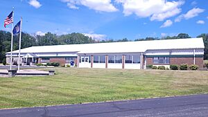
Town hall
|
|

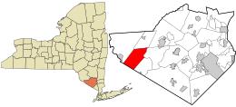
Location in Orange County and the state of New York.
|
|
| Country | United States |
| State | New York |
| County | Orange |
| Government | |
| • Type | Town Council |
| Area | |
| • Total | 30.5 sq mi (79.1 km2) |
| • Land | 30.3 sq mi (78.4 km2) |
| • Water | 0.3 sq mi (0.7 km2) |
| Elevation | 981 ft (299 m) |
| Population
(2020)
|
|
| • Total | 4,689 |
| • Density | 153.74/sq mi (59.28/km2) |
| Time zone | UTC-5 (EST) |
| • Summer (DST) | UTC-4 (EDT) |
| ZIP Code |
10940, 12771
|
| Area code(s) | 845 |
| FIPS code | 36-30631 |
| GNIS feature ID | 0979023 |
Greenville is a small town in Orange County, New York, United States. It is located right along the southern border of the county and the state. In 2020, about 4,689 people lived there.
Greenville does not have any big cities or villages. Most of its communities are just small groups of houses. People living in Greenville get their mail through the Port Jervis or Middletown post offices. You can find Greenville near Exit 4 off Interstate 84. This area has the town's firehouse and a few other businesses.
Contents
History of Greenville
The oldest community in Greenville is called Smiths Corners. It was named after Elijah Smith. This area was settled around the end of the Revolutionary War. People first started settling here in 1750.
Building work began in 1754 but stopped when money from the government was no longer available. Construction didn't start again until the late 1790s. The town of Greenville officially separated from Minisink in 1853.
Geography of Greenville
Greenville covers a total area of about 30.5 square miles (79.1 square kilometers). Most of this area, about 30.3 square miles (78.4 square kilometers), is land. Only a small part, about 0.3 square miles (0.7 square kilometers), is water.
US 6, also known as the Grand Army of the Republic Highway, is an important road that runs east to west through the town. Interstate 84 runs alongside US 6 in Greenville.
The southern border of the town is also the state line with New Jersey.
Population Changes in Greenville
| Historical population | |||
|---|---|---|---|
| Census | Pop. | %± | |
| 1860 | 1,198 | — | |
| 1870 | 1,123 | −6.3% | |
| 1880 | 1,002 | −10.8% | |
| 1890 | 862 | −14.0% | |
| 1900 | 800 | −7.2% | |
| 1910 | 644 | −19.5% | |
| 1920 | 618 | −4.0% | |
| 1930 | 674 | 9.1% | |
| 1940 | 732 | 8.6% | |
| 1950 | 737 | 0.7% | |
| 1960 | 890 | 20.8% | |
| 1970 | 1,379 | 54.9% | |
| 1980 | 2,085 | 51.2% | |
| 1990 | 3,120 | 49.6% | |
| 2000 | 3,800 | 21.8% | |
| 2010 | 4,616 | 21.5% | |
| 2020 | 4,689 | 1.6% | |
| U.S. Decennial Census | |||
In 2000, there were 3,800 people living in Greenville. The population has grown quite a bit over the years. By 2020, the population reached 4,689 people.
The average age of people in Greenville in 2000 was 36 years old. About 30.3% of the population was under 18 years old.
Communities and Locations in Greenville
Here are some of the small communities and places you can find in Greenville:
- Bushville – This is a small community located on US-6, to the east of the Greenville village area.
- Greenville (formerly "Minisink") – This is the main community area, located south of Smiths Corners. It's near where US-6 and Interstate 84 meet.
- Lake Hathorne – A small lake found north of Smiths Corners.
- Logtown – Another small community located southeast of the Logtown area itself.
- Smiths Corners – A community located near the intersection of Interstate 84 and US-6. This is one of the oldest settled areas.
Notable Person
- Christian Eckes, a professional race car driver.
See also
 In Spanish: Greenville (condado de Orange, Nueva York) para niños
 | Roy Wilkins |
 | John Lewis |
 | Linda Carol Brown |


