
Clinton County, New York facts for kids
Quick facts for kids
Clinton County
|
|||
|---|---|---|---|

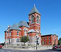
Clinton County Courthouse
|
|||
|
|||

Location within the U.S. state of New York
|
|||
 New York's location within the U.S. |
|||
| Country | |||
| State | |||
| Founded | 1788 | ||
| Named for | George Clinton | ||
| Seat | Plattsburgh | ||
| Largest city | Plattsburgh | ||
| Area | |||
| • Total | 1,117.53 sq mi (2,894.4 km2) | ||
| • Land | 1,037.85 sq mi (2,688.0 km2) | ||
| • Water | 80 sq mi (200 km2) 7.1% | ||
| Population
(2020)
|
|||
| • Total | 79,843 |
||
| • Density | 71/sq mi (27/km2) | ||
| Time zone | UTC−5 (Eastern) | ||
| • Summer (DST) | UTC−4 (EDT) | ||
| Congressional district | 21st | ||


Clinton County is a special place in the very northeast corner of New York State. It shares a border with Quebec, a province in Canada. To its east, across Lake Champlain, is the state of Vermont.
In 2020, about 79,843 people lived here. The main city and county seat is Plattsburgh. The county is named after George Clinton. He was the very first Governor of New York. Later, he became the Vice President. He was also one of the Founding Fathers of the United States.
Contents
History of Clinton County
.png)
When New York State first created counties in 1683, the area that is now Clinton County was part of a huge county called Albany County. This original Albany County was enormous! It covered most of northern New York. It even included all of what is now Vermont.
Over time, this large county was divided into smaller ones.
- In 1784, a county called Charlotte County was renamed Washington County. This was done to honor George Washington, who was a hero of the American Revolutionary War. He later became the first President of the United States.
- Then, in 1788, Clinton County was officially formed. It was created from a part of Washington County.
- Later, other counties were formed from parts of Clinton County. Essex County was created in 1799.
- In 1802, parts of Clinton, Herkimer, and Montgomery counties joined to form St. Lawrence County.
- Finally, in 1808, Franklin County was also created from a part of Clinton County.
Geography of Clinton County
Clinton County is right at the northeast tip of New York State. Its northern edge touches the Canadian province of Quebec. Its eastern edge is next to Vermont, across Lake Champlain. This whole area is often called the Adirondack Coast.
Several rivers flow through the county. The Saranac River flows east and empties into Lake Champlain at Plattsburgh. The Great Chazy River flows northeast into Lake Champlain at Coopersville. The Ausable River forms a big part of the county's southern border.
The highest point in Clinton County is Lyon Mountain. It is located in the town of Dannemora. This mountain is about 3,830 feet (1,167 meters) high. The county covers a total area of about 1,117.53 square miles (2,894.4 km²). Most of this is land, with about 7.1% being water.
Neighboring Areas
Clinton County is next to several other counties and regions:
- Grand Isle County, Vermont — to the east
- Chittenden County, Vermont — to the southeast
- Essex County — to the south
- Franklin County — to the west
- Le Haut-Richelieu Regional County Municipality, Quebec — to the north (in Canada)
- Le Haut-Saint-Laurent Regional County Municipality, Quebec — to the north (in Canada)
- Les Jardins-de-Napierville Regional County Municipality, Quebec — to the north (in Canada)
Protected Natural Areas
Clinton County has many beautiful natural spots. These areas are protected to preserve their beauty and wildlife.
- Adirondack Park (a large part of it)
- Ausable Marsh Wildlife Management Area
- Cadyville State Forest
- Chazy Fossil Reef National Natural Landmark (part of it)
- Dannemora State Forest
- Dunkin's Reserve State Forest
- Flat Rock State Forest
- Kings Bay Wildlife Management Area
- Macomb State Forest
- Miner Lake State Park
- Monty's Bay Wildlife Management Area
- Point au Roche State Park
- Valcour Island
Lakes in the County
Many lakes and ponds are found within Clinton County:
- Chazy Lake
- Fern Lake
- Lake Champlain (along the eastern border)
- Mead Reservoir
- Military Pond
- Miner Lake
- Mud Pond
- Newberry Pond
- Patterson Reservoir
- Silver Lake
- Slush Pond
- Taylor Pond
- Union Falls Pond (part of it)
- Upper Chateaugay Lake
Population Changes
The population of Clinton County has changed a lot over the years. Here's how it has grown and shrunk since 1790:
| Historical population | |||
|---|---|---|---|
| Census | Pop. | %± | |
| 1790 | 1,615 | — | |
| 1800 | 8,514 | 427.2% | |
| 1810 | 8,002 | −6.0% | |
| 1820 | 12,070 | 50.8% | |
| 1830 | 19,344 | 60.3% | |
| 1840 | 28,157 | 45.6% | |
| 1850 | 40,047 | 42.2% | |
| 1860 | 45,735 | 14.2% | |
| 1870 | 47,947 | 4.8% | |
| 1880 | 50,897 | 6.2% | |
| 1890 | 46,437 | −8.8% | |
| 1900 | 47,430 | 2.1% | |
| 1910 | 48,230 | 1.7% | |
| 1920 | 43,898 | −9.0% | |
| 1930 | 46,687 | 6.4% | |
| 1940 | 54,006 | 15.7% | |
| 1950 | 53,622 | −0.7% | |
| 1960 | 72,722 | 35.6% | |
| 1970 | 72,934 | 0.3% | |
| 1980 | 80,750 | 10.7% | |
| 1990 | 85,969 | 6.5% | |
| 2000 | 79,894 | −7.1% | |
| 2010 | 82,128 | 2.8% | |
| 2020 | 79,843 | −2.8% | |
| US Decennial Census 1790-1960 1900-1990 1990-2000 2010-2020 |
|||
As you can see, the population has generally increased over time. There were some dips, like in 1810 or 1920. The highest population recorded was in 1990, with 85,969 people. In 2020, the population was 79,843.
Education
Clinton County has several school districts that serve its students:
- AuSable Valley Central School District
- Beekmantown Central School District
- Chateaugay Central School District
- Chazy Union Free School District
- Northeastern Clinton Central School District
- Northern Adirondack Central School District
- Peru Central School District
- Plattsburgh City School District
- Saranac Central School District
- Saranac Lake Central School District
For higher education, the State University of New York at Plattsburgh is located in the City of Plattsburgh. There is also Clinton Community College, which is in the Town of Plattsburgh.
Important Buildings and Facilities
Clinton County is home to some important facilities. The Clinton Correctional Facility is a large prison located in the village of Dannemora. There is also the Altona Correctional Facility in the town of Altona.
Transportation
Getting around Clinton County is easy with various transportation options.
Highways
Several major roads run through the county, connecting it to other parts of New York and Canada.
- Interstate 87 - runs north to south, going all the way to the Canadian border.
- US-2
- US-9
- US-11
- NY-3
- NY-9N
- NY-22
- NY-22B
- NY-190
- NY-191
- NY-374
- NY-442
- NY-456
Airports
For air travel, Clinton County has a few airports:
- Plattsburgh International Airport (PBG) – in Plattsburgh
- Clinton County Airport (PLB) – also in Plattsburgh
- Rouses Point Seaplane Base (K21) – in Rouses Point (for seaplanes)
Train Travel
The Amtrak Adirondack Train travels through Clinton County. This train connects the city of Montreal in Canada to New York City. It stops twice a day in the county, once heading north and once heading south. You can catch the train at the Plattsburgh and Rouses Point stops.
Local Buses
The Clinton County Public Transit system offers bus routes. These buses start in Plattsburgh and travel to different towns throughout the county, helping people get around.
Communities
Clinton County has many towns, villages, and smaller communities.
Larger Towns and Villages
Here are some of the bigger places where people live in Clinton County:
| # | Location | Population | Type | Area |
|---|---|---|---|---|
| 1 | †Plattsburgh | 19,989 | City | Champlain Shore |
| 2 | Dannemora | 3,936 | Village | Mainland |
| 3 | Rouses Point | 2,209 | Village | Champlain Shore |
| 4 | ‡Keeseville | 1,815 | CDP | Adirondack Park |
| 5 | Cumberland Head | 1,627 | CDP | Champlain Shore |
| 6 | Peru | 1,591 | CDP | Adirondack Park |
| 7 | Morrisonville | 1,545 | CDP | Mainland |
| 8 | Plattsburgh West | 1,364 | CDP | Mainland |
| 9 | Champlain | 1,101 | Village | Mainland |
| 10 | Altona | 730 | CDP | Mainland |
| 11 | Chazy | 565 | CDP | Champlain Shore |
| 12 | Au Sable Forks | 559 | CDP | Adirondack Park |
| 13 | West Chazy | 529 | CDP | Mainland |
| 14 | Cadyville | 479 | CDP | Mainland |
| 15 | Redford | 477 | CDP | Adirondack Park |
| 16 | ††Mooers | 442 | CDP | Mainland |
| 17 | Lyon Mountain | 423 | CDP | Adirondack Park |
| 18 | Parc | 254 | CDP | Champlain Shore |
† - This is the county seat, the main city for county government.
†† - This used to be a village but is now a Census Designated Place (CDP).
‡ - This community is not entirely within Clinton County.
Towns in Clinton County
Clinton County is divided into several towns:
Smaller Communities (Hamlets)
These are even smaller communities within the towns:
- Churubusco
- Coopersville
- Swastika
- Morrisonville
See also
In Spanish: Condado de Clinton (Nueva York) para niños
Images for kids
-
Clinton County Courthouse
