Peru, New York facts for kids
Quick facts for kids
Peru, New York
|
|
|---|---|
 |
|

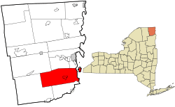
Location in Clinton County and the state of New York
|
|
| Country | United States |
| State | New York |
| County | Clinton |
| Government | |
| • Type | Town Council |
| Area | |
| • Total | 92.38 sq mi (239.26 km2) |
| • Land | 78.89 sq mi (204.32 km2) |
| • Water | 13.49 sq mi (34.94 km2) |
| Elevation | 436 ft (133 m) |
| Population
(2020)
|
|
| • Total | 6,772 |
| • Density | 88.54/sq mi (34.19/km2) |
| Time zone | UTC-5 (Eastern (EST)) |
| • Summer (DST) | UTC-4 (EDT) |
| ZIP code |
12972
|
| Area code(s) | 518 |
| FIPS code | 36-019-57375 |
| GNIS feature ID | 0979358 |
Peru is a small town located in Clinton County, in the state of New York. In 2020, about 6,772 people lived here. The town was named Peru because its beautiful views of the Adirondack Mountains and its many farms reminded early settlers of the country of Peru in South America. Peru, New York, is in the southeastern part of Clinton County, just south of the city of Plattsburgh.
Contents
Exploring Peru's Past
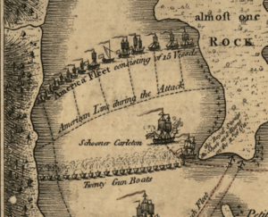
The first people settled in this area in 1772. A very important event, the Battle of Valcour Island, happened in 1776. This battle was fought in Lake Champlain, which is on the eastern side of Peru. It was a key naval battle during the American Revolutionary War.
The town of Peru was officially created in 1792. It was formed from parts of two other towns: Plattsburgh and Willsboro. Later, in 1799, a small part of Peru was given back to Willsboro. In 1838, Peru was divided again to create two new towns, Au Sable and Black Brook.
On April 20, 2002, a moderate earthquake with a strength of 5.2 happened in western Peru. It was about 15 miles (24 km) southwest of Plattsburgh. Luckily, it caused only minor damage.
Peru's Location and Landscape
Peru covers a total area of about 92.4 square miles (239.3 square kilometers). Most of this area, about 78.9 square miles (204.3 square kilometers), is land. The rest, about 13.5 square miles (34.9 square kilometers), is water.
The eastern side of Peru borders Lake Champlain. The middle of the lake forms the state line between New York and Vermont. The Ausable River makes up part of Peru's southern border. The Little Ausable River also flows east through the southern part of the town.
Major roads run through Peru. The Adirondack Northway (Interstate 87) and U.S. Route 9 are highways that go north and south. Other state routes like New York State Route 22, New York State Route 22B, and New York State Route 442 (also called Bear Swamp Road) meet in Peru village.
Who Lives in Peru: Population Facts
| Historical population | |||
|---|---|---|---|
| Census | Pop. | %± | |
| 1820 | 2,710 | — | |
| 1830 | 4,949 | 82.6% | |
| 1840 | 3,134 | −36.7% | |
| 1850 | 3,640 | 16.1% | |
| 1860 | 3,389 | −6.9% | |
| 1870 | 2,632 | −22.3% | |
| 1880 | 2,610 | −0.8% | |
| 1890 | 2,356 | −9.7% | |
| 1900 | 2,372 | 0.7% | |
| 1910 | 2,236 | −5.7% | |
| 1920 | 2,000 | −10.6% | |
| 1930 | 1,989 | −0.5% | |
| 1940 | 2,287 | 15.0% | |
| 1950 | 2,348 | 2.7% | |
| 1960 | 3,110 | 32.5% | |
| 1970 | 4,312 | 38.6% | |
| 1980 | 5,352 | 24.1% | |
| 1990 | 6,254 | 16.9% | |
| 2000 | 6,370 | 1.9% | |
| 2010 | 6,998 | 9.9% | |
| 2020 | 6,772 | −3.2% | |
| U.S. Decennial Census | |||
In 2000, there were 6,370 people living in Peru. These people lived in 2,309 households, and 1,777 of those were families. The population density was about 80 people per square mile (31 people per square kilometer).
Most people in Peru were White (97.22%). Other groups included Black (0.91%), Native American (0.08%), and Asian (0.61%). About 0.85% of the population was Hispanic or Latino.
The average household had about 2.73 people, and the average family had about 3.07 people. About 39.2% of households had children under 18 living with them.
The median age in the town was 37 years old. This means half the people were younger than 37, and half were older. About 28.3% of the population was under 18 years old.
Towns and Places in Peru
Peru has several smaller communities and interesting spots:
- Clark Corners – A small area located to the west of Peru village.
- Coffey Corners – Found near the northern border of the town, north of Peru village.
- Cromie Corners – An area located northwest of Peru village.
- Day Point – A spot on the shore of Lake Champlain, directly across from Valcour Island.
- Lapham's Mills (once called "Bartonville") – A small village northeast of Peru village, close to the Northway highway.
- Macomb Reservation State Park – A state park located at the northern edge of the town.
- Peasleeville – A location found west of the main town area.
- Peru – This is the main hamlet or village of Peru. It's where NY Route 22 and NY Route 22B meet in the east-central part of the town. It was first settled around 1795.
- South Junction – A small village at the northeastern border of the town.
- Valcour (formerly "Port Valcour") – A village on the shore of Lake Champlain, along US-9.
- Valcour Island – Most of this island (about 80%) in Lake Champlain is part of the town of Peru.
Famous People from Peru
Some notable individuals have connections to Peru:
- Asa Adgate (1767–1832) – He was a congressman from New York and held several local government jobs in Peru.
- Frances Elizabeth "Fran" Allen (1932–2020) – A famous IBM computer scientist who grew up in Peru.
- Charles H. Anson (1841–1928) – A Wisconsin state politician and businessman who was born in Peru.
- Frank A. Anson (1844–1909) – Also a Wisconsin state politician and businessman, and Charles's brother, born in Peru.
- James Henry Lockwood (1793–1857) – A lawyer, fur trapper, and merchant.
- Francis A. Pratt (1827–1902) – A mechanical engineer, inventor, and one of the founders of the well-known company Pratt & Whitney.
See also
 In Spanish: Peru (Nueva York) para niños
 | Madam C. J. Walker |
 | Janet Emerson Bashen |
 | Annie Turnbo Malone |
 | Maggie L. Walker |


