
Ausable River (New York) facts for kids

The Ausable River is a beautiful river in New York. It starts high up in the Adirondack Mountains. The river flows past towns like Lake Placid and Au Sable Forks. Finally, it empties into Lake Champlain (at 44°33′40″N 73°25′25″W / 44.56111°N 73.42361°W). The Ausable River is special because it has two main parts: the East Branch and the West Branch. They meet up at Au Sable Forks. This river also forms part of the border between Clinton County and Essex County. A very famous spot on the river is the gorge called Ausable Chasm, which is near Keeseville.
The Ausable River is about 94 miles (151 kilometers) long. It drains an area of about 516 square miles (1,336 square kilometers). This means it collects water from a large region.
The river was first named "Au Sable" by Samuel de Champlain in 1609. He was exploring the area at the time. "Au Sable" is French for "sandy," and he chose this name because the river has a very large sandy delta where it meets Lake Champlain.
Exploring the West Branch of the Ausable River
The West Branch of the Ausable River begins where three smaller streams meet. These streams are called MacIntyre, South Meadow, and Marcy Brooks. This meeting point is east of Mount Jo, near the Adirondak Loj. From there, the West Branch flows northeast for about 36 miles (58 kilometers) until it reaches Au Sable Forks (44°26′25″N 73°40′28″W / 44.44028°N 73.67444°W).
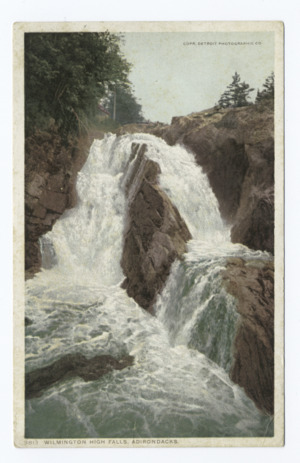
Along its journey, the West Branch gets more water from Lake Placid and the Chubb River. When there's a lot of water, the upper part of this branch is great for exciting white-water paddling. Further down, the river flows through a stunning place called High Falls Gorge at the Wilmington Notch. This gorge was formed by a crack in the Earth's crust. It has cliffs that are 700 feet (213 meters) high on one side and 1,700 feet (518 meters) high on the other!
Discovering the East Branch of the Ausable River
The East Branch of the Ausable River starts from two lakes: Upper and Lower Ausable lakes. These lakes are located in the Ausable Valley, which forms the southern side of the Great Range of mountains. The first 4 miles (6 kilometers) of this branch are especially beautiful. You can see them from hiking trails on both sides of the river. These trails are kept in good condition by the Adirondack Trail Improvement Society.
Later, the East Branch meets another stream called Cascade Brook. This brook flows from the Cascade Lakes, which are located beneath Cascade Mountain. Finally, the East Branch continues its journey to meet the West Branch at Au Sable Forks.
