
Keeseville, New York facts for kids
Quick facts for kids
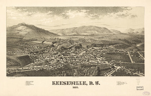
Keeseville, New York
|
|
|---|---|
|
Hamlet and CDP
|
|

Richard Keese II house (1823)
|
|

Location in Clinton County and the state of New York.
|
|
| Country | United States |
| State | New York |
| Counties | Clinton, Essex |
| Towns | Au Sable and Chesterfield |
| Incorporated | May 1878 |
| Dissolved | December 31, 2014 |
| Area | |
| • Total | 6.13 sq mi (15.88 km2) |
| • Land | 6.02 sq mi (15.59 km2) |
| • Water | 0.11 sq mi (0.29 km2) |
| Elevation | 417 ft (127 m) |
| Population
(2020)
|
|
| • Total | 2,931 |
| • Density | 486.88/sq mi (187.98/km2) |
| Time zone | UTC-5 (Eastern (EST)) |
| • Summer (DST) | UTC-4 (EDT) |
| ZIP Code |
12944
|
| Area code(s) | 518 |
| FIPS code | 36-39089 |
| GNIS feature ID | 2390918 |
Keeseville is a small community, called a hamlet, located in New York State. It's found in both Clinton and Essex counties. In 2020, about 2,931 people lived there.
The hamlet was named after the Keese family, who were early settlers from Vermont. Keeseville grew along the Ausable River. The river's strong current provided power for mills and helped industries develop.
Keeseville is part of the towns of Au Sable and Chesterfield. It is located south of the city of Plattsburgh. The hamlet is also inside the Adirondack Park, a large protected area established in the 20th century.
In 2013, the local board decided to dissolve Keeseville as a village. This means it is no longer its own separate village government. The change officially happened on December 31, 2014.
Contents
History of Keeseville
Keeseville was first called "Anderson Falls" by settlers from New England. These settlers moved into the area after the American Revolutionary War. The name changed around 1812 to "Keeseville," honoring a local business owner named Keese.
Early Industries and Growth
In its early days, Keeseville was an industrial hub. It was known for lumber, iron processing, and milling. One important factory was the Ausable Chasm Horse Nail Works. This factory made two tons of nails every day from 1863 to 1925.
Many people of French Canadian background also settled in Keeseville. They have strong historical ties to the area. For example, St. John's Catholic Church was designed in a French style. As people moved west or to bigger cities, the population of Keeseville slowly decreased.
Railroad and Local News
The Keeseville, Ausable Chasm & Lake Champlain Railroad was a short train line. It connected Port Kent steamships and the Delaware & Hudson Railroad to the Ausable Chasm and local businesses. This railroad, nicknamed the "Peanut RR," operated from 1890 until 1924. It was 5.6 miles long and used the standard train track width. The old train station, which later became a restaurant, received a historic marker in 2018. You can learn more about local history at the Anderson Falls Heritage Society in Keeseville.
The Essex County Republican newspaper, which started in Port Henry, moved to Keeseville in the 20th century. It then became known as the Keeseville Essex County Republican.
Village Dissolution
In January 2013, people in Keeseville voted to dissolve the village. This means the village government would no longer exist. The vote was 268 in favor and 176 against. The areas that were part of the village now fall under the control of the two towns it is located in. These towns now provide services and local government. The village officially dissolved on December 31, 2014.
Historic Landmarks
Several important places in Keeseville are listed on the National Register of Historic Places. These include the Double-Span Metal Pratt Truss Bridge, the Keeseville Historic District, Rembrandt Hall, the Stone Arch Bridge, the Swing Bridge, and the Tomlinson House.
Geography of Keeseville
Keeseville is located at coordinates 44°30′13″N 73°28′52″W. It is south of Plattsburgh and just west of Lake Champlain. The hamlet is also within the Adirondack Park.
Ausable River and Chasm
The Ausable River flows through Keeseville. This river also forms the border between Clinton and Essex counties. The northern part of Keeseville is in the Town of Au Sable in Clinton County. The southern part is in the Town of Chesterfield in Essex County. North of the hamlet, the Ausable River has carved a deep, 2-mile-long gorge called Ausable Chasm. This chasm is a very popular place for tourists to visit.
Area and Roads
According to the United States Census Bureau, Keeseville covers a total area of about 3.2 square kilometers (1.2 square miles). Most of this area, about 3.0 square kilometers (1.2 square miles), is land. A small part, about 0.1 square kilometers (0.04 square miles), is water.
Keeseville is a meeting point for several important roads. These include US Route 9, New York State Route 22, and New York State Route 9N. Several Essex County Roads also meet here. Interstate 87, also known as the Northway, passes west of Keeseville. You can get to Keeseville from Exit 34 (NY 9N) on Interstate 87.
Population and People
| Historical population | |||
|---|---|---|---|
| Census | Pop. | %± | |
| 1880 | 2,181 | — | |
| 1890 | 2,103 | −3.6% | |
| 1900 | 2,110 | 0.3% | |
| 1910 | 1,835 | −13.0% | |
| 1920 | 1,524 | −16.9% | |
| 1930 | 1,794 | 17.7% | |
| 1940 | 1,921 | 7.1% | |
| 1950 | 1,977 | 2.9% | |
| 1960 | 2,213 | 11.9% | |
| 1970 | 2,122 | −4.1% | |
| 1980 | 2,025 | −4.6% | |
| 1990 | 1,854 | −8.4% | |
| 2000 | 1,850 | −0.2% | |
| 2010 | 1,815 | −1.9% | |
| 2020 | 2,931 | 61.5% | |
| U.S. Decennial Census | |||
In 2000, there were 1,850 people living in Keeseville. About 34.4% of households had children under 18. The average household had 2.57 people. The median age in Keeseville was 36 years old. About 27.1% of the population was under 18.
The median income for a household in Keeseville was $32,813. For families, the median income was $36,181. About 15.3% of the population lived below the poverty line. This included 21.5% of those under 18.
Education
Keeseville is part of the AuSable Valley Central School District. This school district serves the students in the area.
Notable People from Keeseville

Keeseville is the birthplace of some interesting people.
- William Henry Jackson (born April 4, 1843) became a famous photographer. He took many pictures of the American frontier and the Civil War. He was also a talented painter. Jackson joined the U.S. Army in 1862 and was at the Battle of Gettysburg. His photographs of the American frontier are well-known, and his old glass negatives are kept in museums.
- Julia H. Thayer (1847-1944) was a poet and educator.
- Architect Isaac G. Perry also lived in Keeseville. He designed many churches and public buildings in upstate New York in the late 1800s. Many of his buildings are now listed on the National Register of Historic Places.
See also
 In Spanish: Keeseville para niños
