
Chesterfield, New York facts for kids
Quick facts for kids
Chesterfield, New York
|
|
|---|---|

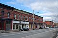
Hamlet and CDP of Keeseville in Chesterfield
|
|

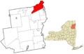
Location in Essex County and the state of New York
|
|
| Country | United States |
| State | New York |
| County | Essex |
| Government | |
| • Type | Town Council |
| Area | |
| • Total | 105.37 sq mi (272.91 km2) |
| • Land | 79.03 sq mi (204.69 km2) |
| • Water | 26.34 sq mi (68.21 km2) |
| Elevation | 673 ft (205 m) |
| Population
(2010)
|
|
| • Total | 2,445 |
| • Estimate
(2016)
|
2,366 |
| • Density | 29.94/sq mi (11.56/km2) |
| Time zone | UTC-5 (Eastern (EST)) |
| • Summer (DST) | UTC-4 (EDT) |
| FIPS code | 36-031-15330 |
| GNIS feature ID | 0978824 |
Chesterfield is a town in Essex County, New York, United States. In 2010, about 2,445 people lived here. The town might have gotten its name from a place in New England.
Chesterfield is in the northeastern part of Essex County. It's about 13 miles (21 km) west of Burlington, Vermont (you can get there by ferry!). It's also 16 miles (26 km) south of Plattsburgh and 77 miles (124 km) south of Montreal, Quebec, Canada. Albany, New York's capital, is 144 miles (232 km) south.
The entire town is located inside the beautiful Adirondack Park.
Contents
History of Chesterfield
Chesterfield was created in 1802. It was once part of a town called Willsboro. The first people to settle here came from the New England area.
A special place called the Poke-O-Moonshine Mountain Fire Observation Station was added to the National Register of Historic Places in 2001. This means it's an important historical site!
Geography of Chesterfield
Chesterfield covers a total area of about 105 square miles (273 square kilometers). Most of this is land, about 79 square miles (205 square kilometers). The rest, about 26 square miles (68 square kilometers), is water.
The northern edge of Chesterfield is next to Clinton County. The Ausable River forms part of this border. To the east, the town touches Lake Champlain and the state of Vermont.
A big highway called Interstate 87, also known as the Northway, runs through Chesterfield. It goes north and south. Other important roads like US Route 9 and New York State Route 22 are also nearby.
You can take a ferry from Port Kent to Burlington, Vermont. This ferry service is available during certain times of the year.
People of Chesterfield
In 2000, there were 2,409 people living in Chesterfield. They lived in 948 households, and 678 of these were families. The population density was about 30 people per square mile (12 people per square kilometer).
About 98% of the people were White. A small number of people were African American, Native American, or Asian. Some people were from other races or had mixed racial backgrounds. About 1% of the population was Hispanic or Latino.
About 32% of households had children under 18 living with them. Most households (57%) were married couples. About 21% of all households were people living alone.
The average age of people in Chesterfield was 40 years old. About 24% of the population was under 18. About 13% were 65 years or older.
The average income for a household in the town was about $39,875. For families, it was about $43,015. About 13% of the population lived below the poverty line. This included about 20% of children under 18.
Places in Chesterfield
Towns and Hamlets
- Keeseville – This is a hamlet (a small community) on the northern border of the town. You can find it where US-9 and NY-22 meet.
- Port Douglas – This is another hamlet in the eastern part of the town. It's located on the shore of Lake Champlain at Corlear Bay.
- Port Kent – This hamlet is in the northeastern corner of the town, right on Lake Champlain.
Natural and Important Locations
- Alice Falls – A beautiful waterfall located in the Ausable River, northeast of Keeseville.
- Augur Lake – A lake near the northern town line, southwest of Keeseville.
- Ausable Chasm – A famous natural gorge on the Ausable River, northeast of Keeseville.
- Butternut Pond – A lake located near the southern town line.
- Corlear Bay – A bay of Lake Champlain in the northeastern part of Chesterfield.
- Mud Brook – A small stream that flows into the Ausable River near Ausable Chasm.
- Schuyler Island – An island in Lake Champlain, located off Trembleau Point.
- Trembleau Point – A short piece of land sticking out into Lake Champlain in the northeast of Chesterfield.
- Wickham Marsh Wildlife Management Area – A special area set aside to protect wildlife, located north of Port Kent.
- Willsboro Bay – The northern part of this bay is in the southeast of Chesterfield.
Images for kids
-
Hamlet and CDP of Keeseville in Chesterfield
-
Location in Essex County and the state of New York
See also
 In Spanish: Chesterfield (Nueva York) para niños
