Franklin County, New York facts for kids
Quick facts for kids
Franklin County
|
|||
|---|---|---|---|
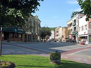
Broadway Street, in Saranac Lake
|
|||
|
|||
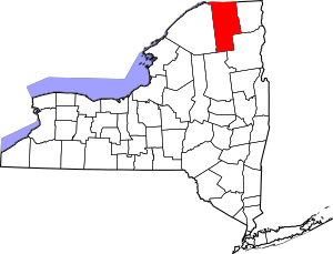
Location within the U.S. state of New York
|
|||
 New York's location within the U.S. |
|||
| Country | |||
| State | |||
| Founded | 1808 | ||
| Named for | Benjamin Franklin | ||
| Seat | Malone | ||
| Largest village | Malone | ||
| Area | |||
| • Total | 1,697 sq mi (4,400 km2) | ||
| • Land | 1,629 sq mi (4,220 km2) | ||
| • Water | 68 sq mi (180 km2) 4.0% | ||
| Population
(2020)
|
|||
| • Total | 47,555 |
||
| • Density | 28/sq mi (11/km2) | ||
| Time zone | UTC−5 (Eastern) | ||
| • Summer (DST) | UTC−4 (EDT) | ||
| Congressional district | 21st | ||
Franklin County is a special area called a county in the northern part of New York State. It shares a border with Canada, right next to the provinces of Quebec and Ontario. In 2020, about 47,555 people lived here.
The main town, or county seat, is Malone. Franklin County is named after Benjamin Franklin, one of the important Founding Fathers of the United States. This county is also part of a larger area in New York called the North Country.
Much of Franklin County is inside the beautiful Adirondack Park. You can also find the St. Regis Mohawk Reservation here. The Mohawk people call this area Akwesasne. People from Akwesasne can cross the border into Canada freely, thanks to the Jay Treaty.
Contents
History of Franklin County
For a very long time, this area was home to Native American groups who spoke Iroquoian languages. One important group was the Mohawks. They had a village south of what is now Montreal, Canada. They traded with French settlers and many became Catholic. The Mohawks were part of a powerful group called the Iroquois League, also known as the Haudenosaunee.
Early Counties and Land Changes
After the English took control of the New York area, they created large counties in 1683. These first counties were huge because not many people lived there yet. Over time, as more settlers arrived, new, smaller counties were formed.
The land that is now Franklin County was first part of Albany County. This county was enormous, stretching all the way to what is now Vermont. Over the years, Albany County was made smaller. New counties like Cumberland County and Gloucester County were created from its land.
In 1772, Albany County was split into three parts. One part kept the name Albany County, and another became Charlotte County. In 1784, Charlotte County was renamed Washington County to honor George Washington, a hero of the American Revolutionary War.
Later, in 1788, Clinton County was created from Washington County. It was much larger than the Clinton County we know today.
Land Sales and New Settlements
After the American Revolutionary War, the United States gained control of lands from the Haudenosaunee (Iroquois Confederacy). New York State then sold off millions of acres of this land cheaply. This was done to encourage people to move there and start farms and businesses. Franklin County was part of a huge land deal called Macomb's Purchase in 1791.
In the late 1700s and early 1800s, Clinton County was made smaller several times. Essex County was split off in 1799. In 1802, St. Lawrence County was formed from parts of Clinton and other counties.
Franklin County is Formed
Finally, in 1808, Franklin County was officially created from Clinton County. It was named after Benjamin Franklin. In the early days, many people living here were farmers who grew just enough food for their families.
Railroads and Industry
In the late 1800s, railroads like the Delaware and Hudson and New York Central came to Franklin County. These trains helped the lumber industry grow. Millions of feet of timber were shipped out from places like Onchiota. Several lumber mills operated here for many years. However, by the early 1900s, most of the trees had been cut down, and the lumber industry slowed.
The railroads also brought summer travelers to Franklin County. In the late 1800s, some of the biggest hotels in the Adirondacks were here, like Paul Smith's Hotel. But as highways were built, people started traveling by car, and passenger train service ended in the mid-1900s.
You can learn more about the history of Franklin County at the Franklin Historical and Museum Society in Malone, New York.
Six Nations Indian Museum
The Six Nations Indian Museum is located in Onchiota. It was founded by Ray Fadden, a Mohawk man, along with his wife and son. The museum has over 3,000 artifacts, mostly from the Iroquoian nations. It helps people understand their culture and history.
Geography
Franklin County covers about 1,697 square miles. Most of this is land (1,629 square miles), and a smaller part is water (68 square miles). It is the fourth-largest county in New York by land area. Franklin County is in the northeastern part of New York State. Its northern edge borders the Canadian provinces of Quebec and Ontario.
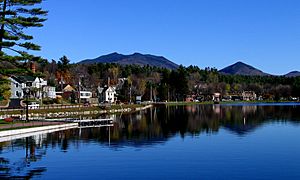
Several beautiful lakes are found here, including Upper, Middle, and Lower Saranac lakes. These lakes are popular natural attractions. Lower Saranac Lake also extends into Essex County. Loon Lake is another lake in the county, with a community named after it.
Neighboring Areas
Franklin County shares borders with these places:
- Clinton County - to the east
- Essex County - to the southeast
- Hamilton County - to the southwest
- St. Lawrence County - to the west
- Stormont, Dundas and Glengarry United Counties, Ontario, Canada - to the northwest
- Le Haut-Saint-Laurent Regional County Municipality, Quebec, Canada - to the north
Population Information
| Historical population | |||
|---|---|---|---|
| Census | Pop. | %± | |
| 1810 | 2,617 | — | |
| 1820 | 4,439 | 69.6% | |
| 1830 | 11,312 | 154.8% | |
| 1840 | 16,518 | 46.0% | |
| 1850 | 25,102 | 52.0% | |
| 1860 | 30,837 | 22.8% | |
| 1870 | 30,271 | −1.8% | |
| 1880 | 32,390 | 7.0% | |
| 1890 | 38,110 | 17.7% | |
| 1900 | 42,853 | 12.4% | |
| 1910 | 45,717 | 6.7% | |
| 1920 | 43,541 | −4.8% | |
| 1930 | 45,694 | 4.9% | |
| 1940 | 44,286 | −3.1% | |
| 1950 | 44,830 | 1.2% | |
| 1960 | 44,742 | −0.2% | |
| 1970 | 43,931 | −1.8% | |
| 1980 | 44,929 | 2.3% | |
| 1990 | 46,540 | 3.6% | |
| 2000 | 51,134 | 9.9% | |
| 2010 | 51,599 | 0.9% | |
| 2020 | 47,555 | −7.8% | |
| U.S. Decennial Census 1790-1960 1900-1990 1990-2000 2010-2020 |
|||
2020 Census Details
The 2020 census showed the different groups of people living in Franklin County:
| Race | Number of People | Percentage |
|---|---|---|
| White | 38,559 | 81.1% |
| Black or African American | 1,686 | 3.54% |
| Native American | 4,102 | 8.63% |
| Asian | 191 | 0.4% |
| Pacific Islander | 0 | 0% |
| Other/Mixed | 1,630 | 3.41% |
| Hispanic or Latino | 1,387 | 2.92% |
Education
Franklin County has many school districts for students from kindergarten to 12th grade:
- AuSable Valley Central School District
- Brasher Falls Central School District
- Brushton-Moira Central School District
- Chateaugay Central School District
- Malone Central School District
- Northern Adirondack Central School District
- Salmon River Central School District
- Saranac Lake Central School District
- St. Regis Falls Central School District
- Tupper Lake Central School District
The county is also home to two colleges: North Country Community College and Paul Smith's College. North Country Community College has campuses in Saranac Lake, Malone, and Ticonderoga.
Transportation
Franklin County does not have public transportation like buses or subways. However, there are many roads that go through the county. Train service for passengers ended in the mid-1900s. The last passenger train from Lake Placid through Lake Clear to Utica ran in 1965.
Airports
There are two public airports in Franklin County:
- Adirondack Regional Airport (SLK) – near Saranac Lake
- Malone-Dufort Airport (MAL) – near Malone
Communities
Franklin County has several towns, villages, and other communities.
Larger Settlements
These are some of the bigger communities in Franklin County:
| # | Location | Population | Type | Area |
|---|---|---|---|---|
| 1 | ‡Akwesasne | About 12,000 | CDP/Territory | Northwest |
| 2 | †Malone | 5,911 | Village | North |
| 3 | ‡Saranac Lake | 5,406 | Village | Adirondack Park |
| 4 | Tupper Lake | 3,667 | Village | Adirondack Park |
| 5 | Fort Covington | 1,308 | CDP | Northwest |
| 6 | Chateaugay | 833 | Village | North |
| 7 | Paul Smiths | 671 | CDP | Adirondack Park |
| 8 | Brushton | 474 | Village | North |
| 9 | St. Regis Falls | 464 | CDP | Adirondack Park |
| 10 | Burke | 211 | Village | North |
† - County Seat (the main town for county government)
‡ - Not Wholly in this County (part of the community is in another county)
Towns
Hamlets
- Gabriels
- Goldsmith
- Hogansburg
- Keese Mill
- Lake Clear
- Owls Head
- Reynoldston
- Saint Regis
- Skerry
- Upper St. Regis
- Vermontville
Native Reservations
- The St. Regis Mohawk Reservation (also known as Akwesasne) is a special area for the Mohawk people. It crosses the border into Quebec, Canada. The community was started in the mid-1700s. People from Akwesasne have the right to travel freely across the border.
Notable Person
- Fernando C. Beaman was a US Congressman from this area.
See also
 In Spanish: Condado de Franklin (Nueva York) para niños
 | DeHart Hubbard |
 | Wilma Rudolph |
 | Jesse Owens |
 | Jackie Joyner-Kersee |
 | Major Taylor |


