
Franklin, Franklin County, New York facts for kids
Quick facts for kids
Franklin, New York
|
|
|---|---|

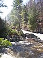
Franklin Falls on the Saranac River in the spring
|
|

Franklin, Franklin County, New York
Location in New York
|
|
| Country | United States |
| State | New York |
| County | Franklin |
| Named for | Benjamin Franklin |
| Government | |
| • Type | Town Council |
| Area | |
| • Total | 175.22 sq mi (453.82 km2) |
| • Land | 169.83 sq mi (439.85 km2) |
| • Water | 5.39 sq mi (13.97 km2) |
| Elevation | 1,693 ft (516 m) |
| Population
(2010)
|
|
| • Total | 1,140 |
| • Estimate
(2016)
|
1,136 |
| • Density | 6.69/sq mi (2.58/km2) |
| Time zone | UTC-5 (Eastern (EST)) |
| • Summer (DST) | UTC-4 (EDT) |
| FIPS code | 36-27243 |
| GNIS feature ID | 0978971 |
Franklin is a town in Franklin County, New York, USA. It is located in the southeastern part of the county. The town is nestled within the beautiful Adirondack Mountains.
As of the 2010 census, about 1,140 people lived in Franklin. The town is named after the famous American inventor and statesman, Benjamin Franklin.
Contents
History of Franklin, New York
Early Settlements and Founding
The first community in Franklin was called Franklin Falls. It was started in 1827. Sadly, this early settlement burned down in 1852.
The town of Franklin was officially created in 1836. It was formed from a part of the nearby town of Bellmont.
Abolitionist Efforts and Civil War Veterans
Franklin played a special role in history. It was used as a place for former slaves to settle. This was partly due to the work of Gerrit Smith, who was an abolitionist. An abolitionist was someone who worked to end slavery.
Also, some Civil War soldiers invited freed slaves to come back home with them to Franklin.
Historic Landmarks
A special building called the Loon Lake Mountain Fire Observation Station is in Franklin. It was added to the National Register of Historic Places in 2008. This means it is an important historical site.
Another historic spot is the Merrillsville Cure Cottage. It was listed on the National Register of Historic Places in 1995.
Geography and Natural Features
Franklin is the third-largest town in Franklin County. It covers a total area of about 175 square miles (453.8 square kilometers). Most of this area is land, with about 5.4 square miles (14.0 square kilometers) being water.
Rivers and Lakes
The Saranac River flows through the southeastern part of the town. This river eventually flows into Lake Champlain.
Franklin is also part of the large Adirondack Park. This park protects a huge area of mountains and forests in New York.
Borders and Nearby Cities
The eastern border of Franklin is shared with Clinton County. The southern border touches Essex County.
New York State Route 3 is a main road that crosses Franklin. It runs from the southwest to the northeast.
- Saranac Lake is about 15 miles (24 km) southwest of Franklin.
- Plattsburgh is about 34 miles (55 km) northeast.
- Malone, which is the main town of Franklin County, is about 34 miles (55 km) to the northwest.
Population and People
| Historical population | |||
|---|---|---|---|
| Census | Pop. | %± | |
| 1840 | 192 | — | |
| 1850 | 724 | 277.1% | |
| 1860 | 1,105 | 52.6% | |
| 1870 | 1,195 | 8.1% | |
| 1880 | 1,184 | −0.9% | |
| 1890 | 1,345 | 13.6% | |
| 1900 | 1,501 | 11.6% | |
| 1910 | 1,447 | −3.6% | |
| 1920 | 1,280 | −11.5% | |
| 1930 | 1,242 | −3.0% | |
| 1940 | 1,002 | −19.3% | |
| 1950 | 872 | −13.0% | |
| 1960 | 695 | −20.3% | |
| 1970 | 550 | −20.9% | |
| 1980 | 926 | 68.4% | |
| 1990 | 1,016 | 9.7% | |
| 2000 | 1,197 | 17.8% | |
| 2010 | 1,140 | −4.8% | |
| 2016 (est.) | 1,136 | −0.4% | |
| U.S. Decennial Census | |||
In 2000, there were 1,197 people living in Franklin. There were 473 households, which are groups of people living together. About 324 of these were families.
The population density was about 7 people per square mile (2.7 people per square kilometer). This means there's a lot of open space in Franklin!
Diversity in Franklin
Most of the people in Franklin were White (97.08%). There were also small percentages of African American, Native American, and Asian residents. Some people identified with two or more races. About 0.42% of the population was Hispanic or Latino.
Households and Families
About 34.5% of households had children under 18 living with them. Most households (57.7%) were married couples. About 26% of all households were made up of people living alone.
The average household had 2.52 people. The average family had 3.04 people.
Age and Income
The median age in Franklin was 40 years old. This means half the people were older than 40 and half were younger.
- 27.2% of the population was under 18.
- 5.4% was between 18 and 24.
- 30.0% was between 25 and 44.
- 24.1% was between 45 and 64.
- 13.2% was 65 or older.
In 2000, the average income for a household in Franklin was $40,598 per year. For families, the average income was $46,250.
Communities and Places in Franklin
Franklin is home to several small communities and interesting locations:
- Alder Brook – A small community in the eastern part of the town.
- Franklin Falls – A community in the southeastern corner. It was once known as "McLenathan Falls."
- Forestdale – Another community in the southeastern corner.
- Goldsmith – A community in the eastern part of the town.
- Hunters Home – A former location in the northeastern part of the town.
- Lake Kushaqua – A small lake near a state campground called Buck Pond.
- Loon Lake – A beautiful lake in the center of the town.
- Loon Lake – A hamlet (small village) located on the eastern side of Loon Lake.
- Merrillsville – A community near the center of Franklin.
- Molasses Corners – A location on the northern side of Loon Lake.
- Onchiota – A community in the southwestern part of the town.
- Rainbow Lake – A lake and community partly in the western side of the town.
- Sugarbush – A community near the eastern town line.
- Two Brooks – A community near the eastern town line.
- Union Falls – A community at the eastern town line, mostly in Clinton County.
- Union Falls Pond – A lake north of Franklin Falls.
- Vermontville – A community and where the town government is located. It was named because many early settlers came from Vermont.
- White Fathers – A former location southwest of Loon Lake, now a ghost town. It was once a seminary (a school for training priests) run by a Catholic missionary group called the White Fathers of Africa.
Images for kids
-
Franklin Falls on the Saranac River in the spring
See also
 In Spanish: Franklin (condado de Franklin, Nueva York) para niños
