Brighton, Franklin County, New York facts for kids
Quick facts for kids
Brighton, New York
|
|
|---|---|
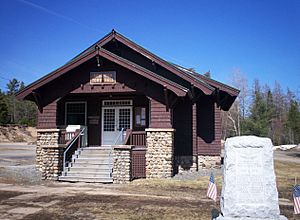
Brighton Town Hall, Benjamin A. Muncil, 1914
|
|
| Country | United States |
| State | New York |
| County | Franklin |
| Named for | Brighton, England |
| Government | |
| • Type | Town Council |
| Area | |
| • Total | 83.00 sq mi (214.96 km2) |
| • Land | 77.90 sq mi (201.75 km2) |
| • Water | 5.10 sq mi (13.21 km2) |
| Elevation | 1,880 ft (573 m) |
| Population
(2010)
|
|
| • Total | 1,435 |
| • Estimate
(2016)
|
1,426 |
| • Density | 18.31/sq mi (7.07/km2) |
| Time zone | UTC-5 (Eastern (EST)) |
| • Summer (DST) | UTC-4 (EDT) |
| FIPS code | 36-08213 |
| GNIS feature ID | 0978752 |
Brighton is a small town located in Franklin County, New York, United States. In 2010, about 1,435 people lived there. The town got its name from Brighton, England, thanks to early mapmakers in the area.
Brighton is in the southern part of Franklin County and is also part of the beautiful Adirondack Park. You can find Paul Smith's College in the community of Paul Smiths, which is a smaller area within Brighton.
Contents
What is the History of Brighton?
How Brighton Became a Town
The Town of Brighton was created in 1858. Before that, it was part of the town of Duane. Settlers living in the southern part of Duane felt left out of town meetings because it was too far to travel. So, they asked for their own town.
James M. Wardner was chosen as Brighton's first leader, called a supervisor.
The Story of Paul Smith's Hotel and College
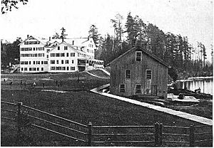
In 1859, a man named Apollos "Paul" Smith arrived in the area. He slowly built a hotel in the community that is now named after him. Paul Smith's Hotel became very famous and was one of the largest hotels around. Important guests like U.S. presidents and governors stayed there.
After Paul Smith passed away in 1912, his son, Phelps Smith, took over the hotel. Sadly, the hotel burned down in 1930. Later, in 1937, Paul Smith's College was started after Phelps Smith died. The college welcomed its first students in 1946. Today, the college is on the land where the famous hotel once stood, right by Lower St. Regis Lake.
Around the same time, James Wardner also had a small hotel on Rainbow Lake.
The Hamlet of Gabriels
The area now known as Gabriels began when early settlers like Alfonzo Rand and William Ricketson cleared the land to start farms. This was in the southern part of Brighton, near a stream called Ricketson Brook.
Gabriels grew bigger when the Adirondack & St. Lawrence Railway arrived in 1892. Many people settled near the train station. After the railroad came, a group of caring women called the Sisters of Mercy opened a special health center for people who were sick in 1897. Paul Smith's Hotel quickly started a stage line (like a bus service) to the train station.
Later, the Sisters of Mercy moved their health center, and it was sold to Paul Smith's College. Even later, it was sold to New York State and became a state facility called Camp Gabriels, which closed in 2009.
Brighton Town Hall
The Brighton Town Hall was designed and built by a talented local builder named Benjamin A. Muncil in 1914. Benjamin Muncil also designed and built other famous places like Marjorie Merriweather Post's Camp Topridge and White Pine Camp. White Pine Camp was even used as a summer home for U.S. President Calvin Coolidge. The Brighton Town Hall was added to the National Register of Historic Places in 2003 because of its historical importance.
Where is Brighton Located?
Brighton is located south of the center of Franklin County. It is entirely within the special protected area known as the Adirondack Forest Preserve, also called the Blue Line.
The town covers about 215 square kilometers (83 square miles). Most of this area is made up of forests, lakes, streams, and ponds. There are also a few small communities and some farmland. Important lakes in the town include Upper and Lower St. Regis Lake in the southwest part of town.
Major Roads in Brighton
New York State Route 30 is a main road that runs north and south through Brighton. It crosses New York State Route 86 in Paul Smiths.
- NY 30 goes north about 32 miles to Malone, which is the main town in Franklin County.
- NY 30 also goes southwest about 26 miles to Tupper Lake.
- NY 86 goes southeast about 12 miles to Saranac Lake.
How Many People Live in Brighton?
| Historical population | |||
|---|---|---|---|
| Census | Pop. | %± | |
| 1860 | 208 | — | |
| 1870 | 204 | −1.9% | |
| 1880 | 267 | 30.9% | |
| 1890 | 480 | 79.8% | |
| 1900 | 706 | 47.1% | |
| 1910 | 741 | 5.0% | |
| 1920 | 684 | −7.7% | |
| 1930 | 993 | 45.2% | |
| 1940 | 804 | −19.0% | |
| 1950 | 962 | 19.7% | |
| 1960 | 1,092 | 13.5% | |
| 1970 | 1,473 | 34.9% | |
| 1980 | 1,625 | 10.3% | |
| 1990 | 1,511 | −7.0% | |
| 2000 | 1,682 | 11.3% | |
| 2010 | 1,435 | −14.7% | |
| 2016 (est.) | 1,426 | −0.6% | |
| U.S. Decennial Census | |||
According to the census in 2000, there were 1,682 people living in Brighton. The population density was about 21.6 people per square mile.
The people living in Brighton were a mix of different ages:
- About 11.7% were under 18 years old.
- About 37.5% were between 18 and 24 years old.
- About 29.8% were between 25 and 44 years old.
- About 15.5% were between 45 and 64 years old.
- About 5.4% were 65 years old or older.
The average age of people in Brighton was 26 years old.
Communities and Lakes in Brighton
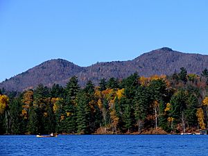
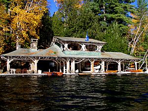
Here are some of the communities and important lakes you can find in Brighton:
- Gabriels – A small community in the southeastern part of town, located on NY-86. It was once the site of a state facility.
- Lower St. Regis Lake – A lake south of Paul Smiths, where Paul Smith's College is located.
- Meacham Lake – A lake partly in the town, located at the northern border.
- Osgood Pond – A lake northeast of Paul Smiths.
- Paul Smiths – A community in the southern part of the town on NY-30.
- Rainbow Lake – This is both a community near the eastern town line and a lake at the eastern town boundary. The lake flows into the North Branch of the Saranac River.
- Spitfire Lake – A lake south of Lower St. Regis Lake.
- Upper St. Regis Lake – A lake located at the southern town line.
See also
 In Spanish: Brighton (condado de Franklin, Nueva York) para niños
 | Madam C. J. Walker |
 | Janet Emerson Bashen |
 | Annie Turnbo Malone |
 | Maggie L. Walker |


