St. Regis Mohawk Reservation facts for kids
| representative democracy | |
 |
|
| Country | St. Regis Reservation |
|---|---|
| Legislative branch | |
| Legislature | Tribal Council |
| Chief | Beverly Kiohawiton Cook (2022) |
| Chief | Michael Karoniatens Conners (2023) |
| Judicial branch | |
| Court | Tribal court, court of appeals, peacemaker court |
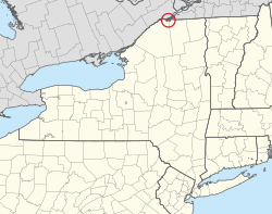
The St. Regis Mohawk Reservation is a special area of land for the Mohawk nation. It is also known by its Mohawk name, Akwesasne. This reservation is located in Franklin County, New York, in the United States.
In 2010, about 3,288 people lived here. The reservation is right next to the Akwesasne reserve in Ontario and Quebec, Canada. The Mohawk people see their entire community as one big family. They have the right to travel freely across the international border between the U.S. and Canada.
Contents
Where is the St. Regis Mohawk Reservation?
The reservation includes the community of St. Regis. It also borders Hogansburg in the town of Bombay. The Mohawk people believe that some lands in the "Bombay Triangle" are part of their reservation. These lands were included in a treaty from 1796.
Thanks to the Jay Treaty of 1794, Mohawk people can cross the Canada–United States border without problems. The reservation is split into two parts by the St. Lawrence River. The border also follows the 45th parallel.
The Mohawk People's Ancient Home
The Mohawk are one of the original Five Nations of the Iroquois League. Historically, they lived south of the Great Lakes in what is now New York and Pennsylvania. They were known as the "Keepers of the Eastern Door." This meant they protected the Iroquois lands from other tribes to the east.
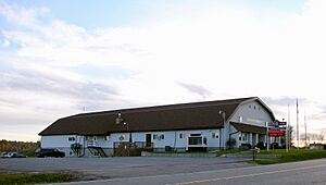
Today, the reservation is home to the Akwesasne Mohawk Casino. Money from the casino helps support the community.
Working Together Across Borders
The elected governments on both the New York and Canadian sides of Akwesasne often work together. They form a "Tri-Council" to handle shared interests. For example, they work together to settle land claims with their national governments.
The Saint Regis Mohawk Tribe sees their reservation as a sovereign nation. This means they have their own government and laws. The U.S. federal government handles certain serious crimes on the reservation. However, the Mohawk also have their own police force for other cases.
Geography of the Reservation
The reservation sits right on the international border between Canada and the United States. It is located along the St. Lawrence River.
The reservation covers about 54.4 square kilometers (21.0 square miles). Most of it is land (49.1 sq km or 19.0 sq mi). About 5.3 sq km (2.0 sq mi), or 9.76%, is water.
It shares borders with several New York towns:
- Fort Covington to the east
- Bombay to the south
- Brasher to the southwest
- Massena to the west
To the north, it borders the Akwesasne reserve in Quebec and Ontario, Canada. The closest city is Cornwall, Ontario, which is about 6 miles (10 km) northwest.
In August 2021, the St. Regis Mohawk Reservation bought an additional 41.5 acres in Franklin County, New York.
History of the Akwesasne Community
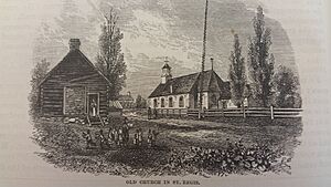
The original settlement was called Akwesasne. French missionaries later named it Saint Régis. This name honored Jean François Régis, a Catholic saint who wanted to be a missionary to the Iroquois.
The community was founded around 1755. Several Catholic Iroquois families, mostly Mohawk, moved there. They came from the mission village of Caughnawaga, Quebec. They were looking for a better life and wanted to avoid problems with traders. Jesuit missionaries also came with them.
Border Changes and Their Impact
After the U.S. and Canada set their border, things became more complicated. But the 1795 Jay Treaty allowed the Mohawk to cross the border freely. Over time, the Mohawk on both sides of the St. Lawrence River lost land. Large construction projects also affected them. These projects included building the St. Lawrence Seaway, the Three Nations Crossing bridge, and dams for electricity.
Restoring the St. Regis River
Since 1762, mills and dams were built on the St. Regis River. One dam, built in 1929, was 11 feet high. It stopped salmon from swimming upriver from the St. Lawrence. This meant the people on the reservation lost an important food source. It also harmed salmon and other fish populations.
By 2010, the dam was too old and expensive to fix. The owner gave up its license. The Saint Regis Mohawk Tribal government decided to take over and remove the dam. They successfully removed it in 2016.
Now, 275 miles of the St. Regis River are open again for fish. People hope that salmon and other fish, like walleye, will return quickly.
Healing the Land and Culture
In 2013, the tribe received $19 million. This money came from companies like "GM, Alcoa, and Reynolds." It was a settlement for pollution in their fishing and hunting areas along the St. Lawrence River. The companies are also cleaning up the pollution.
The tribe plans to use this money to rebuild the area where the dam used to be. They want it to be a place for cultural restoration. Older tribal members will teach younger ones the Mohawk language. They will also share traditional skills like fishing, hunting, basket weaving, gardening, and medicine.
Community Life and Population
The population of the St. Regis Mohawk Reservation has grown over the years.
| Historical population | |||
|---|---|---|---|
| Census | Pop. | %± | |
| 1900 | 1,253 | — | |
| 1910 | 1,249 | −0.3% | |
| 1920 | 1,016 | −18.7% | |
| 1930 | 945 | −7.0% | |
| 1940 | 1,262 | 33.5% | |
| 1950 | 1,409 | 11.6% | |
| 1960 | 1,774 | 25.9% | |
| 1970 | 1,536 | −13.4% | |
| 1980 | 1,802 | 17.3% | |
| 1990 | 1,978 | 9.8% | |
| 2000 | 2,699 | 36.5% | |
| 2010 | 3,228 | 19.6% | |
| 2014 (est.) | 3,248 | 0.6% | |
| U.S. Decennial Census | |||
In 2000, there were 2,699 people living on the U.S. side of the reservation. Most residents (97.41%) were Native American.
The community has many families. About 44.8% of households had children under 18. The average household had almost 3 people. The average family had over 3 people.
The population is quite young. About 34.1% of residents were under 18. The median age was 30 years old.
Education for Mohawk Children
The Salmon River Central School District serves the entire St. Regis Mohawk Reservation. There is one school located directly on the reservation:
- St. Regis Mohawk School: This school teaches students from Pre-Kindergarten to 6th grade. The State of New York owns the school building and handles repairs. The school district provides teachers and manages the school's daily operations.
After elementary school, students attend Salmon River Middle School and Salmon River High School.
Images for kids
 | Precious Adams |
 | Lauren Anderson |
 | Janet Collins |


