Malone (village), New York facts for kids
Quick facts for kids
Malone, New York
|
|
|---|---|
|
Village
|
|
 |
|
| Nickname(s):
The Star of the North
|
|
| Country | United States |
| State | New York |
| County | Franklin |
| Town | Malone |
| Area | |
| • Total | 3.19 sq mi (8.25 km2) |
| • Land | 3.12 sq mi (8.08 km2) |
| • Water | 0.07 sq mi (0.17 km2) |
| Elevation | 712 ft (217 m) |
| Population
(2020)
|
|
| • Total | 5,483 |
| • Density | 1,757.94/sq mi (678.68/km2) |
| Time zone | UTC-5 (Eastern (EST)) |
| • Summer (DST) | UTC-4 (EDT) |
| ZIP code |
12953
|
| Area code(s) | 518 |
| FIPS code | 36-44710 |
| GNIS feature ID | 0956316 |
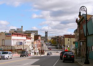
Malone is a small village located in Franklin County, New York, in the United States. It is the main town, also known as the county seat, of Franklin County. In 2010, about 5,911 people lived there. Malone is part of the larger town of Malone. It is also home to a part of North Country Community College.
Contents
History of Malone
Early Settlement and Conflicts
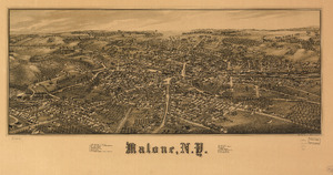
People first started settling in the Malone area around 1802. During the War of 1812, which was a conflict between the United States and Great Britain, British soldiers attacked and damaged the village. They came from what is now Canada.
Malone officially became a village in 1853. Later, in 1866 and 1870, it was a starting point for groups called the Fenians. These groups tried to invade Canada from different spots along the Canada–United States border. The Fenian Brotherhood wanted to take over Canada to help end British rule in Ireland.
Famous Connections and Historic Sites
The famous author Laura Ingalls Wilder wrote a book called Farmer Boy. This book is about the childhood of her husband, Almanzo Wilder, who went to Franklin Academy in Malone. Today, this school building is where Malone Middle School is located.
The Wilder Homestead, Almanzo's childhood home, is a historical site. It is about 5 miles (8 km) east of Malone village in the town of Burke. The First Congregational Church was the first Christian church built in Franklin County. It is believed to be the church mentioned in Farmer Boy.
There is also a story that the second church building (used from 1852 to 1883) was a secret stop on the Underground Railroad. This was a network of safe houses that helped enslaved people escape to freedom. A hidden tunnel, possibly used by those seeking freedom, can still be found in the church's basement.
Recent Events and Landmarks
In 1998, Malone experienced a big natural disaster called the North American Ice Storm of 1998. This storm caused widespread power outages and damage due to thick ice.
In 2012, people in Malone voted on whether to combine their village with the larger town of Malone. However, the proposal was defeated, and the village remained separate.
Several other important buildings in Malone are listed on the National Register of Historic Places. These include the Horton Gristmill, Anselm Lincoln House, Malone Armory, Malone Freight Depot, Paddock Building, and the United States Post Office.
Economy of Malone
Local Industries
Malone is mainly a farming community. Many dairy farms and potato growers are found around the village. In the past, Malone was also known for growing hops, which are used to make beer.
The New York Central and Rutland Railroads used to have large train yards here for switching and maintaining trains.
Malone has also been home to factories that made different products. These included Sno-Pruf, a waterproofer for boots, woolen winter clothes from Ballard Mill, and Sioux-Mocs slippers. Malone even became known as the snowmobile capital of the United States for a while. This happened when a local farm equipment store became the main seller for Bombardier Recreational Products east of the Mississippi River.
Several prisons have been built near Malone. These prisons have become important places for people to work in the area.
Tourism and Recreation
Tourism is a big part of Malone's economy. Titus Mountain, located about 6 miles (10 km) south of the village, attracts skiers in the winter. The Malone Golf Club, which has 36 holes designed by Robert Trent Jones, brings golfers from places like Montreal, Quebec.
Geography of Malone
Malone village is located in the northern part of the town of Malone. Its exact location is 44°51′2″N 74°17′20″W / 44.85056°N 74.28889°W.
The United States Census Bureau says that the village covers a total area of about 3.19 square miles (8.23 square kilometers). Most of this area, about 3.12 square miles (8.06 square kilometers), is land. The rest, about 0.07 square miles (0.17 square kilometers), is water.
Transportation Routes
Malone is a meeting point for several important roads. These include U.S. Route 11, New York State Route 11B (NY 11B), NY 30, and NY 37. County Road 25 also enters the village from the south.
- US-11 goes east for about 46 miles (74 km) to Champlain and southwest for about 37 miles (60 km) to Potsdam.
- NY-30 goes south for about 58 miles (93 km) to Tupper Lake in the Adirondacks. It goes north for about 11 miles (18 km) to Trout River at the border with Canada.
- Cornwall, Ontario, in Canada, is about 31 miles (50 km) to the northwest if you take NY-37.
The Salmon River flows north through the village. This river eventually flows into the St. Lawrence River.
Climate in Malone
Malone has a hemiboreal climate, which means it has cold, snowy winters and warm summers. This type of climate is also known as "Dfb" in the Köppen climate classification system.
| Climate data for Malone, NY | |||||||||||||
|---|---|---|---|---|---|---|---|---|---|---|---|---|---|
| Month | Jan | Feb | Mar | Apr | May | Jun | Jul | Aug | Sep | Oct | Nov | Dec | Year |
| Mean daily maximum °F (°C) | 23 (−5) |
26 (−3) |
35 (2) |
49 (9) |
64 (18) |
72 (22) |
76 (24) |
74 (23) |
66 (19) |
54 (12) |
41 (5) |
29 (−2) |
51 (10) |
| Mean daily minimum °F (°C) | 4 (−16) |
7 (−14) |
18 (−8) |
31 (−1) |
44 (7) |
53 (12) |
57 (14) |
55 (13) |
47 (8) |
36 (2) |
27 (−3) |
13 (−11) |
33 (0) |
| Average precipitation inches (mm) | 2.36 (60) |
2.00 (51) |
2.24 (57) |
2.74 (70) |
2.92 (74) |
3.87 (98) |
4.19 (106) |
4.63 (118) |
3.65 (93) |
3.27 (83) |
3.41 (87) |
2.53 (64) |
37.81 (961) |
| Source: The Weather Channel | |||||||||||||
Demographics of Malone
Population Changes Over Time
The population of Malone has changed over many years. Here is a look at how many people have lived in the village during different census years:
| Historical population | |||
|---|---|---|---|
| Census | Pop. | %± | |
| 1880 | 4,193 | — | |
| 1890 | 4,986 | 18.9% | |
| 1900 | 5,935 | 19.0% | |
| 1910 | 6,467 | 9.0% | |
| 1920 | 7,556 | 16.8% | |
| 1930 | 8,657 | 14.6% | |
| 1940 | 8,743 | 1.0% | |
| 1950 | 9,501 | 8.7% | |
| 1960 | 8,737 | −8.0% | |
| 1970 | 8,048 | −7.9% | |
| 1980 | 7,668 | −4.7% | |
| 1990 | 6,777 | −11.6% | |
| 2000 | 6,075 | −10.4% | |
| 2010 | 5,911 | −2.7% | |
| 2020 | 5,483 | −7.2% | |
| U.S. Decennial Census | |||
As of the 2000 census, there were 6,075 people living in Malone. These people lived in 2,583 households, and 1,511 of these were families. The average number of people in a household was 2.24, and the average family size was 2.86.
Age Distribution
The population in Malone is spread out across different age groups. In 2000:
- About 23.0% of the people were under 18 years old.
- About 7.6% were between 18 and 24 years old.
- About 26.1% were between 25 and 44 years old.
- About 22.9% were between 45 and 64 years old.
- About 20.4% were 65 years old or older.
The average age of people in Malone was 40 years old.
Education in Malone
The schools in Malone are part of the Malone Central School District.
See also
 In Spanish: Malone (villa) para niños
 | John T. Biggers |
 | Thomas Blackshear |
 | Mark Bradford |
 | Beverly Buchanan |


