Santa Clara, New York facts for kids
Quick facts for kids
Santa Clara, New York
|
|
|---|---|

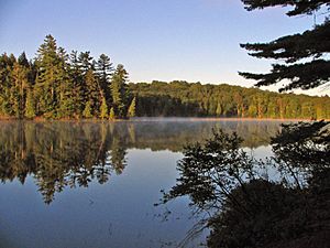
Long Pond in the Saint Regis Canoe Area
|
|
| Country | United States |
| State | New York |
| County | Franklin |
| Government | |
| • Type | Town Council |
| Area | |
| • Total | 191.71 sq mi (496.53 km2) |
| • Land | 174.42 sq mi (451.75 km2) |
| • Water | 17.29 sq mi (44.79 km2) |
| Elevation | 1,588 ft (484 m) |
| Population
(2010)
|
|
| • Total | 345 |
| • Estimate
(2016)
|
341 |
| • Density | 1.96/sq mi (0.75/km2) |
| Time zone | UTC-5 (Eastern (EST)) |
| • Summer (DST) | UTC-4 (EDT) |
| ZIP code |
12980
|
| Area code(s) | 518 |
| FIPS code | 36-033-65178 |
| GNIS feature ID | 0979459 |
Santa Clara is a small town located in Franklin County, New York, United States. In 2020, about 332 people lived there. This was a slight decrease from 345 people in 2010. The town got its name from the wife of an important early businessman, John Hurd.
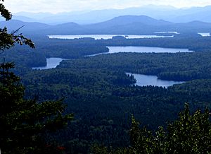
The town is in the southwestern part of Franklin County. It is southwest of the village of Malone and west of the village of Saranac Lake. Santa Clara is part of the beautiful Adirondack Park. It is home to the 58 ponds of the Saint Regis Canoe Area. This area is special because it's the only Canoe Wilderness Area in the park. Most of the 4,700-acre (19 km2) Upper Saranac Lake is also found here.
Contents
Exploring Santa Clara's Past
The town of Santa Clara was created in 1888. It was formed from a part of the nearby town of Brandon. Later, in 1896, more land from Brandon was added to Santa Clara.
Around 1896, a wealthy businessman named William Rockefeller started buying land in the town. He wanted to build a large summer home for his family to enjoy.
A special building called the St. Regis Mountain Fire Observation Station was added to the National Register of Historic Places in 2005. This means it's an important historical site.
Discovering Santa Clara's Geography
Santa Clara covers a total area of about 191.7 square miles (496.5 km2). Most of this area, about 174.4 square miles (451.7 km2), is land. The rest, about 17.3 square miles (44.8 km2), is water.
Santa Clara is the second largest town in Franklin County. The southern part of the town has many lakes.
Two main roads cross through Santa Clara. New York State Route 458 runs north and south. New York State Route 30 goes through the southern part of the town.
The St. Regis River flows out of the western side of the town. This river flows north and eventually joins the St. Lawrence River.
People and Population in Santa Clara
| Historical population | |||
|---|---|---|---|
| Census | Pop. | %± | |
| 1890 | 1,690 | — | |
| 1900 | 580 | −65.7% | |
| 1910 | 675 | 16.4% | |
| 1920 | 541 | −19.9% | |
| 1930 | 528 | −2.4% | |
| 1940 | 258 | −51.1% | |
| 1950 | 251 | −2.7% | |
| 1960 | 158 | −37.1% | |
| 1970 | 168 | 6.3% | |
| 1980 | 310 | 84.5% | |
| 1990 | 311 | 0.3% | |
| 2000 | 395 | 27.0% | |
| 2010 | 345 | −12.7% | |
| 2016 (est.) | 341 | −1.2% | |
| U.S. Decennial Census | |||
In the year 2000, there were 395 people living in Santa Clara. These people lived in 155 households, and 119 of these were families. The population density was about 2.3 people per square mile (0.9 people per km2).
About 31.6% of the households had children under 18 years old. Most households (63.2%) were married couples living together. The average household had about 2.55 people.
The population was spread out by age. About 25.1% were under 18 years old. About 15.9% were 65 years or older. The average age in the town was 43 years.
Communities and Places in Santa Clara

- Bay Pond – This is a small community in the south-central part of town. It used to be a summer home for the Rockefeller family.
- Brandon – This was once a community north of Bay Pond. Its buildings were removed when it became part of the Rockefeller estate.
- Derrick – A small community located west of Saranac Inn.
- Everton – This community was abandoned after the forests nearby were cut down.
- Floodwood – A community found west of Saranac Inn, close to the western town border.
- Kildare – Another community west of Saranac Inn, near the western town boundary.
- Madawaska – A small community near the eastern town line.
- Madawaska Pond – A lake located near the center of the town.
- Middle Saranac Lake – A part of this lake is in the southeastern corner of the town.
- Meno – A place located northeast of Madawaska.
- The Saint Regis Canoe Area – This is a large wilderness area, about 19,000 acres (77 km2). It has 58 ponds and does not allow motorized vehicles.
- Santa Clara – The main community of Santa Clara is near the western town line in the northern part of the town, along NY-458.
- Saranac Inn (also called "Upper Saranac") – A community in the southern part of the town.
- Saranac Inn Station – A location east of Saranac Inn.
- Spring Cove – A community near the western town boundary, south of Santa Clara village.
- Upper Saranac Lake – Most of this large lake is in the southern part of the town.
- Weller Pond – A big pond located in the southern part of the town.
See also
 In Spanish: Santa Clara (Nueva York) para niños
 | Percy Lavon Julian |
 | Katherine Johnson |
 | George Washington Carver |
 | Annie Easley |


