Mooers, New York facts for kids
Quick facts for kids
Mooers, New York
|
|
|---|---|
 |
|

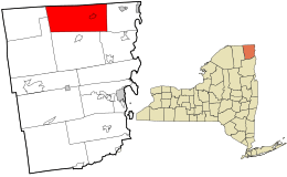
Location in Clinton County and the state of New York.
|
|
| Country | United States |
| State | New York |
| County | Clinton |
| Government | |
| • Type | Town Council |
| Area | |
| • Total | 87.92 sq mi (227.72 km2) |
| • Land | 87.58 sq mi (226.84 km2) |
| • Water | 0.34 sq mi (0.88 km2) |
| Elevation | 280 ft (90 m) |
| Population
(2010)
|
|
| • Total | 3,592 |
| • Estimate
(2016)
|
3,591 |
| • Density | 41.00/sq mi (15.83/km2) |
| Time zone | Eastern (EST) |
| ZIP code |
12958
|
| Area code(s) | 518 |
| FIPS code | 36-019-48252 |
Mooers is a small town located in Clinton County, in the state of New York, United States. In 2010, about 3,592 people lived there. The town gets its name from Benjamin Mooers, who was one of the first people to settle in the area.
Mooers is found along the northern edge of Clinton County. It is located to the northwest of the city of Plattsburgh.
Contents
A Look Back: Mooers' History
The area where Mooers is now was first settled around 1796. The town of Mooers was officially created in 1804. It was formed from a part of the nearby town of Champlain. Later, in 1830, another part of Mooers was used to create a new town called Ellenburg.
Geography of Mooers
Mooers covers a total area of about 227.7 square kilometers (87.9 square miles). Most of this area, about 227.0 square kilometers (87.6 square miles), is land. Only a small part, about 0.8 square kilometers (0.3 square miles), is water.
The northern border of Mooers is also the border between Canada and the United States, specifically with the province of Quebec. The Great Chazy River flows through the town, moving from west to east.
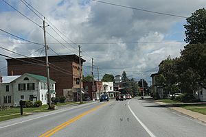
U.S. Route 11 is a main road that goes through Mooers from east to west. In the village of Mooers, this route meets the northern end of New York State Route 22.
People of Mooers
The population of Mooers has changed over the years. Here's how it has grown or shrunk:
| Historical population | |||
|---|---|---|---|
| Census | Pop. | %± | |
| 1820 | 567 | — | |
| 1830 | 1,222 | 115.5% | |
| 1840 | 1,703 | 39.4% | |
| 1850 | 3,365 | 97.6% | |
| 1860 | 3,926 | 16.7% | |
| 1870 | 4,634 | 18.0% | |
| 1880 | 4,381 | −5.5% | |
| 1890 | 3,467 | −20.9% | |
| 1900 | 3,572 | 3.0% | |
| 1910 | 3,163 | −11.5% | |
| 1920 | 2,788 | −11.9% | |
| 1930 | 2,655 | −4.8% | |
| 1940 | 2,686 | 1.2% | |
| 1950 | 2,509 | −6.6% | |
| 1960 | 2,587 | 3.1% | |
| 1970 | 2,606 | 0.7% | |
| 1980 | 2,927 | 12.3% | |
| 1990 | 2,995 | 2.3% | |
| 2000 | 3,398 | 13.5% | |
| 2010 | 3,592 | 5.7% | |
| 2016 (est.) | 3,591 | 0.0% | |
| U.S. Decennial Census | |||
According to the census from 2000, there were 3,404 people living in Mooers. These people made up 1,264 households and 942 families. The town had about 38.8 people per square mile.
About 36.9% of the households had children under 18 living with them. Most households (60.0%) were married couples living together. The average household had 2.69 people, and the average family had 3.08 people.
The median age in the town was 36 years old. About 26.8% of the population was under 18. For every 100 females, there were about 103.8 males.
The median income for a household in Mooers was $39,152. For families, the median income was $41,908. About 10.9% of the population lived below the poverty line. This included 11.8% of those under 18 and 11.9% of those 65 or older.
Places in Mooers
Mooers has several smaller communities and locations within its borders:
- Angellville – This was a community that used to be in the southeastern part of Mooers.
- Cannon Corners – A small village, also known as a hamlet, in the western part of the town. It is located between Mooers Forks and the Canada–US border.
- English River – A small stream that flows through the western part of the town.
- Mooers – This is the main village of Mooers. It's in the eastern part of the town where US-11 and NY-22 meet near the Chazy River. It was once called "Mooers-upon-the-Chazy."
- Mooers Forks (formerly "Centerville") – Another hamlet located near the center of the town, also on US-11.
- Twin Bridges – A hamlet found on the eastern border of the town, along US-11.
- Whitney Corners – A hamlet located to the west of Mooers Forks.
- Woods Falls – A hamlet in the southern part of the town, south of Mooers Forks.
See also
 In Spanish: Mooers (Nueva York) para niños
 | Janet Taylor Pickett |
 | Synthia Saint James |
 | Howardena Pindell |
 | Faith Ringgold |

