
Grand Isle County, Vermont facts for kids
Quick facts for kids
Grand Isle County
|
|
|---|---|

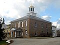
Grand Isle County Courthouse in North Hero
|
|

Location within the U.S. state of Vermont
|
|
 Vermont's location within the U.S. |
|
| Country | |
| State | |
| Founded | 1805 |
| Shire Town | North Hero |
| Largest town | Alburgh (town) |
| Area | |
| • Total | 195 sq mi (510 km2) |
| • Land | 82 sq mi (210 km2) |
| • Water | 113 sq mi (290 km2) 58% |
| Population
(2020)
|
|
| • Total | 7,293 |
| • Density | 37.40/sq mi (14.44/km2) |
| Time zone | UTC−5 (Eastern) |
| • Summer (DST) | UTC−4 (EDT) |
| Congressional district | At-large |
Grand Isle County is a county in the state of Vermont, USA. In 2020, about 7,293 people lived here. This makes it Vermont's second-smallest county by population. The main town, or shire town, is North Hero. The county was officially formed in 1805.
Grand Isle County is part of the Burlington area. There isn't a high school in the county. Students go to high schools in nearby counties. The county is made up of several islands and peninsulas in Lake Champlain. These are connected by U.S. Route 2.
Contents
History of Grand Isle County
Grand Isle County is one of several counties in Vermont that used to be part of New York. Vermont declared itself a separate state on January 15, 1777. This meant it took land from New York.
Many states like Massachusetts, New Hampshire, and even New France and New Netherland once claimed this land. But in 1764, King George III set the border between New Hampshire and New York. This border was along the Connecticut River.
New York then added this land to its Albany County. Later, in 1772, Albany County was split to create Charlotte County. This situation continued until Vermont became independent.
The Revolutionary War ended in 1783 with the Treaty of Paris. Great Britain recognized the United States as independent. Vermont's border with Quebec (in Canada) was set at the 45 degrees north latitude. This is why Grand Isle County doesn't connect to the rest of the U.S. by land.
Massachusetts gave up its claim to the region in 1786. New York was still unhappy about losing the land. So, it asked the U.S. Congress to decide the issue. Congress sided with Vermont in 1788.
When Vermont wanted to become a state, Congress asked New York and Vermont to agree on their border. They did, and Vermont became a state on March 4, 1791. Grand Isle County was created in 1802. It was formed from parts of Franklin and Chittenden Counties.
In the late 1800s, the Rutland Railroad ran trains through the area. From 1899, causeways (raised roads over water) allowed trains to travel through the Lake Champlain islands. This connected them directly to Burlington. The last train service from Alburgh was in 1948.
Geography of Grand Isle County
Grand Isle County covers about 195 square miles. About 82 square miles are land, and 113 square miles (58%) are water. It has the most water coverage of any county in Vermont. It is also the smallest county in Vermont by land area. Only Essex County has fewer people.
Four of its five towns are on islands in Lake Champlain. These are North Hero, South Hero, Grand Isle, and Isle La Motte. The town of Alburgh is on a peninsula. This peninsula extends south into the lake from Quebec, Canada. It's like a piece of land that is separated from the main country.
The highest point in the county is only 279 feet high. This is on the west side of South Hero. The lake's edge is usually about 99 feet above sea level.
There are three main islands where people live, one inhabited peninsula, and many smaller islands without people. Alburgh is the largest land area in Grand Isle County. It borders Quebec to the north. Isle La Motte, North Hero Island, and Grand Island are the three inhabited islands.
Grand Isle County does not share any land borders with the rest of the United States. However, there are three bridges that connect it to the mainland. Two bridges connect to Vermont, and one connects to New York State.
Neighboring Counties
- Franklin County – to the east
- Chittenden County – to the southeast
- Clinton County, New York – to the west
- Le Haut-Richelieu Regional County Municipality, Quebec – to the north (in Canada)
Main Roads
 US 2
US 2 VT 78
VT 78
 VT 129
 VT 225
Population of Grand Isle County
| Historical population | |||
|---|---|---|---|
| Census | Pop. | %± | |
| 1810 | 3,445 | — | |
| 1820 | 3,527 | 2.4% | |
| 1830 | 3,696 | 4.8% | |
| 1840 | 3,883 | 5.1% | |
| 1850 | 4,145 | 6.7% | |
| 1860 | 4,276 | 3.2% | |
| 1870 | 4,082 | −4.5% | |
| 1880 | 4,124 | 1.0% | |
| 1890 | 3,843 | −6.8% | |
| 1900 | 4,462 | 16.1% | |
| 1910 | 3,761 | −15.7% | |
| 1920 | 3,784 | 0.6% | |
| 1930 | 3,944 | 4.2% | |
| 1940 | 3,802 | −3.6% | |
| 1950 | 3,406 | −10.4% | |
| 1960 | 2,927 | −14.1% | |
| 1970 | 3,574 | 22.1% | |
| 1980 | 4,613 | 29.1% | |
| 1990 | 5,318 | 15.3% | |
| 2000 | 6,901 | 29.8% | |
| 2010 | 6,970 | 1.0% | |
| 2020 | 7,293 | 4.6% | |
| U.S. Decennial Census 1790–1960 1900–1990 1990–2000 2010–2018 |
|||
In 2010, there were 6,970 people living in Grand Isle County. There were 2,902 households and 2,027 families. The population density was about 85 people per square mile.
Most people (95.3%) were white. About 0.9% were American Indian, and 0.4% were Black or African American. About 1.1% of the population was of Hispanic or Latino background.
Many people had roots from different countries. For example, 18.0% had English ancestry. Others had Irish (14.2%), French Canadian (10.6%), or German (10.3%) ancestry.
The average age in the county was 45.5 years old. The average income for a household was $57,436. For a family, it was $66,686. About 6.4% of the population lived below the poverty line. This included 9.9% of those under 18.
Towns and Villages
Towns
- Alburgh
- Grand Isle
- Isle La Motte
- North Hero (the main town)
- South Hero
Village
Census-designated place
- South Hero
Notable Person
- Bernie Sanders: He was the mayor of Burlington from 1981 to 1989. He has been a U.S. Senator for Vermont since 2007. He also ran for president in 2016 and 2020.
Images for kids
-
Grand Isle County Courthouse in North Hero
See also
 In Spanish: Condado de Grand Isle para niños
