Franklin County, Vermont facts for kids
Quick facts for kids
Franklin County
|
|
|---|---|

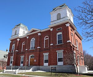
Franklin County Court House in St. Albans
|
|

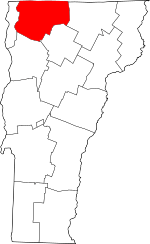
Location within the U.S. state of Vermont
|
|
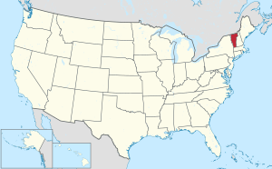
 Vermont's location within the U.S. |
|
| Country | |
| State | |
| Founded | December 1, 1796 |
| Named for | Benjamin Franklin |
| Shire Town | St. Albans |
| Largest city | St. Albans |
| Area | |
| • Total | 692 sq mi (1,790 km2) |
| • Land | 634 sq mi (1,640 km2) |
| • Water | 58 sq mi (150 km2) 8.4%% |
| Population
(2020)
|
|
| • Total | 49,946 |
| • Density | 72.18/sq mi (27.867/km2) |
| Time zone | UTC−5 (Eastern) |
| • Summer (DST) | UTC−4 (EDT) |
| Congressional district | At-large |
Franklin County is a county in the state of Vermont. A county is like a large district within a state. In 2020, about 49,946 people lived here. The main city and county seat (where the county government is) is St. Albans.
Franklin County is special because it shares a border with the Canadian province of Quebec. It was officially created in 1792 and started working as a county in 1796. This county is also part of the larger Burlington metropolitan area, which means it's connected to a bigger group of cities and towns.
Contents
History of Franklin County
Franklin County is one of many counties in Vermont that were formed from land claimed by Vermont. This happened on January 15, 1777, when Vermont decided it was a state separate from New York. Before this, different states like Massachusetts, New Hampshire, and New York all claimed this land.
In 1764, King George III set a boundary between New Hampshire and New York. This line helped define where Vermont's land was. Later, in 1772, surveyors John Collins and Thomas Valentine marked a line that was supposed to be the border between New York and Quebec. Even though their measurements weren't perfect, that line is still the border between Vermont and Quebec today! It's called the Collins–Valentine line.
The Treaty of Paris was signed in 1783, ending the Revolutionary War. Great Britain recognized the United States as an independent country. This treaty also set the border between the U.S. and British lands to the north, placing Vermont within the United States.
Franklin County was officially formed in 1792 from a part of Chittenden County. The county is named after Benjamin Franklin, a famous American inventor and statesman.
Did you know that Chester A. Arthur, who was the 21st U.S. President, was born in the town of Fairfield in Franklin County? He was one of only two U.S. Presidents born in Vermont! The other was Calvin Coolidge.
In 2008, the government declared Franklin County a disaster area. This was because of very bad storms and floods that happened in June of that year.
Geography of Franklin County
Franklin County covers about 692 square miles (1,792 square kilometers). Most of this area, about 634 square miles (1,642 square kilometers), is land. The rest, about 58 square miles (150 square kilometers), is water, making up about 8.4% of the county's total area.
Neighboring Areas
Franklin County shares its borders with several other counties and areas:
- Orleans County – to the east
- Lamoille County – to the southeast
- Chittenden County – to the southwest
- Grand Isle County – to the west
- Le Haut-Richelieu Regional County Municipality, Quebec – to the northwest (in Canada)
- Brome-Missisquoi Regional County Municipality, Quebec – to the north (in Canada)
Protected Natural Areas
- Missisquoi National Wildlife Refuge is a special area in the county that protects wildlife and their homes.
Population and People
| Historical population | |||
|---|---|---|---|
| Census | Pop. | %± | |
| 1800 | 8,282 | — | |
| 1810 | 16,615 | 100.6% | |
| 1820 | 17,192 | 3.5% | |
| 1830 | 24,525 | 42.7% | |
| 1840 | 24,531 | 0.0% | |
| 1850 | 28,586 | 16.5% | |
| 1860 | 27,231 | −4.7% | |
| 1870 | 30,291 | 11.2% | |
| 1880 | 30,225 | −0.2% | |
| 1890 | 29,755 | −1.6% | |
| 1900 | 30,198 | 1.5% | |
| 1910 | 29,866 | −1.1% | |
| 1920 | 30,026 | 0.5% | |
| 1930 | 29,975 | −0.2% | |
| 1940 | 29,601 | −1.2% | |
| 1950 | 29,894 | 1.0% | |
| 1960 | 29,474 | −1.4% | |
| 1970 | 31,282 | 6.1% | |
| 1980 | 34,788 | 11.2% | |
| 1990 | 39,980 | 14.9% | |
| 2000 | 45,417 | 13.6% | |
| 2010 | 47,746 | 5.1% | |
| 2020 | 49,946 | 4.6% | |
| U.S. Decennial Census 1790–1960 1900–1990 1990–2000 2010–2018 |
|||
In 2010, there were 47,746 people living in Franklin County. There were 18,513 households, which are groups of people living together. About 34.9% of these households had children under 18 living with them. The average household had about 2.55 people. The average age of people in the county was 39.6 years old.
Economy
Franklin County is known for its agriculture. In 2009, it had the most dairy farms in all of Vermont. There were 239 dairy farms out of 1,078 in the entire state! This shows how important dairy farming is to the county's economy.
Communities in Franklin County
Franklin County has one city, several towns, and some villages and census-designated places.
City
Towns
Villages
Villages are smaller communities within towns. They don't have their own separate governments.
- Enosburg Falls – a village inside Enosburgh
- Swanton Village – a village inside Swanton
Census-designated places
These are areas that the U.S. Census Bureau defines for gathering population data, but they are not officially incorporated as cities or towns.
- Bakersfield
- Fairfax
- Highgate Center
- Highgate Springs
- Richford
See also
 In Spanish: Condado de Franklin (Vermont) para niños
 | Mary Eliza Mahoney |
 | Susie King Taylor |
 | Ida Gray |
 | Eliza Ann Grier |

