
Georgia, Vermont facts for kids
Quick facts for kids
Georgia, Vermont
|
|
|---|---|

District 8 School or "The Brick School" is now the Georgia Historical Society Museum
|
|
| Motto(s):
"Working Together"
|
|

Location in Franklin County and the state of Vermont.
|
|
| Country | United States |
| State | Vermont |
| County | Franklin |
| Communities | Georgia Center Georgia Plains Hubbard Corner Melville Landing Oakland West Georgia |
| Area | |
| • Total | 45.2 sq mi (117.1 km2) |
| • Land | 39.3 sq mi (101.9 km2) |
| • Water | 5.9 sq mi (15.3 km2) |
| Elevation | 364 ft (111 m) |
| Population
(2020)
|
|
| • Total | 4,845 |
| • Density | 123/sq mi (47.5/km2) |
| Time zone | UTC-5 (Eastern (EST)) |
| • Summer (DST) | UTC-4 (EDT) |
| ZIP Codes | |
| Area code(s) | 802 |
| FIPS code | 50-27700 |
| GNIS feature ID | 1462101 |
Georgia is a town located in Franklin County, Vermont, in the United States. In 2020, about 4,845 people lived there. It's a friendly community known for its history and beautiful natural surroundings.
Contents
Where is Georgia, Vermont?
Georgia is in the southwest part of Franklin County. To its south is Chittenden County. The town's western edge touches Lake Champlain and its St. Albans Bay. St. Albans, which is the main city of Franklin County, is to the north.
Major roads like U.S. Route 7 and Interstate 89 go through Georgia. These highways can take you north to St. Albans or south to Burlington.
The town covers about 117.1 square kilometers (45.2 square miles). Most of this is land, but about 15.3 square kilometers (5.9 square miles) is water. The Lamoille River also flows through the southeast part of the town.
A Look at Georgia's History
Georgia was named after King George III. This was done by New Hampshire to try and get the king to side with them in a land argument. Both New York and New Hampshire wanted control over the land that is now Vermont.
During the War of 1812, many people in Vermont were involved in smuggling. Smuggling means secretly bringing goods into or out of a country to avoid taxes or rules. However, the citizens of Georgia were different! They formed a blockade to stop goods from Canada from being smuggled. This blockade was so effective that smugglers started calling Georgia "Hell's Gate." This shows how determined the people of Georgia were to follow the rules.
People of Georgia
| Historical population | |||
|---|---|---|---|
| Census | Pop. | %± | |
| 1790 | 340 | — | |
| 1800 | 1,068 | 214.1% | |
| 1810 | 1,760 | 64.8% | |
| 1820 | 1,703 | −3.2% | |
| 1830 | 1,897 | 11.4% | |
| 1840 | 2,106 | 11.0% | |
| 1850 | 2,686 | 27.5% | |
| 1860 | 1,547 | −42.4% | |
| 1870 | 1,603 | 3.6% | |
| 1880 | 1,504 | −6.2% | |
| 1890 | 1,282 | −14.8% | |
| 1900 | 1,280 | −0.2% | |
| 1910 | 1,090 | −14.8% | |
| 1920 | 1,075 | −1.4% | |
| 1930 | 1,090 | 1.4% | |
| 1940 | 1,008 | −7.5% | |
| 1950 | 1,055 | 4.7% | |
| 1960 | 1,079 | 2.3% | |
| 1970 | 1,711 | 58.6% | |
| 1980 | 2,818 | 64.7% | |
| 1990 | 3,753 | 33.2% | |
| 2000 | 4,375 | 16.6% | |
| 2010 | 4,515 | 3.2% | |
| 2020 | 4,845 | 7.3% | |
| U.S. Decennial Census | |||
In 2000, there were 4,375 people living in Georgia. By 2020, the population had grown to 4,845. Many households in Georgia have children living in them. The average household had about three people. The town's population includes a good mix of ages, with many young people and families. The median age in 2000 was 34 years old.
Famous People from Georgia
Many interesting people have come from Georgia, Vermont:
- J. Allen Barber (1809–1881) was a politician.
- Daniel Bliss (1823–1916) was a missionary who founded the American University of Beirut.
- Jeffrey Brace (1742–1827) was a soldier in the American Revolutionary War and an author.
- Gardner Quincy Colton (1814–1898) was a scientist.
- James M. Hotchkiss (1812–1877) served in the Vermont House of Representatives and Senate.
- Martha Austin Phelps (1870–1933) was a chemist.
- Hester Martha Poole (1833/1834–1932) was a writer, artist, and advocate.
- Alvah Sabin (1793–1885) was a US congressman.
- George J. Stannard (1820–1886) was a farmer, teacher, and Civil War general.
- Armando Vilaseca was a commissioner for the Vermont Department of Education.
- Mehitable E. Woods (1813–1891) was known as a hero during the American Civil War.
Images for kids
-
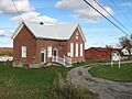
District 8 School or "The Brick School" is now the Georgia Historical Society Museum
-
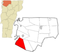
Location in Franklin County and the state of Vermont.
See also
 para niños")
