Swanton (village), Vermont facts for kids
Quick facts for kids
Swanton, Vermont
|
|
|---|---|
|
Village
|
|

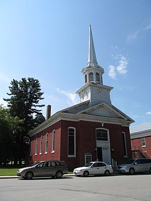
Swanton Christian Church
|
|

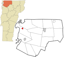
Location in Franklin County and the state of Vermont.
|
|
| Country | United States |
| State | Vermont |
| County | Franklin |
| Town | Swanton |
| Area | |
| • Total | 0.79 sq mi (2.05 km2) |
| • Land | 0.76 sq mi (1.97 km2) |
| • Water | 0.03 sq mi (0.08 km2) |
| Elevation | 148 ft (45 m) |
| Population
(2020)
|
|
| • Total | 2,328 |
| • Density | 2,947/sq mi (1,135.6/km2) |
| Time zone | UTC-5 (Eastern (EST)) |
| • Summer (DST) | UTC-4 (EDT) |
| ZIP code |
05488
|
| Area code(s) | 802 |
| FIPS code | 50-71650 |
| GNIS feature ID | 1459802 |
Swanton is a small village located in Franklin County, Vermont, in the United States. It's often called Swanton Village to help people tell it apart from the larger surrounding area, also named Swanton. In 2020, about 2,328 people lived here. The village was officially started in 1888.
Contents
Where is Swanton Village Located?
Swanton village is found in the middle-north part of the larger town of Swanton. It sits right along the Missisquoi River.
Main Roads and Travel
Several important roads go through Swanton village. U.S. Route 7 runs through the village, known as Grand Avenue, Canada Street, and Spring Street.
- To the north, US 7 goes about 7 miles (11 km) to Interstate 89, which is close to the border with Canada.
- To the south, US 7 travels about 8.5 miles (13.7 km) to St. Albans, which is the main town for Franklin County.
Interstate 89 is just east of Swanton village. You can get on it from Exit 21 (Vermont Route 78).
- I-89 goes north towards the Canada-US border.
- It goes south about 36 miles (58 km) to the Burlington area.
Vermont Route 78 also passes through the village on First Street, Grand Avenue, Depot Street, and North River Street.
- It goes east about 4.5 miles (7.2 km) to Highgate Center.
- It goes west about 10 miles (16 km) to Alburgh on Grand Isle in Lake Champlain.
Vermont Route 36 starts in Swanton village as Lake Street.
- It goes west about 2 miles (3.2 km) to the shore of Lake Champlain at Maquam Bay.
- Then it turns south along the lake for about 8 miles (13 km) to St. Albans Bay.
Size of the Village
The village of Swanton covers a total area of about 0.79 square miles (2.05 square kilometers). Most of this area, about 0.76 square miles (1.97 square kilometers), is land. The rest, about 0.03 square miles (0.08 square kilometers), is water, making up about 4% of the village's total area.
Who Lives in Swanton Village?
| Historical population | |||
|---|---|---|---|
| Census | Pop. | %± | |
| 1880 | 1,200 | — | |
| 1890 | 1,878 | 56.5% | |
| 1900 | 1,168 | −37.8% | |
| 1910 | 1,236 | 5.8% | |
| 1920 | 1,371 | 10.9% | |
| 1930 | 1,558 | 13.6% | |
| 1940 | 1,461 | −6.2% | |
| 1950 | 2,275 | 55.7% | |
| 1960 | 2,390 | 5.1% | |
| 1970 | 2,630 | 10.0% | |
| 1980 | 2,520 | −4.2% | |
| 1990 | 2,360 | −6.3% | |
| 2000 | 2,548 | 8.0% | |
| 2010 | 2,386 | −6.4% | |
| 2020 | 2,328 | −2.4% | |
| U.S. Decennial Census | |||
In 2000, there were 2,548 people living in Swanton village. There were 1,031 households, which are groups of people living together in one home. About 680 of these households were families.
Population Details
The population density was about 3,358 people per square mile (1,294 people per square kilometer). This means a lot of people live in a relatively small area.
- About 24.8% of the people were under 18 years old.
- About 7.3% were between 18 and 24 years old.
- About 29.4% were between 25 and 44 years old.
- About 22.0% were between 45 and 64 years old.
- About 16.5% were 65 years old or older.
The average age of people in the village was 38 years. For every 100 females, there were about 90 males.
How Swanton Village is Governed
The village of Swanton is run by a group called the board of trustees. These trustees are chosen by the people who live in the village. They serve for three years, with their terms ending at different times.
Village President and Clerk
The village president leads all the meetings of the board of trustees. The president is also elected by the villagers, but only for a one-year term. The village clerk and treasurer also gets elected for a one-year term.
Current Village Officers (as of 2024)
- Village President: Neal Speer (his term ends in 2024)
- Village Trustee: Eugene Labombard (his term ends in 2025)
- Village Trustee: Adam Paxman (his term ends in 2026)
- Village Trustee: Chris Leach (his term ends in 2024)
- Village Clerk & Treasurer: Dianne Day (her term ends in 2024)
Famous People from Swanton
Many interesting people have come from Swanton. Here are a few:
- Lou Blonger: Born in Swanton.
- William Brayton: A judge on the Vermont Supreme Court.
- Stephen F. Brown: An officer in the Union Army during the American Civil War.
- Donald Collins: A member of the Vermont State Senate.
- James Fisk: Served as a Representative for Vermont and later as a United States Senator.
- Jerome O'Neill: A U.S. Attorney for Vermont.
- Brian K. Savage: An Assistant Minority Leader in the Vermont House of Representatives.
- Albert M. Skeels: A member of the Wisconsin State Assembly, born in Swanton.
See also
 In Spanish: Swanton (condado de Franklin, Vermont) para niños
 | Tommie Smith |
 | Simone Manuel |
 | Shani Davis |
 | Simone Biles |
 | Alice Coachman |

