Missisquoi River facts for kids
Quick facts for kids Missisquoi River |
|
|---|---|
 |
|
| Country | Canada United States |
| Province State |
Quebec Vermont |
| Administrative region County |
Estrie (Canada) Orleans County, Vermont |
| RCM (Canada) | Memphrémagog Regional County Municipality |
| Physical characteristics | |
| Main source | Confluence of Burgess Branch and East Missisquoi Branch Lowell 247 units? 44°48′25″N 72°27′32″W / 44.807°N 72.459°W |
| River mouth | Lake Champlain (Missisquoi Bay) Highgate, Vermont 29 m (95 ft) 44°59′46″N 73°08′56″W / 44.996°N 73.149°W |
| Length | 1,445 km (898 mi) |
| Basin features | |
| Progression | Lake Champlain (via Missisquoi Bay), Richelieu River, Saint Lawrence River |
| Tributaries |
|
| Type: | Recreational |
| Designated: | December 19, 2014 |
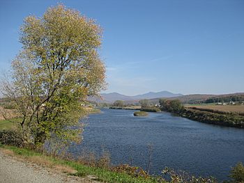
The Missisquoi River is a river that flows through two countries: the United States and Canada. It is about 80 miles (130 km) long. The river starts in northern Vermont and flows into southern Quebec. Finally, it empties into Missisquoi Bay, which is part of Lake Champlain.
This river helps drain water from the northern Green Mountains near the border between Canada and the US. It also drains parts of Quebec's Eastern Townships. The river has two main parts: the South Branch, which starts in Vermont, and the North Branch, which begins in Lake d'Argent in Eastman, Quebec. These two branches meet in Highwater, Quebec. After that, the river flows through Quebec for about 15 miles (24 km) before returning to Vermont near Richford. From there, it continues its journey to Missisquoi Bay in Lake Champlain.
Contents
What's in a Name?
The name "Missisquoi" has a cool history!
- According to the US Natural Resources Conservation Service, "Missisquoi" comes from an old Abenaki word, masipskoik. This means "where there is flint" or "where flint is found." Flint is a type of rock that was used to make tools. There was an Abenaki quarry (a place where rocks are dug up) for flint near Missisquoi Bay.
- The "Commission de toponymie du Québec" (Quebec's official place-name board) says that "Missisquoi" in Abenaki means "multitudes of water birds." This makes sense because many birds live near the river!
- Another old Abenaki name for the river was "Wazowategok," which means "to the river that turns around."
- The name "Rivière Missisquoi" officially became its name in Quebec on December 5, 1968.
The River's Journey
The Missisquoi River begins its journey in western Orleans County, Vermont, near Lowell. It starts at a height of about 247 metres (810 ft) (810 feet). This starting point is close to Route 58 and Belvidere Mountain.
From its source, the Missisquoi River flows for about 117.3 kilometres (72.9 mi) (73 miles). As it flows, it drops about 218 metres (715 ft) (715 feet) in height.
Upper Part in Vermont
In its upper section, the river flows mostly north. It passes through towns like Troy and North Troy. It also goes through Big Falls State Park and the village of Lowell. Along this part of its journey, it collects water from smaller streams like the East Branch Missisquoi River. A special area called the "Missisquoi & Trout Wild and Scenic River" also begins here. This natural park has many marshy areas along the river, stretching all the way to the Canada-US border.
Middle Part in Quebec
The river then crosses into Quebec. Here, it flows for about 24.1 kilometres (15.0 mi) (15 miles). It makes a big turn to collect water from the Mud stream. It also passes through the village of Highwater. Further along, it meets the Missisquoi River North and the Brock River. In this section, the river flows through Mansonville, Dunkin, and the small community of Glen Sutton in Sutton.
Lower Part in Vermont
After its journey through Quebec, the Missisquoi River re-enters Vermont. This lower section is about 58.5 kilometres (36.4 mi) (36 miles) long. It flows west through northern Franklin County. It passes by small towns like Richford, East Berkshire, Enosburg Falls, and Sheldon Springs.
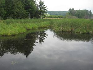
Near Interstate 89, the river turns north. It then flows through the Missisquoi National Wildlife Refuge for its last 5 miles (8.0 km) (3 miles). Finally, it enters the southern end of Missisquoi Bay. This bay is an arm of Lake Champlain that sits right on the border between Canada and Vermont. In its very last part, the river flows through a large marshy area in Swanton.
River Branches and Streams
Many smaller streams and branches flow into the Missisquoi River, adding to its water. These are called tributaries. Some of the named tributaries in Vermont include:
- Taft Brook in Westfield
- Beetle Brook in Troy
- Jay Brook in Jay
- Stanhope Brook in Richford
- The Trout River in Montgomery
- Tyler Branch in Enosburg
- Black Creek in Sheldon and Fairfield
- Hungerford Brook in Swanton and Highgate
A Look Back in Time
The Missisquoi River has been important for a long time.
- The Abenaki people, who are Native Americans, used the river as a pathway for their canoes. They traveled between Lake Champlain and the Saint-François River.
- Canoes could travel from Lake Champlain all the way to Mansonville, Quebec. There was a waterfall there, so people would carry their canoes (this is called a portage) for about 6 miles (9.7 km) (10 km) to Perkins Landing on Lake Memphremagog.
- Abenaki groups would gather at Eagle Point in Newport, Vermont, to catch and dry whitefish.
- After the American Revolution, people called Loyalists (who supported the British) moved to the Missisquoi Valley. They were some of the first settlers in this part of Quebec.
Protecting the River
In 2008, the US government started looking into protecting parts of the Missisquoi and Trout rivers. They wanted to see if these rivers could become "Wild and Scenic Rivers." This special title helps protect rivers from too much development and keeps them natural.
A group of local people and organizations studied the rivers. They wanted to see if the rivers met the special rules for this protection. They also looked at how it would help the ten towns along the rivers.
Good news! On December 19, 2014, about 46.1 miles (74.2 km) (74 km) of the Missisquoi River and the Trout River were officially added to the National Wild and Scenic River System. This means these parts of the rivers are now protected!
The Valley Bridge
There's a special bridge called the Valley Bridge that crosses the Missisquoi River. This bridge is unique because it sits right on the border between Canada and the United States!
- One end of the bridge is in Sutton, Quebec, near Glen Sutton.
- The other end is in Richford, Vermont, near East Richford.
- The bridge helps people who live in the area and vacationers travel between the two countries.
- It's a metal bridge with two main sections.
- A plaque on the bridge says it was built in 1929. The metal parts were made by Pittsburg Des Moines Steel Co., and the base was built by Cenedella & Compagny.
- This bridge is important for history! Since 1990, it has been listed in the National Register of Historic Places in the United States. It replaced an older bridge that was destroyed by a big flood in November 1927.
River Health
Scientists study the health of the Missisquoi River. In 2016, they found something interesting about the smallmouth bass fish in the river. About 60% of the male smallmouth bass had eggs. This is unusual for male fish. One possible reason for this could be pollution from farms, like a weedkiller called atrazine that washes into the river. Scientists continue to study this to understand how to keep the river healthy for all its creatures.
 | John T. Biggers |
 | Thomas Blackshear |
 | Mark Bradford |
 | Beverly Buchanan |


