Montgomery, Vermont facts for kids
Quick facts for kids
Montgomery, Vermont
|
|
|---|---|
 |
|
| Nickname(s):
"The Covered Bridge Town"
|
|

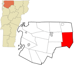
Location in Franklin County and the state of Vermont.
|
|
| Country | United States |
| State | Vermont |
| County | Franklin |
| Communities | Montgomery Montgomery Center Hectorville Hutchins West Hill |
| Area | |
| • Total | 56.7 sq mi (146.9 km2) |
| • Land | 56.6 sq mi (146.7 km2) |
| • Water | 0.08 sq mi (0.2 km2) |
| Elevation | 650 ft (198 m) |
| Population
(2020)
|
|
| • Total | 1,184 |
| • Density | 21/sq mi (8.1/km2) |
| Time zone | UTC-5 (Eastern (EST)) |
| • Summer (DST) | UTC-4 (EDT) |
| ZIP Codes | |
| Area code(s) | 802 |
| FIPS code | 50-45850 |
| GNIS feature ID | 1462151 |
Montgomery is a charming town located in Franklin County, Vermont, United States. It's often called "The Covered Bridge Town" because of its many beautiful historic bridges. In 2020, about 1,184 people lived here.
In 1963, a part of Avery's Gore, a piece of land in Franklin County, became part of Montgomery. Another section of Avery's Gore joined Belvidere in Lamoille County.
Contents
Exploring Montgomery's Geography
This town is located in the eastern part of Franklin County. It shares borders with Lamoille County to the south and Orleans County to the east.
Roads and Travel
Several important roads run through Montgomery. Vermont Route 118 goes northwest towards Berkshire and south towards Eden. Vermont Route 58 meets Route 118 at Montgomery Center. From there, it heads southwest over Hazens Notch to Lowell. Vermont Route 242 also ends at Montgomery Center, leading northeast over the Green Mountains to Jay.
Mountains and Rivers
The highest point in Montgomery is the summit of Big Jay. This mountain is a part of Jay Peak and stands at about 1,154 meters (3,786 feet) tall. Big Jay is found in the northeast corner of the town.
Montgomery covers a total area of about 146.9 square kilometers (56.7 square miles). Most of this area is land, with a small amount of water. The Trout River drains almost all of the town. This river flows northwest and is a branch of the Missisquoi River. A small part of the town in the southeast is drained by Calavale Brook, which flows into the Lamoille River. Both the Missisquoi and Lamoille rivers eventually flow into Lake Champlain.
Local Communities
Within the town of Montgomery, you'll find several smaller communities and places:
- Hectorville
- Hutchins
- Montgomery Center (with its own ZIP Code, 05471)
- Montgomery Village (with its own ZIP Code, 05470)
Hazen's Notch State Park
Hazen's Notch State Park is a natural area located on Vermont Route 58. This park is undeveloped, meaning it's kept mostly wild. It stretches across three towns, including Montgomery, and is found between Lowell to the east and Montgomery to the west.
A Look at Montgomery's History
The town of Montgomery received its official charter on March 15, 1780. This charter was granted by the Vermont General Assembly. The town was named to honor General Richard Montgomery (1738–1775), a brave hero of the Revolutionary War.
Preserving History
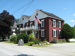
The Montgomery Historical Society was created in 1974. Its first goal was to buy and fix up the St. Bartholomew's Episcopal Church in Montgomery Village. This building is now known as Pratt Hall and serves as the home for the Montgomery Historical Society.
Historic Buildings and Bridges
Many buildings and bridges in Montgomery are so important that they are listed on the National Register of Historic Places. This means they are protected for their historical value. These include:
- Comstock Covered Bridge
- Fuller Covered Bridge
- Hectorville Covered Bridge (This bridge is currently taken apart and waiting to be restored)
- Hopkins Covered Bridge
- Hutchins Covered Bridge
- Longley Covered Bridge
- West Hill Covered Bridge
- Montgomery House (Montgomery, Vermont)
- St. Bartholomew's Episcopal Church (Now Pratt Hall)
- First Baptist Church (Now Kelton Hall, Montgomery Center for the Arts)
Health Studies
In 2008, the state informed residents of Montgomery and nearby towns about a health study. This study looked at health records from 1995 to 2006. It found that people living near a former asbestos mine had higher rates of a lung disease called asbestosis. Both state and federal governments are still studying this issue to understand it better.
Local Government and Representation
The town of Montgomery is part of the Essex-Orleans Senate district. This district also includes parts of Essex County, Orleans County, Franklin County, and Lamoille County. In 2021, the district was represented in the Vermont Senate by Russ Ingalls and Robert A. Starr.
Population Changes Over Time
| Historical population | |||
|---|---|---|---|
| Census | Pop. | %± | |
| 1800 | 41 | — | |
| 1810 | 237 | 478.0% | |
| 1820 | 293 | 23.6% | |
| 1830 | 460 | 57.0% | |
| 1840 | 548 | 19.1% | |
| 1850 | 1,001 | 82.7% | |
| 1860 | 1,262 | 26.1% | |
| 1870 | 1,423 | 12.8% | |
| 1880 | 1,642 | 15.4% | |
| 1890 | 1,734 | 5.6% | |
| 1900 | 1,876 | 8.2% | |
| 1910 | 1,721 | −8.3% | |
| 1920 | 1,658 | −3.7% | |
| 1930 | 1,386 | −16.4% | |
| 1940 | 1,208 | −12.8% | |
| 1950 | 1,091 | −9.7% | |
| 1960 | 876 | −19.7% | |
| 1970 | 651 | −25.7% | |
| 1980 | 681 | 4.6% | |
| 1990 | 823 | 20.9% | |
| 2000 | 992 | 20.5% | |
| 2010 | 1,201 | 21.1% | |
| 2020 | 1,184 | −1.4% | |
| U.S. Decennial Census | |||
The population of Montgomery has changed quite a bit since 1800. In 2000, there were 992 people living in the town. About 28.4% of households had children under 18. Most households (55.8%) were married couples living together.
The median age in Montgomery in 2000 was 42 years old. About 23.6% of the population was under 18.
Montgomery's Economy
Montgomery's economy relies a lot on tourism. This is because it is very close to Jay Peak Resort, a popular place for visitors. Farming and related businesses, known as Agribusiness, also play a big role in the town's economy.
Notable People from Montgomery
Many interesting people have connections to Montgomery:
- Dana Reed Bailey, a politician.
- Percival L. Shangraw, who served on the Vermont Supreme Court from 1958 to 1974. He was the Chief Justice from 1972 to 1974.
- Elle Purrier St. Pierre, an Olympian.
- Homer W. Wheeler, a U.S. Army officer and author.
See also
 In Spanish: Montgomery (Vermont) para niños
 | Jewel Prestage |
 | Ella Baker |
 | Fannie Lou Hamer |

