
Jay Peak (Vermont) facts for kids
Quick facts for kids Jay Peak |
|
|---|---|

Jay Peak in January, with an aerial tramway car visible to the right of the summit
|
|
| Highest point | |
| Elevation | 3,862 ft (1,177 m) |
| Prominence | 2,952 ft (900 m) |
| Listing | #8 New England Fifty Finest #81 New England 100 Highest |
| Geography | |
| Location | Orleans County, Vermont |
| Parent range | Green Mountains |
| Topo map | USGS Jay Peak |
| Climbing | |
| Easiest route | maintained hiking trail |
Jay Peak is a tall mountain in Vermont, USA. It's about 5 miles (8 km) south of the Canadian border. This mountain is the highest point in Orleans County. Much of Jay Peak is found within Jay State Forest.
The mountain gets its name from the nearby town of Jay. The town itself was named after John Jay. He was the very first Chief Justice of the United States. Jay Peak is part of the northern Green Mountains range. Nearby peaks include Big Jay to the southwest and North Jay Peak to the north. North Jay Peak is 3,438 feet (1,048 meters) tall.
Water Flow from Jay Peak
Jay Peak is part of a watershed. A watershed is an area of land where all the water drains into one main river or lake. Water from Jay Peak eventually flows into the Missisquoi River. This river then empties into Lake Champlain. From there, the water travels north into Canada's Richelieu River. Finally, it reaches the Saint Lawrence River and then the Gulf of Saint Lawrence.
The south side of the mountain sends its water into Jay Brook. This brook flows west into the Trout River. The Trout River then joins the Missisquoi River. Water from the northwest side of Jay Peak goes into Black Falls Brook. This brook also flows into the Trout River. The north and northeast parts of the mountain drain east into the Jay Branch of the Missisquoi River.
Hiking and Skiing at Jay Peak
Jay Peak is an important spot on the Long Trail. This famous hiking trail is 272 miles (438 km) long. It runs all the way through Vermont. Jay Peak is the northernmost major mountain that the Long Trail crosses.
The Jay Peak Resort is located on the northeast side of the mountain. This resort is a popular place for skiing and snowboarding. It offers many fun activities for visitors.
Mountain History
Jay Peak has some interesting history. On November 10, 1943, a training plane from the Royal Canadian Air Force crashed into the west side of the mountain. This happened during a heavy snowfall.
In the mid-1950s, two brothers named Ernest W. Gilpin and Wallace H. Gilpin worked hard to build a highway over Jay Peak. They were both state lawmakers and newspaper writers. Their goal was to connect the towns of Troy and Montgomery, Vermont. The Starr family from Troy generously gave land for the new road. This road is now known as Vermont Route 242.
The mountains across the highway to the south are named "Gilpin Mountain" in honor of the brothers. There is also a stone monument dedicated to them. It stands at the main entrance to the Jay Peak Resort.
Images for kids
-
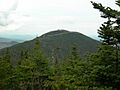
Jay Peak seen from Big Jay

