
Belvidere, Vermont facts for kids
Quick facts for kids
Belvidere, Vermont
|
|
|---|---|

|
|

Belvidere, Vermont
|
|

Belvidere, Vermont
Location in the United States
|
|
| Country | United States |
| State | Vermont |
| County | Lamoille |
| Communities | Belvidere Center Belvidere Corners Belvidere Junction |
| Area | |
| • Total | 32.14 sq mi (83.24 km2) |
| • Land | 32.09 sq mi (83.10 km2) |
| • Water | 0.05 sq mi (0.13 km2) |
| Elevation | 1,053 ft (321 m) |
| Population
(2020)
|
|
| • Total | 358 |
| • Density | 11/sq mi (4.3/km2) |
| Time zone | UTC-5 (Eastern (EST)) |
| • Summer (DST) | UTC-4 (EDT) |
| ZIP code |
05442
|
| Area code(s) | 802 |
| FIPS code | 50-04375 |
| GNIS feature ID | 1462038 |
Belvidere is a small town in Lamoille County, Vermont, in the United States. In 2020, about 358 people lived there.
Belvidere is made up of a few smaller areas. These include Belvidere Center, Belvidere Corners, and Belvidere Junction. In 1963, a part of Averys Gore became part of Belvidere. Another part of Averys Gore joined the town of Montgomery.
Contents
Where is Belvidere?
Belvidere is the northernmost town in Lamoille County. It shares a border with Franklin County to the north. The town covers about 83.2 square kilometers (32.1 square miles). Most of this area is land, with only a small amount of water.
Rivers and Roads
The North Branch of the Lamoille River flows through the middle of Belvidere. Most of the town's homes and buildings are located in this river valley.
Vermont Route 109 is a main road that follows the valley. It connects to Vermont Route 118 at Belvidere Corners. Route 109 goes southwest to Jeffersonville. Route 118 goes north to Montgomery and southeast to Eden.
Who Lives in Belvidere?
The number of people living in Belvidere has changed over the years. Here is a look at the population from 1810 to 2020:
| Historical population | |||
|---|---|---|---|
| Census | Pop. | %± | |
| 1810 | 217 | — | |
| 1820 | 198 | −8.8% | |
| 1830 | 185 | −6.6% | |
| 1840 | 207 | 11.9% | |
| 1850 | 256 | 23.7% | |
| 1860 | 366 | 43.0% | |
| 1870 | 369 | 0.8% | |
| 1880 | 400 | 8.4% | |
| 1890 | 571 | 42.8% | |
| 1900 | 428 | −25.0% | |
| 1910 | 429 | 0.2% | |
| 1920 | 363 | −15.4% | |
| 1930 | 258 | −28.9% | |
| 1940 | 220 | −14.7% | |
| 1950 | 207 | −5.9% | |
| 1960 | 155 | −25.1% | |
| 1970 | 189 | 21.9% | |
| 1980 | 218 | 15.3% | |
| 1990 | 228 | 4.6% | |
| 2000 | 294 | 28.9% | |
| 2010 | 348 | 18.4% | |
| 2020 | 358 | 2.9% | |
| U.S. Decennial Census | |||
Population Details from 2000
In the year 2000, Belvidere had 294 residents. There were 114 households, which are groups of people living together. Most of the people were White. A very small number were from two or more races or were of Hispanic or Latino background.
Many households had children under 18 living with them. More than half of the households were married couples. The average household had about 2.58 people.
The population included people of all ages. About 28% were under 18 years old. The median age was 35 years. This means half the people were younger than 35 and half were older.
The average income for a household in 2000 was about $44,583 per year. For families, it was about $50,500. A small percentage of families and individuals lived below the poverty line.
Famous People from Belvidere
- Berthold C. Coburn was a notable person from Belvidere. He was a member of the Vermont House of Representatives. He also ran for governor in 1946.
Images for kids
-
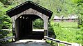
The Morgan Covered Bridge in Belvidere.
-
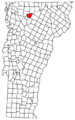
A map showing Belvidere, Vermont.
See also
 In Spanish: Belvidere (Vermont) para niños
