Missisquoi River North facts for kids
Quick facts for kids Missisquoi River North |
|
|---|---|

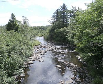
Missisquoi River North downstream from East River Road near Bolton.
|
|
| Country | Canada |
| Province | Quebec |
| Region | Estrie |
| Regional County Municipality | Memphrémagog Regional County Municipality |
| Municipality | Eastman, Stukely-Sud, Saint-Étienne-de-Bolton, Bolton-Est, Mansonville and Potton |
| Physical characteristics | |
| Main source | Lac d'Argent Eastman 249 m (817 ft) 45°18′37″N 72°18′51″E / 45.31028°N 72.31416°E |
| River mouth | Missisquoi River Potton 153 m (502 ft) 45°01′36″N 72°25′48″E / 45.02666°N 72.43°E |
| Basin features | |
| Progression | Missisquoi River, Lake Champlain, Richelieu River, Saint Lawrence River |
| Tributaries |
|
The Missisquoi North River is a river in Quebec, Canada. It is a branch, or "tributary," of the larger Missisquoi River. This river flows through several towns in the Estrie region, including Eastman, Stukely-Sud, Saint-Étienne-de-Bolton, Bolton-Est, Mansonville, and Potton.
River's Journey
The Missisquoi North River starts its journey west of Lake Stukely. It begins with two small streams that flow into Parker Lake. From there, the water travels a short distance to Lac d'Argent.
From Lakes to Streams
The river flows through Lac d'Argent, which is about 1.7 kilometres (1.1 mi) long. After leaving this lake, the Missisquoi North River continues south for about 7.1 kilometres (4.4 mi). It then reaches Trousers Lake, crossing it towards the southwest. Trousers Lake also gets water from "Long Pond Lake."
Downstream Flow
After Trousers Lake, the river flows for about 40.9 kilometres (25.4 mi). Along the way, it collects water from other smaller streams. It passes by Étang Grass and the Petite rivière Missisquoi Nord. The river also flows under the Nicolas-Austin road bridge in Bolton-Est.
Further downstream, it meets Ives stream and the outlet from Johnson Pond. The river then winds its way south for many kilometers, passing through areas like Mansonville.
Where it Ends
Finally, the Missisquoi North River flows into the main Missisquoi River. This happens in the town of Potton, near a small place called Highwater.
What's in a Name?
The name "Missisquoi" comes from the Abenaki language. It means "multitudes of water birds." This name makes a lot of sense for a river that likely had many birds living near it!
The official name "Rivière Missisquoi Nord" was recognized on December 5, 1968, by the Commission de toponymie du Québec.
 | Roy Wilkins |
 | John Lewis |
 | Linda Carol Brown |

