
Saint-François River facts for kids
Quick facts for kids Saint-François River |
|
|---|---|

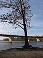
A tree on the banks of the
Saint-François River in Drummondville |
|

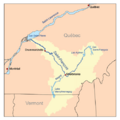
Map of the Saint-François River watershed
|
|
| Native name | Rivière Saint-François |
| Country | Canada |
| Province | Quebec |
| Region | Estrie, Chaudière-Appalaches, Centre-du-Québec |
| Cities | Sherbrooke, Drummondville |
| Physical characteristics | |
| Main source | Lac Saint-François Lambton, Estrie, Quebec, Canada 289 m (948 ft) 45°53′55″N 71°09′28″W / 45.89861°N 71.15778°W |
| River mouth | Pierreville, Centre-du-Québec, Quebec, Canada 46°07′09″N 72°55′28″W / 46.11917°N 72.92444°W |
| Length | 218 km (135 mi) |
| Discharge (location 2) |
|
| Basin features | |
| Basin size | 10,230 km2 (3,950 sq mi) |
| Tributaries |
|
The Saint-François River is a river in Quebec, Canada. It flows into the Saint Lawrence River. This river is about 218 km (135 mi) long.
It starts at Lake Saint-François in the Chaudière-Appalaches region, southeast of Thetford Mines. The river flows southwest towards Sherbrooke. Then, it turns northwest towards Drummondville. Finally, it empties into the Saint Lawrence River near Pierreville.
Contents
What's in a Name?
The Saint-François River got its name from early explorers. Jesuits, who were Christian missionaries, explored this area when it was under French rule. They named the river after Saint Francis Xavier (1506–1552). Another person named François de Lauzon also contributed to the name.
Where Does the River Flow?
The Saint-François River has an interesting path. It starts in the northeast and flows southwest for a while. Then, about halfway, it changes direction. It turns and flows from the southeast to the northwest.
The river begins at Lake Saint-François. From there, it heads southwest towards the city of Sherbrooke. On its journey, it passes through other lakes like Lake Aylmer and Lake Louise. It also flows through many towns and villages.

When the river reaches Sherbrooke, it gets more water from the Massawippi River and the Magog River. After Sherbrooke, it continues its journey northwest. It flows through towns such as Windsor, Richmond, and Drummondville. The river then finishes its long journey by flowing into Lake Saint-Pierre, which is part of the Saint Lawrence River.
A Look Back in Time

The Saint-François River has been important for a very long time. Native American groups, especially the Abenakis, traveled along this river. The Odanak Indian Reservation, which is still home to about 400 people today, has been here since 1670.
A fort called Fort Crevier was built by the river in 1687. There was also a temporary mission for the Abenaki people near the river. When the Abenaki mission moved to Odanak, the village took the name "Saint-François." Odanak is located right on the banks of the Saint-François River, not far from Lake Saint-Pierre.
In the early 1800s, land was set aside for Native American refugees near the river. This included a large area of about 32.4 kilometres (20.13 mi) in 1805 near the village of L'Avenir. More land was granted in 1853 by Petit Lac Saint-François.

Images for kids
-
A tree on the banks of the Saint-François River in Drummondville
-
Map of the Saint-François River watershed
-

Rivière Saint-François at Dudswell, QC
-
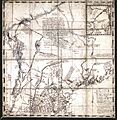
Map 1756 Blanchard & Langdon 1m
-
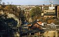
The Saint-François river at Sherbrooke in the 1950s
Related Places and Rivers
- Grand lac Saint François
- Lake Saint-François
- Lake Aylmer
- Lake Louise (Quebec)
- Lake Saint-Pierre
- List of rivers of Quebec
